Take a hike on the quiet, east side of Mount Mitchell State Park by following the Buncombe Horse Range Trail to Fork Ridge and Maple Camp Bald, two summits with wonderful views. Although this hike begins amidst the crowds at the Mt. Mitchell summit parking, you’ll soon leave them behind as you descend through thick southern Appalachian spruce-fir forest on the Mt. Mitchell Trail. You’ll leave the state park boundary and follow the Buncombe Horse Range Trail north in Pisgah National Forest, skirting the eastern slopes of the Black Mountains. This lonely trail leads to a bald on Fork Ridge, and eventually Maple Camp Bald. Both landmarks boast excellent campsites and even better views of the South Toe River Valley and central Black Mountains. From there you follow the seldom-used Big Tom Gap Trail to the crest and the Deep Gap Trail south across Big Tom and Mt. Craig. Until you reach Mt. Craig, you’ll be perplexed by the hours you’ve spent in complete isolation while hundreds of people filter through the summit parking. After more outstanding views from Big Tom and Mt. Craig, the loop finishes at Mt. Mitchell, the tallest peak in the East. This relatively short full-day trip is jam-packed with more views and variance than almost any hike in the region.
Seasonal Access – The Blue Ridge Parkway and Mount Mitchell State Park are normally closed all winter. From late November to early March you will likely not be able to drive in this area. You can create a nice weekend backpacking trip by taking the Mt. Mitchell Trail and camp at Commissary Hill or Maple Camp Bald.
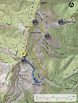
- Mile 0.0 – Beginning at the parking lot for the summit of Mt. Mitchell, take the Balsam Nature Trail (white triangle blaze) southeast from the lower end of the road. You can also use the Mt. Mitchell Trail which is located closer to the summit. Both trails converge in 0.4-mi from the parking lot.
- Mile 0.4 – The Balsam Nature Trail meets the Mt. Mitchell Trail [190] (blue diamond blaze) and Mountains-to-Sea Trail [440] (white blaze) at a T-junction. Turn left continuing downhill through thick southern Appalachian spruce-fir forest.
- Mile 1.6 – Mt. Mitchell Trail and MST meets the Buncombe Horse Range Trail [191] (white blaze) at Commissary Hill. There are excellent campsites to the right. Turn left following all three trails north.
- Mile 1.7 – Turn left on the Buncombe Horse Range Trail [191] (white blaze) at a Y-junction. The Mt. Mitchell Trail and MST turn right. The Buncombe Horse Range Trail for the next 1.8 miles is mostly flat as it follows the eastern slope of the Black Mountains.
- Mile 3.5 – The Buncombe Horse Range Trail makes a big left turn beside the bald on Fork Ridge. From this sparse field you have open views of the South Toe River Valley to the east, Mt. Mitchell and Mt. Craig directly overhead, and Balsam Cone and Maple Camp Bald to the north. With a keen eye, and the help of a camera zoom, you should be able to spot the observation tower on Mt. Mitchell.
- Mile 4.1 – Y-junction with the Big Tom Gap Trail [191A] (blue blaze) on the left. Continue straight on the Buncombe Horse Range Trail crossing Thee Creek. This section is rarely used so the trail may be heavily overgrown.
- Mile 4.7 – Reach Maple Camp Bald, a 5,613-foot grassy pinnacle on the eastern side of the Black Mountains. This bald is an excellent campsite with expansive views from east to west. To the east and south lies the South Toe River Valley and the Blue Ridge Escarpment. Mt. Mitchell rises to the southwest directly above Fork Ridge. Big Tom and Mt. Craig are to the right closer to your position. Due west the large U is Big Tom Gap hundreds of feet below Big Tom and Balsam Cone.
- Mile 5.4 – Turn right on the Big Tom Gap Trail [191A] (blue blaze) which climbs steeply to Big Tom Gap.
- Mile 5.9 – The Big Tom Gap Trail ends at Big Tom Gap. Turn left on the Black Mountain Crest Trail [179] (yellow blaze) and Deep Gap Trail (orange triangle blaze). On your climb up you’ll encounter two sections of exposed rock with ropes for assistance.
- Mile 6.2 – Pass by a cliff overlook on the right side of the trail with open views west and north of the Black Mountains. Balsam Cone and Cattail Peak are the largest mountains in view.
- Mile 6.4 – Reach the summit of Big Tom (6,581 feet). The summit is surrounded by a “ghost forest” of conifers suffering from acid rain and the woolly adelgid blight.
- Mile 6.6 – The trail crosses the rocky, exposed summit of Mount Craig (6,647 feet). Please stay between the log guides, the cliffs are home to very rare flora and are easily damaged. You will still have excellent views from south to north of the Black Mountains and Great Craggy Mountains. On clear days you should be able to see the Great Balsam, Plott Balsam, Great Smoky, Newfound, and Bald Mountains from the summit. Immediately west the notable two peaks are Blackstock Knob and Big Butt. As you walk south you will have an open view of Mt. Mitchell.
- Mile 7.5 – The Deep Gap Trail and Black Mountain Crest Trail end at the Mt. Mitchell parking lot. Head towards the museum and gift shop to pick up the paved walkway to the summit.
- Mile 7.7 – Reach the summit of Mount Mitchell, the highest mountain in the East at 6,684 feet. From the summit you have phenomenal 360° views of the region. Due south Mt. Gibbes and Clingmans Peak rise above Stepps Gap. Pinnacle and Blackstock Knob are the notable peaks on either side of Clingmans Peak. Big Butt is the last big peak of the western Blacks before the ridge descends to Cane River Gap. You will have better views north and east from the path below the summit. The peaks of Linville Gorge, Grandfather Mountain, and the Roan Highlands are located to the northeast. Mt. Craig and Balsam Cone are the dominant peaks immediately north.
- Mile 8.0 – Hike ends at the Mt. Mitchell parking lot.