Loading...

🔥 End of Summer sale! 50% off on Supporter Accounts — now through September 1st. Learn More.

Manassas National Battlefield Groveton

Directions
Map
Pictures
Send to App
Distance:
5.7 Miles / 9.2 km
Type:
Loop
Difficulty:
Easy
Time to Hike:
2 hours, ~51 minutes
Features:
Surface Type:
Dirt
Town:
Manassas, Virginia
Directions:
38.812551, -77.521505
Added:
April 03, 2025
Updated:
April 06, 2025
Guide by:
Copy Trail Link Hiking this trail? Send a friend or family member a link to this trail guide for your own safety. Hike at your own risk (disclaimer)
Loading...
Loading...
124'

Total Change
343'

Ascent
343'

Descent

Download the Trail Route for Offline Use

Supporters get exclusive access to download trail routes to the MyHikes app for offline use. Stay prepared on your adventure, even without an internet connection! Become a Supporter today to unlock this feature and hike with confidence.

Send to App

Manassas National Battlefield Groveton

The second of two great hikes in the Manassas Battlefield Park the Second Manassas Trail (6.2 miles) is slightly longer than the First Manassas Trail (5.3 miles). This loop passes several historic landmarks including the Groveton Confederate Cemetery and the battles at Deep Cut.

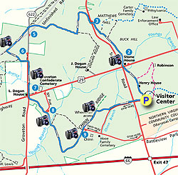
From the back of the visitors center walk past the Henry House downhill to the intersection of Lee Hwy and Sudley Road where the Stone House stands. Remember that there are many trails within the park, just follow the Second Manassas Trail signs that are marked by blue circles on brown thin posts.

After crossing Lee Hwy and passing the Stone House climb over the first rise and continue through two fields to the top of Mathews Hill and line of Canons. Continue straight downhill towards the parking area for Mathews Hill. At the parking area cross Sudley Road turning right and continue following the trail as it follows the boundary of the field back to the left.

At the the junction of the Dogan Ridge Trail turn right towards the Unfinished Railroad as the trail follows the border of another field then veering left, than right before emerging at the Unfinished Railroad parking area and RT622. Cross RT622 where the trail continues on the caddy corner of the intersection and arriving at the intersection of the Deep Cut Loop Trail in another 0.2 miles. Continue straight shortly crossing two wooded footbridges and stairs then arriving in 0.1 miles at the Second Bull Run Monument constructed by Union solider's at the end of the Civil War. The First Bull Run Monument is located behind the Henry House and visitors center.

Turn left downhill at the monument passing through the deep cut battlefield area where the trail turns right, then back to the left and climbing to meet RT622. After crossing RT622 follow the trail to the right for 0.3 miles crossing Dogan Creek, then climbing a small rise and arriving at the intersection of Rt622 and Lee Hwy. At the intersection there is a side trail on the left to the Groveton Confederate Cemetery. The L. Dogan House on the right is one of only three remaining Civil War era houses in the park.

Cross Lee Hwy and enter the field on the left climbing a small rise. The trail now descends to the right before entering the woods. In 0.1 miles emerge at a parking area and monuments erected by the State Of New York. The trail descends on the right and arrives at a wooden bridge and Youngs Branch Creek in 0.2 miles. Cross the footbridge, then turn right at the junction. Climb for another 0.5 miles before turning to the left at the crest. In 0.1 miles enter a wooded area then emerge onto Chinn Ridge and open fields. Follow Chinn Ridge past the parking area where you climb over a low picket fence. The trail is now paved as it follows the ridge before turning right at the Webster Memorial Monument in 0.3 miles.

Descend past the Webster monument through the field then turn left onto the paved park road. Follow the road for 0.3 miles where it crosses Sudley Road and entrance to the visitors center.

Explore 27 trails near Manassas, VA
  1. Parking

    38.812551, -77.521505
  2. Main Trailhead

    38.812551, -77.521505
No community routes found. To add your own hike as a Community Route for this Trail guide, leave a Trip Report with an attached GPX file.

Hazards

Ticks - Lyme Disease More Info (CDC)

Seasons

All

Photo Albums

+ Add Photo Album

Upload your photos from the trail to help others know what to expect.

Trip Reports (Reviews)

Rated 3.36 out of 5 based on 14 ratings.
By: aldikuma
5.7 miles / 9.2 km
November 11, 2017
Chilly day for a hike, but this was a good, easy length. If you love history and long walks, do this hike. The trails are well marked and the description below is excellent. Be sure to stop at all the markers to take in what happened here over 156 years ago, and perhaps have a moment of silence for the lives lost. The only thing I will note are the road crossings - there are no crosswalks so use caution, especially crossing Lee Hwy, and again at Sudley Rd to the Visitors Center at the end. Also, it is free to enter and park.
Legacy Review
By: Jeff P
5.7 miles / 9.2 km
January 29, 2017
A great trail. I took my dog and she had no issues. Not as crowded as 1st Manassas Battlefield. If you are a Civil War history buff, you will enjoy this trail (as well as 1st Manassas Trail). It is at least 6.2 miles in length. The trail is well marked except for a few spots. Good variety of meadows and woodland. Amazing that it is so close to town but does not feel that way during the hike.
Legacy Review
By: Steve
5.7 miles / 9.2 km
May 27, 2016
Had a fine hike on an interesting trail with several informative historical markers. The printable map for this hike has other historical information on several points along the way. Trail in good condition, just one longer muddy patch and several shorter ones of no significance. The trail churned up in parts from horses. Quite a bit of the trail is in the open so sun protection is important. Unlike a previous review, no ticks, few bugs of any kind. Movie on the hour at the visitor's center. As I write this the description says there's a $3 fee per person but according to staff this is no longer the case -- it is now a fee-exempt site. (An outlying trail sign still confusingly says to pay the fee.) Was glad to have the GPS to keep me on track.
Legacy Review

Weather Forecast

In Manassas, VA

Explore Hiking Trails

You May Also Like

New York's Best Waterfalls - Whether you're planning a day hike, roadside stop, or a leisurely short walk, this guide provides hikers, travelers, and locals alike with 63 different locations to over 100 scenic waterfalls to help plan your next adventure!
Explore

New York's Best Waterfalls

Whether you're planning a day hike, roadside stop, or a leisurely short walk, this guide provides hikers, travelers, and locals alike with 63 different locations to over 100 scenic waterfalls to help plan your next adventure!

Read
25 Best Day Hikes in North Carolina - Discover the top 25 best day hikes in North Carolina, from breathtaking waterfalls to mountain peaks. Explore hidden gems, scenic views, and trails suitable for all skill levels, perfect for your next outdoor adventure.
Explore

25 Best Day Hikes in North Carolina

Discover the top 25 best day hikes in North Carolina, from breathtaking waterfalls to mountain peaks. Explore hidden gems, scenic views, and trails suitable for all skill levels, perfect for your next outdoor adventure.

Read

Before you boogie...

Find our trail guides useful? Consider becoming a Supporter to unlock perks!

MyHikes is an indie platform that makes exploring public trails easier for everyone. The platform has no investors, no ads, and is owned and operated by one person, Dave Miller. Dave has personally mapped and written over 1,800 trail guides on MyHikes for the public to explore. MyHikes has helped millions outdoor enthusiasts plan their next adventure.

But it takes a lot of time 🕦, money 💰, work, and espresso shots ☕ to run MyHikes, including hiking , mapping , writing , and publishing new trails with high-quality (accurate) information... along with software engineering (coding) the platform like building new features, website and mobile app development (iOS and Android), site maintainance . and much much more.

Supporters unlock website and mobile app perks with an annual one-time payment of $25 (you renew) 😎👍. Or you can simply make a Donation of your choice. Otherwise, you can support us by telling your friends about MyHikes - both quick and free 🎉

Admin user profile picture

Dave Miller
MyHikes Founder