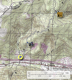
The Appalachian Trail moves north out of the SNP and passes under I66
at Manassas Gap. This is a moderate to easy 5 mile hike that ventures
into the G. Richard Thompson Wildlife Management Area before turning
around at the Manassas Gap Shelter. With a steady climb at the beginning of the hike you still get a decent workout with over 1,000ft of vertical gain. Also pass Barringer Point lookout with wooden bench that makes for a nice break along the hike.
- Mile 0.0 – From the parking area on VA725 head north on the white blazed Appalachian Trail (AT) and immediately cross a wooden footbridge over the only stream on the hike. The AT climbs over the first rise making a couple of switchbacks, then descends and crosses a small stream before climbing the steepest section of the hike. Make several more switchbacks and level off at the intersection of the overlook trail.
- Mile 0.7 - Turn right on the blue blazed overlook trail for 120 feet to Barringer Point and view towards Hardscrabble Mountain. Return to the AT and continue north. The AT will shortly start climbing the ridge again and pass 2 sections of rock wall used by farmers to contain livestock. Continue along the AT and arrive at yellow markings on trees either side of the trail.
- Mile 1.8 - The yellow markings designate the G. Richard Thompson Wildlife Management Area boundary. Continue along the AT for another 0.6 miles to the intersection of the Ted Lake Trail.
- Mile 2.4 - Turn right staying on the white blazed AT, then shorty turn right again at the sign for Manassas Gap Shelter. Follow the side trail to the shelter.
- Mile 2.5 - At the shelter there is a trail on the right leading to a spring. Turn around and retrace your route back to the parking area on VA725.
- Mile 4.8 - Arrive back at the AT parking area on VA725.