Loading...

Lost Lake Butte Trail

Directions
Map
Pictures
Send to App
Distance:
3.3 Miles / 5.3 km
Type:
Out-and-Back
Difficulty:
Moderate
Time to Hike:
1 hour, ~39 minutes
Features:
Surface Type:
Dirt
Park:
Mount Hood National Forest
Town:
Lost Lake Resort, Oregon
Directions:
45.49632, -121.814221
Added:
July 09, 2025
Updated:
July 10, 2025
Copy Trail Link Hiking this trail? Send a friend or family member a link to this trail guide for your own safety. Hike at your own risk (disclaimer)
Loading...
Loading...
1,154'

Total Change
1,116'

Ascent
1,107'

Descent

Download the Trail Route for Offline Use

Supporters get exclusive access to download trail routes to the MyHikes app for offline use. Stay prepared on your adventure, even without an internet connection! Become a Supporter today to unlock this feature and hike with confidence.

Send to App

Lost Lake Butte Trail

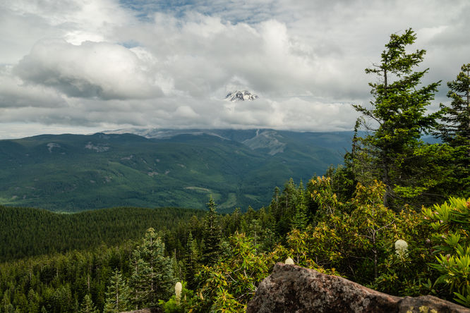
This is a great family friendly hike that starts from Lost Lake Campground and Resort, and ascends up an ancient shield volcano. At the top, views extend to the east and north, with Mount Hood as the prominent landscape feature in view. The top is the site of an old fire lookout building, but only the foundations remain. The summit has ample space to sit and enjoy the views from atop large rocks and boulders. 

You can start the hike from the campground, from the day use area, or from the Old Skyline Trailhead just before the campground entrance if you want to avoid the Lost Lake Resort day use fee. This GPS track shows the hike beginning from Loop C of the campground. The trail never feels too steep as it ascends up the peak, is well graded and includes a few switchbacks. Most of the trail is quite wide, sometimes gets rocky and rooty but otherwise very well marked and good tread. It is a good family friendly hike, although its moderate hike difficulty, as well as the steep cliffs on the east side of the summit is something to keep in mind. Although the summit area is quite wide and easy to avoid getting too close to the edge if you have younger kids along. If you time this hike in June, you will also be able to enjoy the beautiful pink Pacific Rhododendrons in bloom along the trail. There's also a few beargrass that may be in bloom in late June as well while the rhododendrons are in bloom, as it was for us.

Other Nearby Hikes

If you're camping or planning to explore the area further, consider hiking the Lost Lake Loop which provides scenic views of Lost Lake and its surrounding mountains.
Explore 20 trails near Lost Lake Resort, OR
  1. Parking

    45.49632, -121.814221
  2. Main Trailhead

    45.49632, -121.814221
  3. View of Mt Hood from the top of Lost Lake Butte

    45.495554, -121.795882
    View of Mt Hood from the top of Lost Lake Butte
No community routes found. To add your own hike as a Community Route for this Trail guide, leave a Trip Report with an attached GPX file.

Seasons

Summer, Fall

Weather Forecast

In Lost Lake Resort, OR

Explore Hiking Trails

You May Also Like

Colorado's Million Dollar Highway - Plan a day's drive adventure along the iconic Million Dollar Highway in Colorado. Explore the best short trails, roadside stops, waterfalls, vistas, ghost towns, and hot springs within a ~6 hour road trip.
Explore

Colorado's Million Dollar Highway

Plan a day's drive adventure along the iconic Million Dollar Highway in Colorado. Explore the best short trails, roadside stops, waterfalls, vistas, ghost towns, and hot springs within a ~6 hour road trip.

Read
Glacier's Going-to-the-Sun Road - Discover the breathtaking beauty of Glacier National Park along the iconic Going-to-the-Sun Road. From stunning roadside stops to picturesque waterfalls and vistas, this engineering marvel offers endless opportunities for exploration.
Explore

Glacier's Going-to-the-Sun Road

Discover the breathtaking beauty of Glacier National Park along the iconic Going-to-the-Sun Road. From stunning roadside stops to picturesque waterfalls and vistas, this engineering marvel offers endless opportunities for exploration.

Read
New York's Best Waterfalls - Whether you're planning a day hike, roadside stop, or a leisurely short walk, this guide provides hikers, travelers, and locals alike with 63 different locations to over 100 scenic waterfalls to help plan your next adventure!
Explore

New York's Best Waterfalls

Whether you're planning a day hike, roadside stop, or a leisurely short walk, this guide provides hikers, travelers, and locals alike with 63 different locations to over 100 scenic waterfalls to help plan your next adventure!

Read

Before you boogie...

Find our trail guides useful? Consider becoming a Supporter to unlock perks!

MyHikes is an indie platform that makes exploring public trails easier for everyone. The platform has no investors, no ads, and is owned and operated by one person, Dave Miller. Dave has personally mapped and written over 1,800 trail guides on MyHikes for the public to explore. MyHikes has helped millions outdoor enthusiasts plan their next adventure.

But it takes a lot of time ๐Ÿ•ฆ, money ๐Ÿ’ฐ, work, and espresso shots โ˜• to run MyHikes, including hiking , mapping , writing , and publishing new trails with high-quality (accurate) information... along with software engineering (coding) the platform like building new features, website and mobile app development (iOS and Android), site maintainance . and much much more.

Supporters unlock website and mobile app perks with an annual one-time payment of $25 (you renew) ๐Ÿ˜Ž๐Ÿ‘. Or you can simply make a Donation of your choice. Otherwise, you can support us by telling your friends about MyHikes - both quick and free ๐ŸŽ‰

Admin user profile picture

Dave Miller
MyHikes Founder