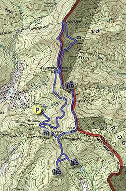
This hike explores the outstanding rocky summits on the eastern Swannanoa Rim around the border of the Montreat and Ridgecrest Conference Centers. Montreat is a small community in the Swannanoa Valley that features a private college, conference center, and 40+ miles of trails in 2,500+ acres of dedicated wilderness. The Ridgecrest Conference Center has 1,300 acres between Montreat and I-40 with many trails to explore.
This hike begins with the Lookout Trail, the most popular short hike in Montreat for a good reason. The hike is only 1.4 miles round-trip and the views from Lookout Rock are outstanding. While most hikers turn around here, you can continue straight towards Ridgecrest to visit two rocky knobs with big views. You’ll then follow the East Ridge Trail along the eastern Swannanoa Rim before returning to the parking lot. For the distance and difficulty, the views on this hike cannot be beat in this region of North Carolina.
When you enter Montreat stop by the Montreat Store on the 2nd floor of the Moore Center Building. This is at the intersection of Lookout Road and Assembly Drive beside Lake Susan. They have a free paper map and you can also purchase a color topographic map for $8.99.
- Mile 0.0 – Follow the Lookout Trail (yellow blaze) on the left side of the upper parking lot. This is one of the most popular trails in Montreat and as a result is easy-to-follow and in good condition.
- Mile 0.4 – Cross intersection with the Old Trestle Road (white blaze). After this intersection you’ll begin climbing steeply over exposed rock.
- Mile 0.65 – The Lookout Trail ends at the top of Lookout Rock (3,621 feet). From this massive cluster of outcroppings below the summit of Lookout Mountain you have outstanding 270° views. The Swannanoa Valley lies to the west with the distant Great Balsam Mountains on the horizon. The Swannanoa Mountains to the southwest rise abruptly from the valley. Montreat lies far below to the northwest with the Great Craggy Mountains rising above. The row of peaks known as the Seven Sisters run northeast from Montreat along the Middle Mountain massif towards Graybeard Mountain. Although Graybeard Mountain appears as the tallest peak due north, Pinnacle, the conical peak on the right is nearly 500 feet taller. Continue south beginning the East Ridge Trail (gray blaze).
- Mile 0.9 – Reach the top of Lookout Mountain (3,760 feet). At the Y-junction turn right on the Hickory Ridge Trail (blue blaze).
- Mile 1.05 – The Hickory Ridge Trail ends at a Y-junction with the Old Mitchell Toll Road (no blaze). Turn right on the Old Mitchell Toll Road heading south.
- Mile 1.15 – At a T-junction turn left on the Rattlesnake Trail entering the Ridgecrest Conference Center property.
- Mile 1.2 – At a T-junction turn left on the Copperhead Trail.
- Mile 1.3 – T-junction with the Copperhead Trail turning right and the Copperhead Summit Trail on the left. Turn left on the summit trail.
- Mile 1.35 – Reach the summit of Copperhead Mountain (3,520+ feet). From this fire-scarred knob you have excellent views south and east. The Hickory Nut Mountains rise due south over the trees. The most striking view is southeast of I-40 winding through Swannanoa Gap. Kitsuma Peak rises directly above the interstate highway. Further east the mountains drop sharply into the Catawba River Valley, with the distant South Mountains on the horizon. You can also spot Chestnutwood Mountain, Mackey Mountain and Narrows Knob above the eastern ridgelines.
- Mile 1.45 – Turn left on the Copperhead Trail heading west.
- Mile 1.55 – Copperhead Trail ends at a Y-junction with the Rattlesnake Trail. A left would take you to the Ridgecrest Conference Center. Continue straight.
- Mile 1.6 – Turn left on the Rattlesnake Summit Trail at a T-junction.
- Mile 1.7 – Trail ends at Rattlesnake Mountain (3,540+ feet). This spectacular rocky summit feels similar to Lookout Rock because of its panoramic views west and north, with the added bonus of southeast views above the trees of Swannanoa Gap. The view of Montreat is obscured by Lookout Mountain to the north, but you still have excellent views of the Great Craggy Mountains and Seven Sisters. The Swannanoa Valley lies to the west. Return to the trail heading north.
- Mile 1.8 – At the T-junction with the Rattlesnake Trail continue straight.
- Mile 2.0 – Continue north on the Old Mitchell Toll Road crossing back into the Montreat Conference Center property.
- Mile 2.1 – Turn left on the Hickory Ridge Trail.
- Mile 2.2 – Once atop Lookout Mountain turn right on the East Ridge Trail (gray blaze). (You can go straight to return to the parking lot for a 3.1-mile hike.)
- Mile 2.55 – Cross the top of Boggs Bunion (3,887 feet).
- Mile 2.7 – Y-junction with a side trail on the right to Buck Flats and the Old Mitchell Toll Road, veer left.
- Mile 3.0 – The East Ridge Trail flattens out through the long, wide Buck Gap (3,627 feet). You’ll veer right at a Y-junction with the Buck Gap Trail (blue blaze) on the left. Then in ~100 feet veer left at a Y-junction with a right spur to the Old Mitchell Toll Road. At a third Y-junction veer right on the East Ridge Trail, an unmarked trail turns left connecting to the Buck Gap Trail.
- Mile 3.2 – Just below the summit of Brushy Mountain is an open view east and north. Heartbreak Ridge and Snooks Nose are the two ridgelines below in succession. Beyond those ridgelines the prominent peaks are Narrows Knob and Mackey Mountain. To the left are the distant Hawksbill Mountain and Table Rock Mountain of Linville Gorge. You might be able to pick out the fire tower on Green Knob above the Blue Ridge Parkway to the northeast. To the north Clingmans Peak is the blackish mountain with communications towers between Graybeard Mountain (left) and Pinnacle (right).
- Mile 3.3 – Cross the summit of Brushy Mountain (3,879 feet).
- Mile 3.6 – The East Ridge Trail passes through a cross intersection at Sourwood Gap (3,659 feet). The Old Mitchell Toll Road and Old Trestle Road split to the right. The Old Trestle Road continues to the left/west following the Appalachian Way. Follow the gray blazes straight up Rocky Head through hardwood forests.
- Mile 4.15 – Reach the top of Rocky Head (4,019 feet) at a T-junction with the Rocky Head Trail (orange blaze) on the left. The summit has rock formations with winter views north. Turn right on the East Ridge Trail heading downhill.
- Mile 4.5 – The East Ridge Trail ends at Long Gap (3,706 feet). The Old Trestle Road and Old Mitchell Toll Road split at a Y-junction both continuing north to meet at Pot Cove Gap. Make a hard right following the Old Mitchell Toll Road/Old Trestle Road south. This trail follows the boundary with Pisgah National Forest Game Lands and is open for bear hunting, be mindful of hunters and private property on this section.
- Mile 5.5 – Back at Sourwood Gap head west on the Old Trestle Road (white blaze) and the Appalachian Way.
- Mile 5.6 – Turn left at a forest road Y-junction going downhill. In 150 feet make a hard left leaving the Appalachian Way following the Old Trestle Road (white blaze) south. You’ll have winter views of Montreat and the Seven Sisters along this stretch.
- Mile 6.25 – Pass a trail shelter and the Buck Gap Trail on the left.
- Mile 7.1 – Turn right on the Lookout Trail (yellow blaze).
- Mile 7.4 – Hike ends at the Lookout Trail parking lot.