Loading...

WINTER SALE! 50% OFF Supporter Accounts — now through January 31st. Learn More.

Little Passage Creek Hike

The Little Passage Creek Hike utilizes several sections of other hikes in the Signal Knob area: Signal Knob Hike, Meneka Peak Hike, Mudhole Gap Hike and Three Top Mountain Hike. It's a nice day loop that uses a large section of a FS (Forestry Service) road used for the transmission tower on Signal Knob.

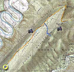
Start by passing the closed gate and heading up the orange blazed FS road that is part of Massanutten Trail. In 1.1 miles cross Little Passage Creek then in another 0.9 miles orange blazed Massanutten Trail will turn left. At this point you can either continue straight on the FS road or take the orange blazed Massanutten Trail left. They both meet on the other side of the reservoir in 0.6 miles.

After the trails meet and the FS road once again becomes the orange blazed Massanutten Trail continue for 0.3 miles and arrive at the intersection of the blue blazed Tuscarora Trail.

Turn right on the blue blazed trail immediately crossing Little Passage Creek and climbing Green Mountain, arriving at the ridge and intersection of the Meneka Peak Trail in 0.8 miles.

Turn left on the white blazed Meneka Peak Trail where the ridge line gradually ascends then descends to meet up with orange blazed Massanutten Trail in 1.0 mile.

Turn left on the orange blazed trail (also yellow blazed as the Signal Knob Trail) winding around Green Mountain and passing the transmission tower in 1.0 mile. Continue straight crossing the FS road (this is the same FS road you followed up in the beginning of the hike) and in 50 yards reach Signal Knob Lookout.

Return to the FS road turn right downhill and in 1.3 miles arrive back at the intersection of the Tuscarora Trail you took earlier. Continue straight on the orange blazed FS road retracing your route and arriving back at the parking area in another 2.0 miles.

Explore 94 trails near Fort Valley, VA

Know Before You Go

  • The Little Passage Creek Hike is a 9.5-mile loop in Fort Valley, VA, combining sections of several other Signal Knob area trails.
  • The hike follows a mix of blazed trails (orange Massanutten, blue Tuscarora, white Meneka Peak, yellow Signal Knob) and a Forestry Service (FS) road, offering varied terrain and views.
  • The route includes creek crossings, climbs to ridges, and a visit to Signal Knob Lookout, with a return via the FS road.
Interactive topographic map for Little Passage Creek Hike located in Fort Valley, VA. Click the "View Map" button to load GPS coordinates and trail markers.
Get directions
Distance
9.5 mi
Difficulty
Moderate
Type
Loop
Est. Time
4.8 hrs
Elev. Gain
1,301'
Rating
3.3
Added
February 01, 2025
Updated
April 04, 2025

Weather Forecast

Loading...
Total Change
1,170'
Ascent
1,301'
Descent
1,295'
Loading...

Download the GPX Data for Offline Use

Supporters get exclusive access to download trail routes to the MyHikes app for offline use. Stay prepared on your adventure, even without an internet connection! Become a Supporter today to unlock this feature and hike with confidence.

Download Little Passage Creek Hike GPX Data to the MyHikes Mobile App

Features

Vista / Lookout Point
Dogs
Mountain Summit
Camping

Points of interest

  1. Parking

    38.922669, -78.380558
  2. Main Trailhead

    38.922374, -78.380563

Safety information

For your own safety: plan ahead, let someone know where you'll be, and hike at your own risk.

Hazards

Snakes (Rattlesnakes, Copperheads, others)
Poison Ivy or Poison Oak

Markers

Blaze Color

Orange

Availability

All seasons

Surface type

Dirt

Trip Reports (Reviews)

Rated 3.33 out of 5 based on 3 ratings.

Ready to help fellow hikers? Add a trip report to share your experience and provide valuable insights for other hikers!

By: MKCP
9.5 miles / 15.3 km
July 28, 2018
Overall a pretty good hike - but note, when you map to the parking area, you should turn off of Boyer Road onto the fire road and keep driving the additional two miles, past the Powell's Fort Organization Camp (defunct) turnoff until you reach a gate that is closed. We turned off of Boyer Road, saw a gate, and because of the confusing points noted from the "Directions" that resulted from Google Maps, we added 2 miles walking on the fire road each way by parking at that junction, and wound up walking directly up the fire road most of the way directly to Signal Knob. We skipped the Menaka Peak and Tuscarora Trail pieces when we realized our mistake, as we hadn't brought enough water for a 14 mile hike. The good news? A stunning view, and a hike that was moderately strenuous, but well-shaded for a hot summer day.
Legacy Review
By: Nice long hike, good views
9.5 miles / 15.3 km
September 20, 2015
For a ten mile hike this wasn't too strenuous, even the ascent of Green Mountain wasn't too bad. There are a couple of decent overlooks along the ridge, but the real payoff is around the Signal Knob tower with a stunning vista view to the North. The fire road is a gravel paved road, so kind of tough on the feet if you don't have appropriate shoes. Parking is somewhat limited, but we had the trail largely to ourselves so no issue finding a place to park. Once you pass the reservoir there aren't any further opportunities to find water, so plan appropriately.
Legacy Review
By: Katherine
9.5 miles / 15.3 km
May 23, 2013
Overall I enjoyed this hike quite a bit. The Forestry road section at the beginning was a little bit boring, but once I got to the Strasburg Reservoir, it became more interesting, and overall I quite enjoyed the whole hike. There are a lot of great campsites along the way!
Legacy Review
No community routes found. To add your own hike as a Community Route for this Trail guide, leave a Trip Report with an attached GPX file.

Popular categories

Scenic mountain view representing vista trails
Vista trails
Scenic gorge of cascades representing waterfall trails
Waterfall hikes
Rugged mountain terrain representing summit trails
Summit trails
Scenic mountain view representing dog-friendly trails
Dog-friendly
Scenic campsite with a view representing camping trails
Camping trails
Appalachian Trail logo representing A.T. hikes
A.T. hikes

You May Also Like

25 Best Day Hikes in North Carolina - Discover the top 25 best day hikes in North Carolina, from breathtaking waterfalls to mountain peaks. Explore hidden gems, scenic views, and trails suitable for all skill levels, perfect for your next outdoor adventure.
Explore

25 Best Day Hikes in North Carolina

Discover the top 25 best day hikes in North Carolina, from breathtaking waterfalls to mountain peaks. Explore hidden gems, scenic views, and trails suitable for all skill levels, perfect for your next outdoor adventure.

Read
🍪 We use cookies to learn about site usage and to serve map tiles. You may block cookies manually in the browser. By continuing you agree. Learn more