Loading...

🎉 Enjoy a Free 7-Day Supporter Trial and Unlock Exclusive Perks — No Credit Card Required. Learn more.

Little Lyman Vista

Directions
Map
Pictures
Send to App
Distance:
0 Miles / 0 km
Type:
Out-and-Back
Difficulty:
Easy
Time to Hike:
~5 minutes
Features:
PA Wilds
Surface Type:
Dirt
Park:
Susquehannock State Forest
Town:
Austin, Pennsylvania
Directions:
41.604928, -77.841399
Added:
May 28, 2023
Updated:
June 09, 2023
Copy Trail Link Hiking this trail? Send a friend or family member a link to this trail guide for your own safety. Hike at your own risk (disclaimer)
Loading...

Download the Trail Route for Offline Use

Supporters get exclusive access to download trail routes to the MyHikes app for offline use. Stay prepared on your adventure, even without an internet connection! Become a Supporter today to unlock this feature and hike with confidence.

Send to App

Little Lyman Vista

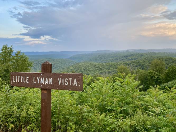
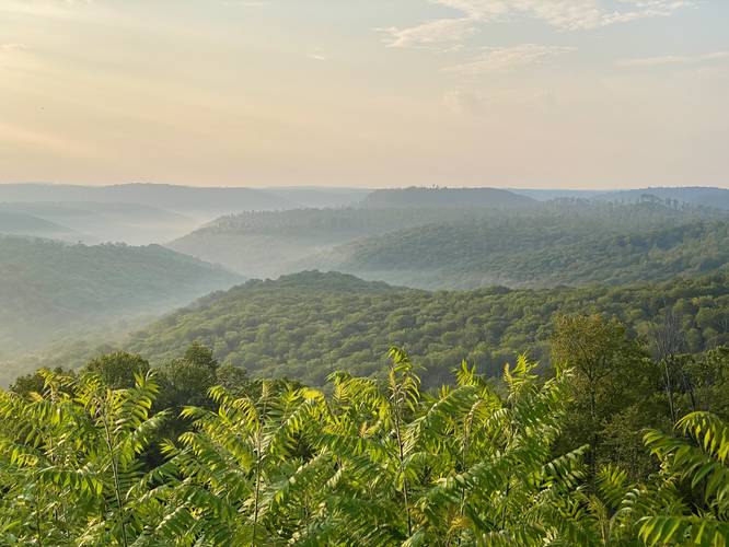
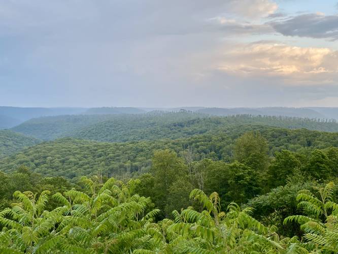
Little Lyman Vista at Susquehannock State Forest in Abbott, Pennsylvania is an accessible roadside southeast-facing view of a mountainous plateau with views of Stony Peak and Twin Top Peak.

This is not a hike and just barely a walk, but rather a few steps out of your car to take in the views of the mountains at Little Lyman Vista. As of 2022-2023 a new mountain, Stony Peak, can be seen from this vista with its logged mountain slopes and a crown of trees at its summit. Stony Peak was officially named in 2023 with the U.S. Geological Survey by MyHikes' Founder Dave Miller after he and Tony Van Vugt scouted the mountain and hiked to the summit in 2022 and named it "Stony Peak" then. This is a great spot for folks to enjoy the mountains of the PA Wilds without having to do any hiking or really any walking if they choose not to or physically can't. If you choose to walk, the distance is negligible, but there are different vantage points from each end of the parking turnout. There's also a bench at the vista.

Parking
Visitors will find parking at the coordinates provided. The turnout is large enough to fit a half-dozen vehicles at most.

Pets
Dogs are allowed if leashed and cleaned up after.

No Winter Maintenance
There's no Winter maintenance on these forest roads, so don't expect to be able to reach this vista unless on a snowmobile (if permitted) or on a very long hike.
Explore 254 trails near Austin, PA
  1. Parking

    41.604928, -77.841399
  2. Main Trailhead

    41.605002, -77.841257
  3. Little Lyman Vista

    41.604964, -77.841274
    Little Lyman Vista
No community routes found. To add your own hike as a Community Route for this Trail guide, leave a Trip Report with an attached GPX file.

Hazards

Ticks - Lyme Disease More Info (CDC)
Snakes

Seasons

All

Trip Reports

Trail Guide By:
Admin user profile picture
0 miles / 0 km
0 miles / 0 km
August 06, 2023
Stopped on our way out from camping at Stony Peak. Beautiful morning views with fog surrounding the mountain tops.
Dogs Hiking
0 miles / 0 km
August 06, 2023
Dogs Hiking
0 miles / 0 km
July 31, 2023
Great roadside vista of Stony Peak after a hike out to its summit. Caught Stony Peak surrounded by fog lifting after the rain that was dumped on us on the hike out,
Hiking

Weather Forecast

In Austin, PA

Explore Hiking Trails

You May Also Like

Colorado's Million Dollar Highway - Plan a day's drive adventure along the iconic Million Dollar Highway in Colorado. Explore the best short trails, roadside stops, waterfalls, vistas, ghost towns, and hot springs within a ~6 hour road trip.
Explore

Colorado's Million Dollar Highway

Plan a day's drive adventure along the iconic Million Dollar Highway in Colorado. Explore the best short trails, roadside stops, waterfalls, vistas, ghost towns, and hot springs within a ~6 hour road trip.

Read
New York's Best Waterfalls - Whether you're planning a day hike, roadside stop, or a leisurely short walk, this guide provides hikers, travelers, and locals alike with 63 different locations to over 100 scenic waterfalls to help plan your next adventure!
Explore

New York's Best Waterfalls

Whether you're planning a day hike, roadside stop, or a leisurely short walk, this guide provides hikers, travelers, and locals alike with 63 different locations to over 100 scenic waterfalls to help plan your next adventure!

Read

Before you boogie...

Find our trail guides useful? Consider becoming a Supporter to unlock perks!

MyHikes is an indie platform that makes exploring public trails easier for everyone. The platform has no investors, no ads, and is owned and operated by one person, Dave Miller. Dave has personally mapped and written over 1,800 trail guides on MyHikes for the public to explore. MyHikes has helped millions outdoor enthusiasts plan their next adventure.

But it takes a lot of time 🕦, money 💰, work, and espresso shots ☕ to run MyHikes, including hiking , mapping , writing , and publishing new trails with high-quality (accurate) information... along with software engineering (coding) the platform like building new features, website and mobile app development (iOS and Android), site maintainance . and much much more.

Supporters unlock website and mobile app perks with an annual one-time payment of $25 (you renew) 😎👍. Or you can simply make a Donation of your choice. Otherwise, you can support us by telling your friends about MyHikes - both quick and free 🎉

Admin user profile picture

Dave Miller
MyHikes Founder