The Little Falls Trail at Boyce Mayview Park in Upper Saint Clair, Pennsylvania is an easy 0.2-mile one-way trail that features several very small seasonal waterfalls.
Hike Description
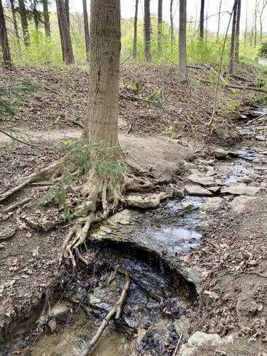
This hike begins at the western trailhead for the Little Falls Trail and heads through the ravine and over to two creeks that converge into one. Hikers, if looking for the waterfalls in these creeks, will want to show up in the very early Spring right after a heavy rainfall to see these waterfalls in action. The waterfalls here are no larger than 3-feet tall with the majority of the cascades being between 1 - 3 feet tall. For a much nicer waterfall hike to a 10-foot tall waterfall, check out the Mid-Falls Trail at the park.
Waterfalls
This trail has several very small seasonal waterfalls that are between 1 and 3 feet tall. They're more like creek cascades, than waterfalls but hikers will need to show up in the very early Spring to see these creeks flowing as they were mostly dried up by mid-to-late April in 2021.
Pets
Dogs are allowed on this trail; however they are not allowed on the Hidden Pond Trail which this trail connects to on the eastern terminus.
Biking
Biking is not allowed along this trail.
Parking
Hikers will find parking at the coordinates provided along Birds Meadow Drive, right off of Boyce Road in Upper St. Clair. The parking lot is large enough to fit about a dozen vehicles.
Wildflowers
During the Spring (approx. mid-April) this trail usually has some nice wildflowers like Trout Lily and Trillium.
Trail Connections
This trail connects with the Hidden Pond Trail.
Hike Description
This hike begins at the western trailhead for the Little Falls Trail and heads through the ravine and over to two creeks that converge into one. Hikers, if looking for the waterfalls in these creeks, will want to show up in the very early Spring right after a heavy rainfall to see these waterfalls in action. The waterfalls here are no larger than 3-feet tall with the majority of the cascades being between 1 - 3 feet tall. For a much nicer waterfall hike to a 10-foot tall waterfall, check out the Mid-Falls Trail at the park.
Waterfalls
This trail has several very small seasonal waterfalls that are between 1 and 3 feet tall. They're more like creek cascades, than waterfalls but hikers will need to show up in the very early Spring to see these creeks flowing as they were mostly dried up by mid-to-late April in 2021.
Pets
Dogs are allowed on this trail; however they are not allowed on the Hidden Pond Trail which this trail connects to on the eastern terminus.
Biking
Biking is not allowed along this trail.
Parking
Hikers will find parking at the coordinates provided along Birds Meadow Drive, right off of Boyce Road in Upper St. Clair. The parking lot is large enough to fit about a dozen vehicles.
Wildflowers
During the Spring (approx. mid-April) this trail usually has some nice wildflowers like Trout Lily and Trillium.
Trail Connections
This trail connects with the Hidden Pond Trail.