Loading...

🔥 End of Summer sale! 50% off on Supporter Accounts — now through September 1st. Learn More.

Little Devils Stairs Hike

Directions
Map
Pictures
Send to App
Distance:
5.3 Miles / 8.5 km
Type:
Loop
Difficulty:
Moderate
Time to Hike:
2 hours, ~39 minutes
Features:
Surface Type:
Dirt
Park:
Shenandoah National Park
Town:
Washington, Virginia
Directions:
38.730453, -78.258496
Added:
March 18, 2025
Updated:
April 05, 2025
Guide by:
Copy Trail Link Hiking this trail? Send a friend or family member a link to this trail guide for your own safety. Hike at your own risk (disclaimer)
Loading...
Loading...
1,497'

Total Change
1,506'

Ascent
1,500'

Descent

Download the Trail Route for Offline Use

Supporters get exclusive access to download trail routes to the MyHikes app for offline use. Stay prepared on your adventure, even without an internet connection! Become a Supporter today to unlock this feature and hike with confidence.

Send to App

Little Devils Stairs Hike

Because of the steep grade the first two miles of the Little Devils Stairs hike in the Shenandoah National Park can be tough if the day is warm. The best time to do this hike is the early spring when water levels are at a peak, making the numerous waterfalls along Keiser Run that much nicer. At one point the trail even passes through a small set of falls. Enjoy spectacular views of either side of the gorge as the Little Devils Stairs trail gets closer to the top of the gorge.

The second half of the hike follows the Keyser Run Fire Road back down past the Bolen Cemetery. This is a pleasant walk through some old growth. If you would like to make this hike longer add the 3 sections of the Piney Branch hike to make the circuit a little over 9.0 miles.

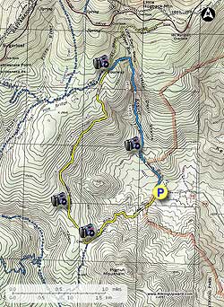
  • Mile 0.0 –The hike will begin up the right side of the parking area on the blue blazed Little Devils Stairs Trail. After 0.9 miles the grade will increase sharply as the trail climbs the ravine, and starts crisscrossing Keyser Run.

    The Little Devils Stairs Trail is hard to spot in places and you have to look for the blue blazes on the trees. However, if you believe you've lost the trail it's difficult to go too far off track, as the gorge is very narrow and trail runs along one side or the other of the stream. As you climb up the gorge there are several spots that require hand over hand climbing.

    Near the top of the ravine The Little Devils Stairs Trail becomes less steep, then makes several switchbacks before leveling off completely and arriving at the intersection of the Keyser Run Fire Road, and four way junction.

  • Mile 2.2 - Turn left down the yellow blazed Keyser Run Fire Road and in 2.0 miles enter an old hemlock forest before arriving at the Bolen Cemetery and intersection of the for the the Hull School Trail.

  • Mile 4.8 - Stay left down the yellow blazed Keyser Run Fire road where it becomes steeper for the final 1.2 miles back to the parking area.

  • Mile 5.3 - Arrive back at the parking area.
Explore 93 trails near Washington, VA
  1. Parking

    38.730453, -78.258496
  2. Main Trailhead

    38.730569, -78.258169
No community routes found. To add your own hike as a Community Route for this Trail guide, leave a Trip Report with an attached GPX file.

Hazards

Ticks - Lyme Disease More Info (CDC)
Snakes
Poison Ivy/Oak

Seasons

All

Trip Reports (Reviews)

Rated 4.16 out of 5 based on 115 ratings.
By: Chris
5.3 miles / 8.5 km
May 22, 2019
Great hike with nice views of stream and small waterfalls throughout. Not as tough as I expected. When I got to the top of the trail at the fire road I made a right and continued a mile to Skyline Drive before turning back down the fire road back to the parking lot.
Legacy Review
By: Madeleine
5.3 miles / 8.5 km
October 28, 2018
Beautiful hike, especially in October with the changing leaves. It was steep but doable and crossing the waterfall so many times was a treat. There wasn’t an overlook at the top- the hike itself was the view. However, once we turned onto the yellow blazed trail, there was an overlook a little ways down. We’ll be back!
Legacy Review
By: Jackie
5.3 miles / 8.5 km
August 26, 2018
Did Little Devil Stairs to Pine Top to Piney Branch for an ~8 mile, 2,100 feet of elevation change loop. Just a warning, with all the summer rain, all the trails were very wet yesterday! Could have benefitted from waterproof shoes to make crossings easier, but rock hopping is still mostly possible. Took of shoes to cross on Piney Branch both times. Great loop, nice gradual downhills and fun uphill scrambles! Would recommend taking Pine Top/Piney Branch alternative down for those who want to add a little extra, trail is wet but overall is a good walk. There is a nice climb from about mile 6-7 though, but its all downhill after that!
Legacy Review

Weather Forecast

In Washington, VA

Explore Hiking Trails

You May Also Like

New York's Best Waterfalls - Whether you're planning a day hike, roadside stop, or a leisurely short walk, this guide provides hikers, travelers, and locals alike with 63 different locations to over 100 scenic waterfalls to help plan your next adventure!
Explore

New York's Best Waterfalls

Whether you're planning a day hike, roadside stop, or a leisurely short walk, this guide provides hikers, travelers, and locals alike with 63 different locations to over 100 scenic waterfalls to help plan your next adventure!

Read
25 Best Day Hikes in North Carolina - Discover the top 25 best day hikes in North Carolina, from breathtaking waterfalls to mountain peaks. Explore hidden gems, scenic views, and trails suitable for all skill levels, perfect for your next outdoor adventure.
Explore

25 Best Day Hikes in North Carolina

Discover the top 25 best day hikes in North Carolina, from breathtaking waterfalls to mountain peaks. Explore hidden gems, scenic views, and trails suitable for all skill levels, perfect for your next outdoor adventure.

Read

Before you boogie...

Find our trail guides useful? Consider becoming a Supporter to unlock perks!

MyHikes is an indie platform that makes exploring public trails easier for everyone. The platform has no investors, no ads, and is owned and operated by one person, Dave Miller. Dave has personally mapped and written over 1,800 trail guides on MyHikes for the public to explore. MyHikes has helped millions outdoor enthusiasts plan their next adventure.

But it takes a lot of time 🕦, money 💰, work, and espresso shots ☕ to run MyHikes, including hiking , mapping , writing , and publishing new trails with high-quality (accurate) information... along with software engineering (coding) the platform like building new features, website and mobile app development (iOS and Android), site maintainance . and much much more.

Supporters unlock website and mobile app perks with an annual one-time payment of $25 (you renew) 😎👍. Or you can simply make a Donation of your choice. Otherwise, you can support us by telling your friends about MyHikes - both quick and free 🎉

Admin user profile picture

Dave Miller
MyHikes Founder