Loading...

🎉 Enjoy a Free 7-Day Supporter Trial and Unlock Exclusive Perks — No Credit Card Required. Learn more.

Little Crease Mountain Hike

Directions
Map
Pictures
Send to App
Distance:
8.9 Miles / 14.3 km
Type:
Out-and-Back
Difficulty:
Hard
Time to Hike:
4 hours, ~27 minutes
Features:
Surface Type:
Dirt
Park:
George Washington National Forest
Town:
Fort Valley, Virginia
Directions:
38.929569, -78.328209
Added:
February 01, 2025
Updated:
April 04, 2025
Copy Trail Link Hiking this trail? Send a friend or family member a link to this trail guide for your own safety. Hike at your own risk (disclaimer)
Loading...
Loading...
1,428'

Total Change
2,100'

Ascent
2,100'

Descent

Download the Trail Route for Offline Use

Supporters get exclusive access to download trail routes to the MyHikes app for offline use. Stay prepared on your adventure, even without an internet connection! Become a Supporter today to unlock this feature and hike with confidence.

Send to App

Little Crease Mountain Hike

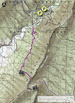
One of several hikes in the Elizabeth Furnace area, the Little Crease Mountain out and back follows the Sherman Gap trail, then heads south along the Tuscarora/Massanutten trail with 360° views of High Peak and Buzzard Rock to the north. After passing the high point the Tuscarora/Massanutten Trail descends along Shenandoah Mountain to the hike turn around with a beautiful overlook of the South Fork of the Shenandoah River and campsite.

If you wish to hike this as a backpack there are two good camping sites. The first is at the intersection of the Sherman Gap Trail and Tuscarora/Massanutten trails, and the second is on the Shenandoah Mountain ridge at the turn around point for the hike. This second campsite has excellent views of the Luray Valley and Shenandoah National Park.

  • Mile 0.0 – From the parking area before crossing Passage Creek follow the road towards the picnic day use area. Cross Passage Creek and pass the gate. In 60 yards the road will split with the orange and blue blazed Tuscarora/Massanutten Trail going left. Stay right and follow the road into the main parking area. (Park here if the gate at Passage Creek is open).
  • Mile 0.16 - At the far left end of of the parking area look for the white blazed connector trail and trailhead kiosk. Follow the trail through the picnic area and shortly arrive at Passage Creek.
  • Mile 0.34 - Turn left following Passage Creek on the white blazed trail. There are several good spots to walk down to the creek and take a break. In 0.5 miles the trail will head slightly uphill away from Passage Creek, then in another 0.16 miles the trail ends at the intersection the Sherman Gap Trail.
  • Mile 1.0 - Located at the Sherman Gap Trail intersection is a memorial plaque honoring 'R. Wayne Botts, Lifetime Trail Builder'. Turn left on the pink blazed Sherman Gap Trail uphill. The Sherman Gap Trail will pass through seven gullies as it winds around the mountain to the south, and when the trees are bare there are intermittent views of Fort Valley. After 2.1 miles make a switchback to the north. Pass a unique stone formation, then the last 0.5 miles to the ridge is the steepest section in the hike.
  • Mile 3.53 - At the ridge the pink blazed Sherman Gap Trail turns right joining the blue and orange blazed Tuscarora/Massanutten. This short section of trail is one of the few trails on the east coast that is blazed with 3 colors. Turn right at the ridge on the Sherman/Tuscarora/Massanutten trail and pass a campsite on the right. Descend to the gap and intersection where the pink blazed Sherman Gap trail turns downhill to the left.
  • Mile 3.65 - Stay straight, and proceed upward following the ridge on the blue and orange blazed Tuscarora/Massanutten trail as it climbs Little Crease Mountain. Follow the trail around to the left and pass an interesting rock formation on the right. The trail will then arrive at the ridge between Little Crease and Shenandoah mountains. Along this section of trail are views north of High Peak and Shenandoah Mountain. Continue along the trail for another 0.1 miles to the point the trail begins to descend. There are a 360° views here. Continue downhill on the blue and orange blazed trail, then soon turn south on Shenandoah Mountain arriving at the hike turn around point in another 0.2 miles.
  • Mile 4.45 - The turn turn around for the hike is marked by a campsite and beautiful overlook of the South Fork of the Shenandoah river and valley. Follow your route back to the parking area at Elizabeth Furnace.
  • Mile 8.9 - Arrive back at the Elizabeth Furnace parking area.
Explore 92 trails near Fort Valley, VA
  1. Parking

    38.929569, -78.328209
  2. Main Trailhead

    38.929643, -78.328185
No community routes found. To add your own hike as a Community Route for this Trail guide, leave a Trip Report with an attached GPX file.

Hazards

Ticks - Lyme Disease More Info (CDC)
Snakes

Seasons

All

Blaze Color

Pink

Trip Reports

Trail Guide By:
HikingUpward user profile picture
8.9 miles / 14.3 km

Weather Forecast

In Fort Valley, VA

Explore Hiking Trails

You May Also Like

New York's Best Waterfalls - Whether you're planning a day hike, roadside stop, or a leisurely short walk, this guide provides hikers, travelers, and locals alike with 63 different locations to over 100 scenic waterfalls to help plan your next adventure!
Explore

New York's Best Waterfalls

Whether you're planning a day hike, roadside stop, or a leisurely short walk, this guide provides hikers, travelers, and locals alike with 63 different locations to over 100 scenic waterfalls to help plan your next adventure!

Read
25 Best Day Hikes in North Carolina - Discover the top 25 best day hikes in North Carolina, from breathtaking waterfalls to mountain peaks. Explore hidden gems, scenic views, and trails suitable for all skill levels, perfect for your next outdoor adventure.
Explore

25 Best Day Hikes in North Carolina

Discover the top 25 best day hikes in North Carolina, from breathtaking waterfalls to mountain peaks. Explore hidden gems, scenic views, and trails suitable for all skill levels, perfect for your next outdoor adventure.

Read

Before you boogie...

Find our trail guides useful? Consider becoming a Supporter to unlock perks!

MyHikes is an indie platform that makes exploring public trails easier for everyone. The platform has no investors, no ads, and is owned and operated by one person, Dave Miller. Dave has personally mapped and written over 1,800 trail guides on MyHikes for the public to explore. MyHikes has helped millions outdoor enthusiasts plan their next adventure.

But it takes a lot of time 🕦, money 💰, work, and espresso shots ☕ to run MyHikes, including hiking , mapping , writing , and publishing new trails with high-quality (accurate) information... along with software engineering (coding) the platform like building new features, website and mobile app development (iOS and Android), site maintainance . and much much more.

Supporters unlock website and mobile app perks with an annual one-time payment of $25 (you renew) 😎👍. Or you can simply make a Donation of your choice. Otherwise, you can support us by telling your friends about MyHikes - both quick and free 🎉

Admin user profile picture

Dave Miller
MyHikes Founder