Loading...

🎉 Enjoy a Free 7-Day Supporter Trial and Unlock Exclusive Perks — No Credit Card Required. Learn more.

Laurel Run and Gusty Point Hike

Directions
Map
Pictures
Send to App
Distance:
7.5 Miles / 12.1 km
Type:
Loop
Difficulty:
Moderate
Time to Hike:
3 hours, ~45 minutes
Features:
Surface Type:
Dirt
Park:
George Washington National Forest
Town:
Basye, Virginia
Directions:
38.890714, -78.732319
Added:
February 01, 2025
Updated:
April 04, 2025
Copy Trail Link Hiking this trail? Send a friend or family member a link to this trail guide for your own safety. Hike at your own risk (disclaimer)
Loading...
Loading...
1,668'

Total Change
1,981'

Ascent
1,966'

Descent

Download the Trail Route for Offline Use

Supporters get exclusive access to download trail routes to the MyHikes app for offline use. Stay prepared on your adventure, even without an internet connection! Become a Supporter today to unlock this feature and hike with confidence.

Send to App

Laurel Run and Gusty Point Hike

The Laurel Run/Stack Rocks circuit has some of the best views in the area. The panoramic views along orange blazed North Mountain Trail and from Gusty Point are spectacular on a clear day. If the first gate is closed just before Laurel Run you will have to park just before crossing Laurel Run. The hike will be 8.8 miles long from this point. If the gate is open you can avoid the extra out and back on FDR252 by parking 1.1 miles further at the yellow blazed Laurel Run Trail entrance reducing the hike to 6.6 miles.

The hike to Gusty Point can also be done as as an easy 1.5 mile out and back hike from the parking area on FR 691, 0.1 miles from the North Mountain trailhead. 38.927119, -78.737627

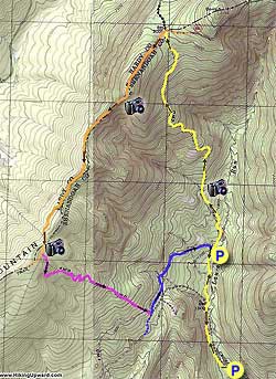
If you park a the first gate start the hike by walking 1.1 miles up FDR252 before arriving at the start of the loop where the closed gate and yellow blazed Laurel Run Trail turns to your right.

Start up the yellow blazed trail and in one hundred yards arrive at a split in the trail. Bear left continuing up yellow blazed Laurel Run Trail for 2.1 miles. The trail will pass through two wildlife clearings before winding back and forth becoming steeper as it gets close to the mountain ridge. Just before reaching the junction of the North Mountain Trail, Laurel Run Trail will pass a small pond on your left.

Arrive at the junction of the North Mountain Trail and a forestry service road. Orange blazed North Mountain Trail will turn left. Take the orange blazed trail for 0.7 miles and look for a white blazed side trail that will take you to the Gusty Point Overlook.

Continue for another 1.6 miles as the orange blazed trail crosses over two more knolls on the mountain before arriving at the junction of the purple blazed Stack Rocks Trail.

Turn left downhill on the purple blazed Stack Rocks Trail as it winds steeply downhill for 1.3 miles before arriving at the junction of the blue blazed FDR252 road.

Turn left on blue blazed FDR252 for 0.9 miles as it winds back around the valley to the starting point of the loop and yellow blazed Laurel Run Trail on your left.

If you had to park at the lower parking area continue down FDR252 for the remaining 1.1 miles back to the lower parking area.

Explore 80 trails near Basye, VA
  1. Parking

    38.890714, -78.732319
  2. Main Trailhead

    38.890714, -78.732319
No community routes found. To add your own hike as a Community Route for this Trail guide, leave a Trip Report with an attached GPX file.

Hazards

Ticks - Lyme Disease More Info (CDC)
Snakes
Poison Ivy/Oak

Seasons

All

Weather Forecast

In Basye, VA

Explore Hiking Trails

You May Also Like

New York's Best Waterfalls - Whether you're planning a day hike, roadside stop, or a leisurely short walk, this guide provides hikers, travelers, and locals alike with 63 different locations to over 100 scenic waterfalls to help plan your next adventure!
Explore

New York's Best Waterfalls

Whether you're planning a day hike, roadside stop, or a leisurely short walk, this guide provides hikers, travelers, and locals alike with 63 different locations to over 100 scenic waterfalls to help plan your next adventure!

Read
25 Best Day Hikes in North Carolina - Discover the top 25 best day hikes in North Carolina, from breathtaking waterfalls to mountain peaks. Explore hidden gems, scenic views, and trails suitable for all skill levels, perfect for your next outdoor adventure.
Explore

25 Best Day Hikes in North Carolina

Discover the top 25 best day hikes in North Carolina, from breathtaking waterfalls to mountain peaks. Explore hidden gems, scenic views, and trails suitable for all skill levels, perfect for your next outdoor adventure.

Read

Before you boogie...

Find our trail guides useful? Consider becoming a Supporter to unlock perks!

MyHikes is an indie platform that makes exploring public trails easier for everyone. The platform has no investors, no ads, and is owned and operated by one person, Dave Miller. Dave has personally mapped and written over 1,800 trail guides on MyHikes for the public to explore. MyHikes has helped millions outdoor enthusiasts plan their next adventure.

But it takes a lot of time 🕦, money 💰, work, and espresso shots ☕ to run MyHikes, including hiking , mapping , writing , and publishing new trails with high-quality (accurate) information... along with software engineering (coding) the platform like building new features, website and mobile app development (iOS and Android), site maintainance . and much much more.

Supporters unlock website and mobile app perks with an annual one-time payment of $25 (you renew) 😎👍. Or you can simply make a Donation of your choice. Otherwise, you can support us by telling your friends about MyHikes - both quick and free 🎉

Admin user profile picture

Dave Miller
MyHikes Founder