Loading...

WINTER SALE! 50% OFF Supporter Accounts — now through January 31st. Learn More.

Larb Hollow Vista Point

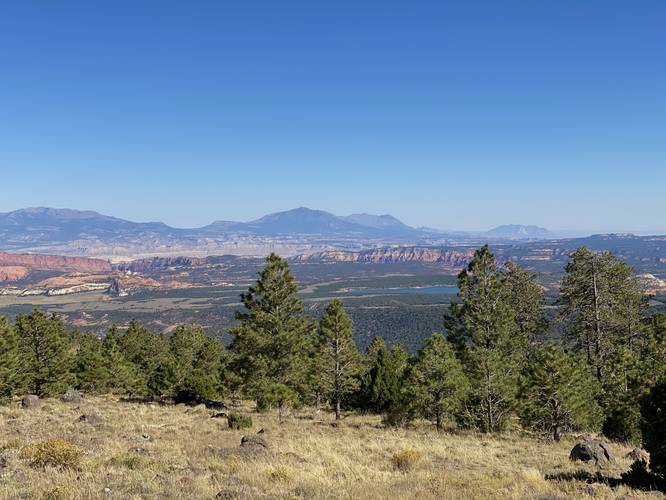
The Larb Hollow Vista Point at Dixie National Forest near Grover, Utah is an easy universally-accessible vista that features southward views of the Lower Bowns Reservoir and surrounding mountains.

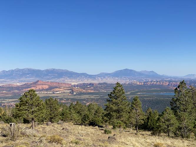
This is not a hike, but rather a quick roadside stop that can be enjoyed on a long road trip through southern Utah. Visitors will find sweeping views facing southward mostly of the Lower Bowns Reservoir but also the surrounding mountains, mesas, and buttes. The main point-of-interest within the view here is the Lower Bowns Reservoir which is located directly south -- simply look for the large body of blue water out in the middle of the Utah desert.

Universal Access
This walk follows a paved and universally-accessible pathway.

Parking
Visitors will find a large parking lot at the coordinates provided.

Pets
Dogs are allowed if leashed and must be cleaned up after.
Explore 24 trails near Grover, UT

Know Before You Go

  • Larb Hollow Vista Point offers accessible, scenic views of Lower Bowns Reservoir and surrounding landscape directly from a roadside stop.
  • It's a quick, universally-accessible, paved stop near Grover, Utah within Dixie National Forest, ideal for breaking up a road trip.
  • The vista point has a parking lot and allows leashed dogs if owners clean up after them.
Interactive topographic map for Larb Hollow Vista Point located in Grover, UT. Click the "View Map" button to load GPS coordinates and trail markers.
Get directions
Distance
N / A
Difficulty
Easy
Type
Out-and-Back
Est. Time
5 min
Elev. Gain
3'
Rating
0.0
Added
September 26, 2023
Updated
October 04, 2023

Weather Forecast

Loading...

Features

Vista / Lookout Point
Dogs

Points of interest

  1. Parking

    38.13244, -111.325886
  2. Main Trailhead

    38.13244, -111.325886

Safety information

For your own safety: plan ahead, let someone know where you'll be, and hike at your own risk.

Hazards

Snakes (Rattlesnakes, Copperheads, others)

Availability

All seasons

Surface type

Universal Access

Trip Reports (Reviews)

Your opinion matters! Be the first to rate this trail.

Ready to help fellow hikers? Add a trip report to share your experience and provide valuable insights for other hikers!

0 miles / 0 km
September 26, 2023
Hiking
No community routes found. To add your own hike as a Community Route for this Trail guide, leave a Trip Report with an attached GPX file.

Popular categories

Scenic mountain view representing vista trails
Vista trails
Scenic gorge of cascades representing waterfall trails
Waterfall hikes
Rugged mountain terrain representing summit trails
Summit trails
Scenic mountain view representing dog-friendly trails
Dog-friendly
Scenic campsite with a view representing camping trails
Camping trails
Appalachian Trail logo representing A.T. hikes
A.T. hikes

You May Also Like

Colorado's Million Dollar Highway - Plan a day's drive adventure along the iconic Million Dollar Highway in Colorado. Explore the best short trails, roadside stops, waterfalls, vistas, ghost towns, and hot springs within a ~6 hour road trip.
Explore

Colorado's Million Dollar Highway

Plan a day's drive adventure along the iconic Million Dollar Highway in Colorado. Explore the best short trails, roadside stops, waterfalls, vistas, ghost towns, and hot springs within a ~6 hour road trip.

Read
Glacier's Going-to-the-Sun Road - Discover the breathtaking beauty of Glacier National Park along the iconic Going-to-the-Sun Road. From stunning roadside stops to picturesque waterfalls and vistas, this engineering marvel offers endless opportunities for exploration.
Explore

Glacier's Going-to-the-Sun Road

Discover the breathtaking beauty of Glacier National Park along the iconic Going-to-the-Sun Road. From stunning roadside stops to picturesque waterfalls and vistas, this engineering marvel offers endless opportunities for exploration.

Read
🍪 We use cookies to learn about site usage and to serve map tiles. You may block cookies manually in the browser. By continuing you agree. Learn more