Loading...

🍁 Fall is here! Check out our foliage map to plan your autumn hikes! Learn more.

Lambs Creek Graffiti Bridge Trail

Directions
Map
Pictures
Send to App
Distance:
0.7 Miles / 1.1 km
Type:
Out-and-Back
Difficulty:
Easy
Time to Hike:
~21 minutes
Features:
PA Wilds
Surface Type:
Paved
Park:
Lambs Creek Recreation Area
Town:
Mansfield, Pennsylvania
Get Directions:
41.839501, -77.107566
Added:
September 09, 2019
Updated:
June 02, 2020
Copy Trail Link Hiking this trail? Send a friend or family member a link to this trail guide for your own safety. Hike at your own risk (disclaimer)
Loading...
Loading...
38'

Total Change
41'

Ascent
40'

Descent

Download the Trail Route for Offline Use

Supporters get exclusive access to download trail routes to the MyHikes app for offline use. Stay prepared on your adventure, even without an internet connection! Become a Supporter today to unlock this feature and hike with confidence.

Send to App

Key Takeaways

  • The Lambs Creek Graffiti Bridge Trail is a short, easy 0.7-mile hike to a colorful, graffiti-covered bridge over the Tioga River.
  • The trail is popular due to its accessibility, scenic views, and the unique art on the bridge.
  • Visitors should be aware of parking limitations, leash their dogs, be mindful of apiaries, and can connect to the Hike & Bike Trail via the bridge.

Lambs Creek Graffiti Bridge Trail

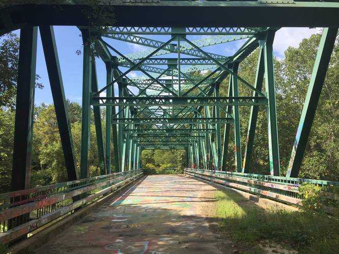
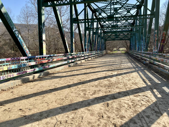
The Lambs Creek Graffiti Bridge Trail at Lambs Creek Recreation Area in Mansfield, Pennsylvania is an easy 0.7-mile out-and-back trail that leads hikers to a decommissioned and well-graffitied bridge that sits above the Tioga River.

This short trail is an old road that was once used to cross the Tioga River at Lambs Creek Recreation Area, but is now closed. Since its closure, local angst-y teens and other folk have decided to decorate the bridge with words of wisdom, Spongebob caricatures, and other colorful artsy designs.

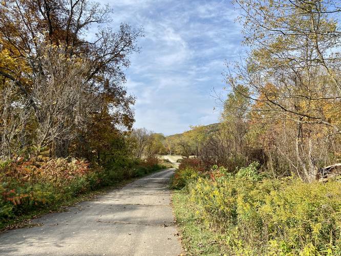
While this is just a short trail, it's one of the more popular spots to hike near Mansfield PA due to the ease of access, views heading down to the bridge, and the colorful bridge itself.

Visitors can also access the Hike & Bike Trail at Lambs Creek, which connects to the bridge.

Parking
Visitors can find parking at the coordinates provided for a quick and easy hike to the bridge. Do not block the gate in case park personnel need to access the road; however, there should be enough space for a few cars to pull of the road near the entrance gate.

Pets
Dogs are allowed if leashed and their waste must be carried out by the hiker.

Biking
Biking is allowed on this trail and you can connect to the Hike & Bike Trail on the other side of the bridge.

Apiaries
Hikers can find apiaries along the trail - do not disturb these hives since their survival plays a critical role in keeping Lambs Creek's ecosystem in check.

Views
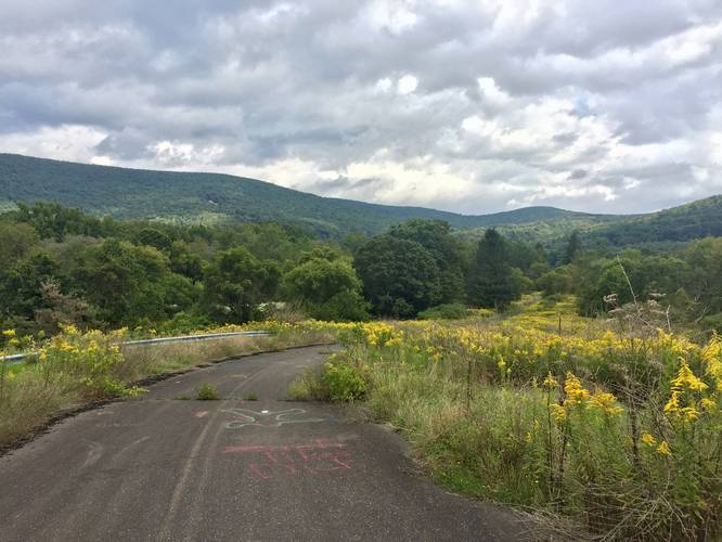
Along the western side of the trail, as it makes its way downhill toward the bridge, are views of the surrounding mountains. This side of the trail is especially beautiful during the late Summer when Golden Rod fill the fields along the trail.
Explore 252 trails near Mansfield, PA
  1. Parking

    41.839501, -77.107566
  2. Main Trailhead

    41.839554, -77.10758
  3. View / Overlook / Vista

    41.839967, -77.107431
    View / Overlook / Vista
  4. Lamsb Creek Graffiti Bridge

    41.841667, -77.102897
    Lamsb Creek Graffiti Bridge
No community routes found. To add your own hike as a Community Route for this Trail guide, leave a Trip Report with an attached GPX file.

Hazards

Ticks - Lyme Disease More Info (CDC)

Seasons

All

Photo Albums

+ Add Photo Album

Upload your photos from the trail to help others know what to expect.

View All Photo Albums
Preview of the MyHikes mobile app interface

Track, Log, and Explore Hikes with the MyHikes App

Explore Autumn Foliage

No Change
Some Color
Low Color
Moderate Color
High Color
Peak Color
Past Peak
Sept 1 Sept 8 Sept 15 Sept 22 Sept 29 Oct 6 Oct 13 Oct 20 Oct 27 Nov 3 Nov 10 Nov 17 Nov 24
Shop Landscape Prints
Shop our landscape prints from the Grand Canyon of Pennsylvania

Trip Reports (Reviews)

Ready to help fellow hikers? Add a trip report to share your experience and provide valuable insights for those planning their next hike. Your review makes the trail better for everyone.

Your opinion matters! Be the first to rate this trail.
0.7 miles / 1.1 km
June 23, 2023
Hiking
0.7 miles / 1.1 km
March 21, 2022
Hiking
0.7 miles / 1.1 km
March 21, 2022
Hiking

Weather Forecast

In Mansfield, PA

Explore Hiking Trails

You May Also Like

Colorado's Million Dollar Highway - Plan a day's drive adventure along the iconic Million Dollar Highway in Colorado. Explore the best short trails, roadside stops, waterfalls, vistas, ghost towns, and hot springs within a ~6 hour road trip.
Explore

Colorado's Million Dollar Highway

Plan a day's drive adventure along the iconic Million Dollar Highway in Colorado. Explore the best short trails, roadside stops, waterfalls, vistas, ghost towns, and hot springs within a ~6 hour road trip.

Read
New York's Best Waterfalls - Whether you're planning a day hike, roadside stop, or a leisurely short walk, this guide provides hikers, travelers, and locals alike with 63 different locations to over 100 scenic waterfalls to help plan your next adventure!
Explore

New York's Best Waterfalls

Whether you're planning a day hike, roadside stop, or a leisurely short walk, this guide provides hikers, travelers, and locals alike with 63 different locations to over 100 scenic waterfalls to help plan your next adventure!

Read

Before you boogie...

Find our trail guides useful? Consider becoming a Supporter to unlock perks!

MyHikes is an indie platform that makes exploring public trails easier for everyone. The platform has no investors, no ads, and is owned and operated by one person, Dave Miller. Dave has personally mapped and written over 1,800 trail guides on MyHikes for the public to explore. MyHikes has helped millions outdoor enthusiasts plan their next adventure.

But it takes a lot of time 🕦, money 💰, work, and espresso shots ☕ to run MyHikes, including hiking , mapping , writing , and publishing new trails with high-quality (accurate) information... along with software engineering (coding) the platform like building new features, website and mobile app development (iOS and Android), site maintainance . and much much more.

Supporters unlock website and mobile app perks with an annual one-time payment of $25 (you renew) 😎👍. Or you can simply make a Donation of your choice. Otherwise, you can support us by telling your friends about MyHikes - both quick and free 🎉

Admin user profile picture

Dave Miller
MyHikes Founder