Loading...

🎉 Enjoy a Free 7-Day Supporter Trial and Unlock Exclusive Perks — No Credit Card Required. Learn more.

Lake Moomaw Hike

Directions
Map
Pictures
Send to App
Distance:
5.6 Miles / 9.0 km
Type:
Out-and-Back
Difficulty:
Moderate
Time to Hike:
2 hours, ~48 minutes
Features:
Surface Type:
Dirt
Park:
George Washington National Forest
Town:
Alleghany County, Virginia
Directions:
37.975111, -79.984786
Added:
February 01, 2025
Updated:
April 04, 2025
Copy Trail Link Hiking this trail? Send a friend or family member a link to this trail guide for your own safety. Hike at your own risk (disclaimer)
Loading...
Loading...
312'

Total Change
1,501'

Ascent
1,496'

Descent

Download the Trail Route for Offline Use

Supporters get exclusive access to download trail routes to the MyHikes app for offline use. Stay prepared on your adventure, even without an internet connection! Become a Supporter today to unlock this feature and hike with confidence.

Send to App

Lake Moomaw Hike

Lake Moomaw, in the Allegheny Highlands, is created by the Gathright Dam that backs up the Jackson River for over 12 miles. The dam and lake were completed by the Army Corps of Engineers in the early 1980's, and was designed to provide flood control and recreation including miles of hiking trails that surround the lake. The lake is a popular area for boaters, and many people also canoe from Campground 3 out to the Greenwood Point Campground.

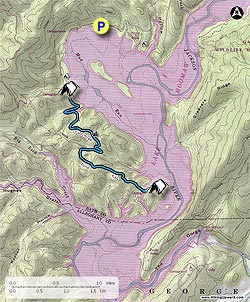
The out and back hike starts at the main parking area and beach passing the two tent camp areas Bolar Mountain 1 & 2. We highly recommend Lake Moomaw as a car camping location where you can not only hike the trails, but also swim, fish and enjoy other water sports.

Camping during the Off Season - Starting Labor Day: Campgrounds 2 and 3 closed. If you are backpacking, first stop at the marina to pay to camp and hang the pass on the car rearview mirror.

  • Mile 0.0 - From the trailhead next to the first camp spot of Bolar Mountain Campground 3 head up the blue blazed Greenwood Point Trail for 0.2 miles where the trail will make a turn back through the first of several gullies. Cross a small creek and turn back passing over a spur, then descend again through another gully before the steepest climb of 0.2 miles to the hike high point, and beautiful vista of Lake Moomaw.
  • Mile 1.1 - From the high point descend for 0.4 miles crossing a stream over a wooden footbridge, then steeply ascend a spur for 0.2 miles to the intersection of an older section of the Greenwood Point Trail.

  • Mile 1.9 - Continue left on the older section of trail. From here the variance in grade is considerably less for the remaining 1.3 miles to the Greenwood Point Campground.

  • Mile 3.2 - Arrive at the the Greenwood Point Campground. A privy is located nearby.

  • Mile 5.6 - Retrace your route and return to the parking area.

Explore 30 trails near Alleghany County, VA
  1. Parking

    37.975111, -79.984786
  2. Main Trailhead

    37.975022, -79.984739
No community routes found. To add your own hike as a Community Route for this Trail guide, leave a Trip Report with an attached GPX file.

Hazards

Ticks - Lyme Disease More Info (CDC)
Snakes
Poison Ivy/Oak

Seasons

All

Blaze Color

Blue

Trip Reports

Trail Guide By:
HikingUpward user profile picture
5.6 miles / 9.0 km

Weather Forecast

In Alleghany County, VA

Explore Hiking Trails

You May Also Like

New York's Best Waterfalls - Whether you're planning a day hike, roadside stop, or a leisurely short walk, this guide provides hikers, travelers, and locals alike with 63 different locations to over 100 scenic waterfalls to help plan your next adventure!
Explore

New York's Best Waterfalls

Whether you're planning a day hike, roadside stop, or a leisurely short walk, this guide provides hikers, travelers, and locals alike with 63 different locations to over 100 scenic waterfalls to help plan your next adventure!

Read
25 Best Day Hikes in North Carolina - Discover the top 25 best day hikes in North Carolina, from breathtaking waterfalls to mountain peaks. Explore hidden gems, scenic views, and trails suitable for all skill levels, perfect for your next outdoor adventure.
Explore

25 Best Day Hikes in North Carolina

Discover the top 25 best day hikes in North Carolina, from breathtaking waterfalls to mountain peaks. Explore hidden gems, scenic views, and trails suitable for all skill levels, perfect for your next outdoor adventure.

Read

Before you boogie...

Find our trail guides useful? Consider becoming a Supporter to unlock perks!

MyHikes is an indie platform that makes exploring public trails easier for everyone. The platform has no investors, no ads, and is owned and operated by one person, Dave Miller. Dave has personally mapped and written over 1,800 trail guides on MyHikes for the public to explore. MyHikes has helped millions outdoor enthusiasts plan their next adventure.

But it takes a lot of time 🕦, money 💰, work, and espresso shots ☕ to run MyHikes, including hiking , mapping , writing , and publishing new trails with high-quality (accurate) information... along with software engineering (coding) the platform like building new features, website and mobile app development (iOS and Android), site maintainance . and much much more.

Supporters unlock website and mobile app perks with an annual one-time payment of $25 (you renew) 😎👍. Or you can simply make a Donation of your choice. Otherwise, you can support us by telling your friends about MyHikes - both quick and free 🎉

Admin user profile picture

Dave Miller
MyHikes Founder