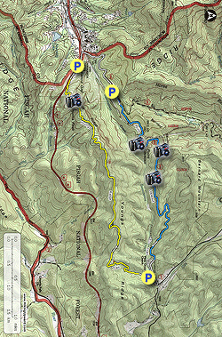
This hike utilizes two popular Pisgah National Forest trails between Black Mountain and Old Fort, NC to circumnavigate the Royal Gorge of Swannanoa Creek. Frequently used by hikers, trail runners, and mountain bikers, you will never be alone on this hike. The tradeoff for this lack of isolation is easy navigation, well-maintained trails, and good views throughout. Starting at the Old Fort Picnic Area, the Youngs Ridge Trail (also known as the Kitsuma Peak Trail) initially climbs out of the Royal Gorge and follows the top of the narrow ridgeline. Youngs Ridge parallels Interstate 40 as it climbs to Swannanoa Gap on the Eastern Continental Divide. The high point of Youngs Ridge is Kitsuma Peak, which has a cliff on the west side with excellent views of the mountains surrounding the Swannanoa Valley. The trail steeply descends to Swannanoa Gap and briefly follows I-40 before ending at the western trailhead. From here it is a 1.1-mile road walk to pick up the Point Lookout Trail. As atypical as trails come in Pisgah National Forest, the Point Lookout Trail is paved, following the old route of U.S. 70 through the Royal Gorge. The path is relatively open with many viewpoints, the best is Point Lookout with an eastern view of the South Mountains. This is a great training hike if you are looking to increase your distance and stamina for more difficult trips in the national forest.
- Mile 0.0 – Park at the Old Fort Picnic Area gate. The gate is seasonally closed from January 1-March 31. If the gate is open you should park at the picnic area parking lot to avoid blocking the entrance.
- Mile 0.15 – Walk through the Old Fort Picnic Area parking lot and take the road on the right. After you cross the creek, turn left walking uphill towards the bathrooms.
-
Mile 0.25 – Youngs Ridge Trail [204] (yellow blaze)
begins to the left of the bathrooms, staying on the right of a small
stream. You should see a Kitsuma Peak Trail sign, the trail is known by
either name.
Important Note - You do not want to wear headphones on the Youngs Ridge Trail. It is very popular with mountain bikers and they typically ride the loop counterclockwise going west to east. We recommend hiking the loop clockwise (east to west) so you can see bikers coming towards you in the distance, giving you time to step aside.
- Mile 0.5 – Y-junction with a side trail on the left to the stream. The Youngs Ridge Trail turns right heading uphill. The trail climbs 1,600 feet over 3.5 miles, but gets most of the climbing out of the way within the first 2 miles. Once you reach the crest of the ridge, you’ll head west on a level track. The ridge parallels I-40, which is on your left a few hundred feet below. There are good winter views on both sides of the trail.
- Mile 3.8 – Turn right at a Y-junction with the unmarked Kitsuma Overlook Trail (no blaze) which climbs uphill on an eroded path. The Youngs Ridge Trail stays left bypassing the summit of Kitsuma Peak.
- Mile 3.9 – A side path on the right leads down to the Kitsuma Peak Overlook, a series of cliffs on the west shoulder of Kitsuma Peak. Interstate 40 cuts west through the Swannanoa Valley, which is surrounded by impressive mountains to the north and south. In the distant west the Great Balsam Mountains rise above Asheville. The Swannanoa Mountains rise south above the valley. The two tallest peaks in the range, High Windy and Jesses High Top, form a horseshoe around the YMCA Blue Ridge Assembly. Just north of the interstate, a large cross is visible above the Ridgecrest Conference Center. Above the conference center are Rattlesnake Mountain and Lookout Mountain. North of Lookout Mountain are the high peaks surrounding the Montreat Conference Center. Graybeard Mountain is the broad, double-summit on the left. The two sharper peaks on the right are Potato Knob and Pinnacle, with the towers of Clingmans Peak visible in between.
- Mile 4.0 – Back on the main trail, a quick side path on the left leads to the flat, forested summit of Kitsuma Peak (3,195 feet). Continue south on the Kitsuma Overlook Trail.
- Mile 4.1 – The Kitsuma Overlook Trail ends at a Y-junction with the Youngs Ridge Trail/Kitsuma Peak Trail. Turn right towards a narrow view from rock outcrops. From here the trail begins switchbacking down the mountain towards Swannanoa Gap. There are 9 tight switchbacks on this 400+ foot descent.
- Mile 4.7 – Parallel I-40 through Swannanoa Gap on the Eastern Continental Divide.
- Mile 5.0 – Western trailhead and parking area for the Youngs Ridge Trail on Royal Gorge Rd. Follow the road west.
- Mile 5.2 – At a T-intersection turn right onto Mill Creek Rd/Old U.S. 70. On your left is the Ridgecrest Conference Center which has a nice trail system connecting to Montreat.
- Mile 6.1 – Mill Creek Rd turns left at a Y-intersection with the parking area for the Point Lookout Trail.
- Mile 6.8 – From the trail you have open views of Youngs Ridge above, and two railroad tunnels below. You’ll pass a bridge over the second tunnel which leaves the gorge heading north under Bernard Mountain.
- Mile 7.1 – Point Lookout is an open turn beside the trail with views east of the lower end of the Royal Gorge. Two benches, a flagpole, and an information board adorn the overlook. This was a popular tourist attraction in the first half of the 20th century, and was credited for integrating scenic overlooks into planning the Blue Ridge Parkway. In the distant east you can see the South Mountains rising above the Catawba Valley.
- Mile 7.6 – A clearing provides a good view south of Point Lookout and Youngs Ridge.
- Mile 8.0 – View west of Point Lookout and Youngs Ridge towering over the western opening of the Royal Gorge.
- Mile 9.8 – Eastern trailhead and gate for the Point Lookout Trail on Old U.S. 70. There is no parking available here.
- Mile 10.2 – Hike ends at the entrance of the Old Fort Picnic Area.