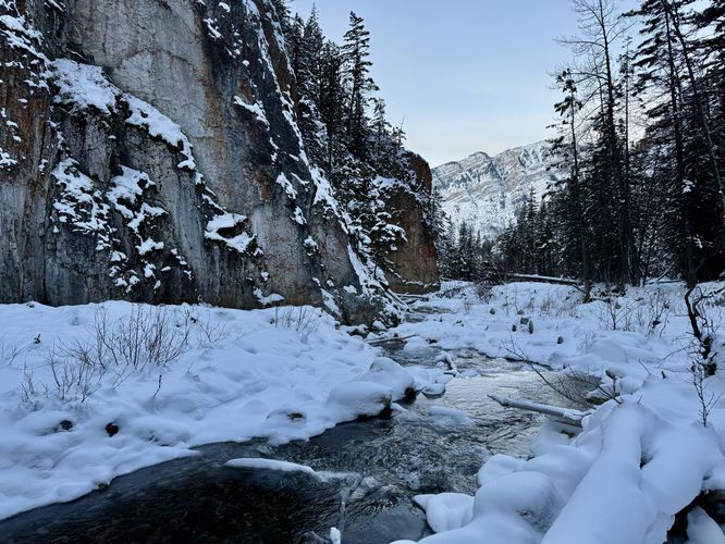
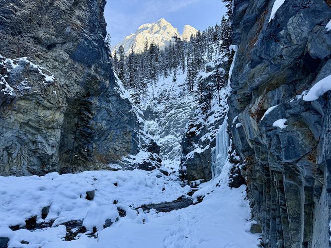
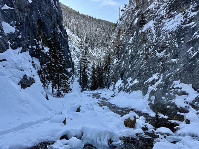
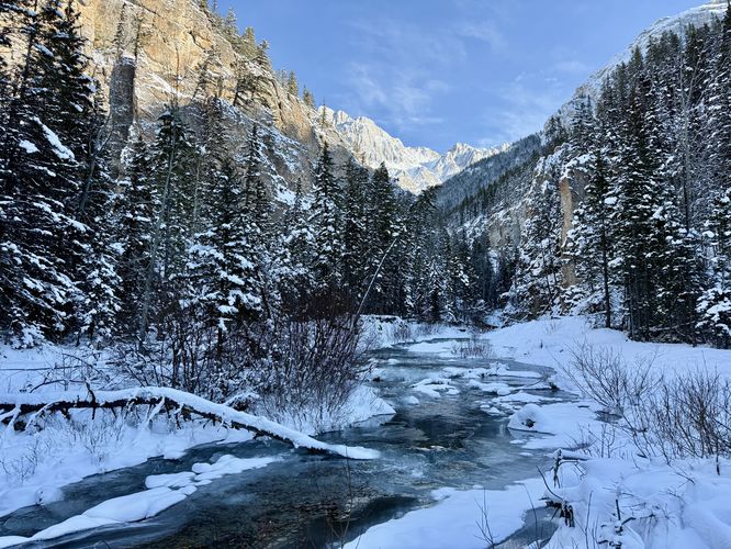
Located south of Kananaskis Village in Kananaskis Valley sits King Creek Canyon with surrounding alpine mountains that tower overhead. In the middle of King Creek Canyon sits a hiking trail that leads up the creek to reach several ice climbs that form each year during the winter.
This trail guide leads hikers and ice climbers alike up King Creek Canyon to reach four different flows (seasonal cascades) that form spectacular WI2/WI3 ice climbs. The hike is considered easy and approximately 3 km out-and-back.
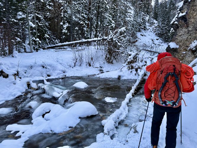
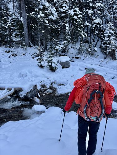
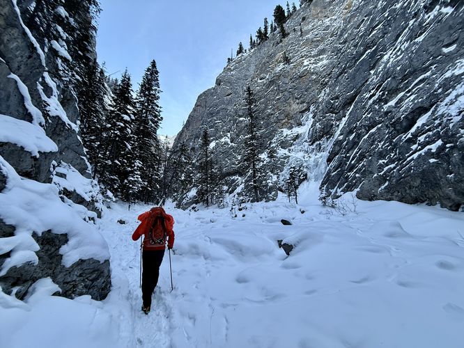
Once you're on the King Creek Canyon Trail, the hike upstream is fairly straightforward with a few gotchas, or should I call them creek crossings. Along the hike up King Creek, you'll be faced with a handful of creek crossings. Some of which pass through fairly deep sections in the creek, forcing hikers to backtrack slightly to find boulders or more shallow waters to cross. Hikers will likely find creek crossings, if hiking in directly from Route 40, near kilometer markers 0.44, 0.9, 0.97, 1.34, and 1.5 near the 4th flow.
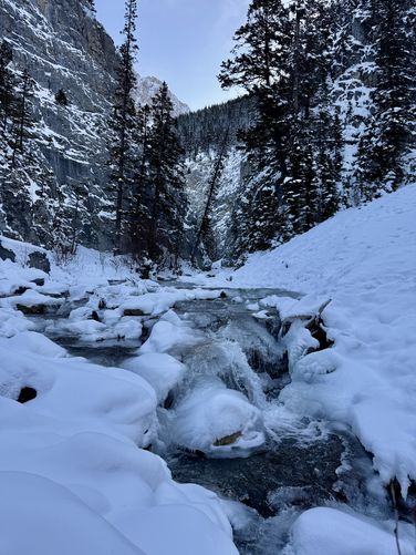
The hike up King Canyon Creek, especially during the winter or cold months, is fairly magical especially when the canyon and surrounding alpine peaks are covered in snow. Please be aware of avalanche hazards along the route as there are several avalanche chutes that lead directly into the canyon and the trail. Hikers and ice climbers can check conditions on Avalanche Canada's website.
Falling rock: The canyon include steep walls and towering alpine peaks overhead. Seldomly, the mountain sends rocks tumbling down into the canyon, so beware.
Avalanches: King Creek Canyon is prone to avalanches and includes several avalanche chutes that sit right on-trail. Be prepared and check conditions on Avalanche Canada before heading out.
This trail guide leads hikers and ice climbers alike up King Creek Canyon to reach four different flows (seasonal cascades) that form spectacular WI2/WI3 ice climbs. The hike is considered easy and approximately 3 km out-and-back.
Hiking up King Creek Canyon
This hike begins at the parking turnout for King Creek Canyon. During warm months, the canyon's trailhead can be reached from the main parking lot, located just down the road from the trailhead listed here. During the winter, the main parking lot is not maintained, but you can still hike in from Route 40 (Kananaskis Trail).Once you're on the King Creek Canyon Trail, the hike upstream is fairly straightforward with a few gotchas, or should I call them creek crossings. Along the hike up King Creek, you'll be faced with a handful of creek crossings. Some of which pass through fairly deep sections in the creek, forcing hikers to backtrack slightly to find boulders or more shallow waters to cross. Hikers will likely find creek crossings, if hiking in directly from Route 40, near kilometer markers 0.44, 0.9, 0.97, 1.34, and 1.5 near the 4th flow.
The hike up King Canyon Creek, especially during the winter or cold months, is fairly magical especially when the canyon and surrounding alpine peaks are covered in snow. Please be aware of avalanche hazards along the route as there are several avalanche chutes that lead directly into the canyon and the trail. Hikers and ice climbers can check conditions on Avalanche Canada's website.
1st Flow Ice Climb (aka Magic Touch) - 1.23 km
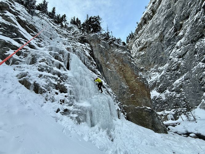
Near the 1.23 km marker sits the first flow ice climb of King Creek Canyon, aka Magic Touch located to the south. According to Will Gadd's app, Ice and Mixed Climbing: Western Canada (iOS, Android), Magic Touch is a WI3 R M3, 25m climb with a thin sheet of ice that leads to a mixed traverse. More information on Magic Touch can be found on Will's app (iOS, Android).Main Flow / 2nd Flow / The Mentor - 1.42 km
Located further up King Creek Canyon sit three more ice climbs. Cross King Creek one more time to continue following the trail as it leads north and around a large bend before the main flow (2nd flow) can be found. This ice climb doesn't appear to have any formal name, but since I got to learn from Sarah Hueniken on this trip, I refer to this one as The Mentor. The Mentor is approximately 30m (~100 feet) tall and has a difficulty rating of WI2/WI3. Earlier in the season, the base of the route is approximately WI3 with steep ice and at least two bulges that provide a bit more work to traverse. Near the middle of the climb sits an easy ramp and provides climbers with a bit of a break. The ramp, in early season ice, forms with wetter (warmer) water and thus is really easy to get your tools into. Just beyond the ramp sits the hardest sections of the climb where thin ice presents several bulges to traverse to reach the top with thinner ice along the way. I personally made it ~3 meters below the top, but the climb on The Mentor is a whole lot of fun. At the top of the climb sits a bolted anchor and climbers should bringing a 70m rope for this one. Huge thanks to Sarah Huenkien for guiding and setting the line!3rd Flow - 1.56 km
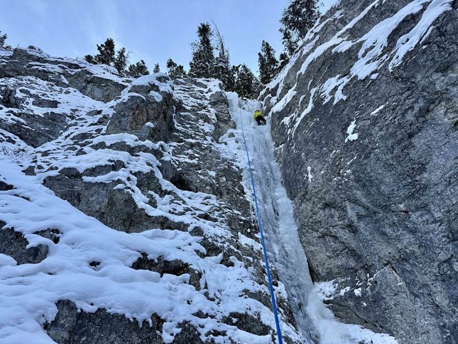
Just up the creek from The Mentor (Main Flow) sits the 3rd Flow for ice climbers. On this trip, we skipped over that climb and instead took a short stab at the 4th Flow (aka Legend's Chimney). The 3rd Flow appears to be a similar difficulty rating for ice climbers around the WI2/WI3 range.4th Flow (aka Legends Chimney) - 1.52 km
The 4th Flow and last popular ice climb in King Creek Canyon can be found around 1.52 km from Route 40, the Legends Chimney. The Legends Chimney is a WI3 climb with no bolted anchor at the top so for most climbers, you'll likely be setting an anchor on a tree located near the top of the flow. Legends Chimney is approximately 20m (66 feet) tall with an ice ramp that leads to a vertical chimney, especially during the earlier season when less ice has built-up. Near the top of the climb, it leads to a couple of bulges that provide additional challenges to climbers. This 4th Flow of King Creek Canyon does not have an official name, so I named it Legends Chimney because on my guided day by Sarah Huenkien, we ran into Barry Blanchard who had a guest of his climbing the route. I felt like two legendary climbers and one hell of a fun ice route deserved a noteworthy name, hence Legends Chimney. On that day I got to climb Barry's line with Sarah belaying - a super cool experience for a total noob.Hike to Parking - 1.52 to 3 km
After exploring the trail, whether you're ice climbing or simply hiking out to view ice climbers or to explore the canyon, the hike back to parking is easy. Hiking back down King Creek Canyon is faster on the way out than on the way in, especially since you've already solved the creek crossing problems. Return back at the parking along Route 40 for an easy 3 km out-and-back hike.Huge Thanks to Sarah Hueniken
Since I'm a noob ice climber, I hired Sarah Hueniken to guide me along this adventure. Sarah set up the route on The Mentor (Main Flow / 2nd Flow) and belayed me as I made a handful of pitches up the climb. I could have never accomplished this myself and with Sarah as a teacher, I was able to learn a whole lot while having a ton of fun that day. Thanks to Sarah's expert climbing experience, my success on these routes was really her success. If you're looking for an awesome, patient mountain guide in the Canmore area, do not hesitate to reach out to Sarah Hueniken about guiding. Last, a big Thank You is due to Barry Blanchard as well - Barry came out that same day with his guest Victor and he set up a route along the 4th Flow (Legends Chimney). Barry was kind enough to let me climb his route with Sarah on belay.. two legends of the alpine with one total noob learning from them. Thanks to them, I was able to be successful and had a ton of fun that day, hence the routes' new (unofficial) names.The Mentor & Legends Chimney Unofficial Names
Note that neither name for the 2nd Flow (Main Flow) and 4th Flow ice climbs have official names. I simply nicknamed the routes because of my own experience that day. Apologies to the community in case these routes have official names!More Ice Climbs in Alberta
Looking for more ice climbs in Alberta? Consider checking out Wedge Smear close by or for a backcountry adventure consider climbing This House of Sky in the Ghost River Wilderness!Warning
Creek crossings: This trail includes several creek crossings to reach the waterfall flows / ice climbs near the back of the canyon. Some creek crossings include deeper water where hikers will likely need to backtrack to find better spots to cross.Falling rock: The canyon include steep walls and towering alpine peaks overhead. Seldomly, the mountain sends rocks tumbling down into the canyon, so beware.
Avalanches: King Creek Canyon is prone to avalanches and includes several avalanche chutes that sit right on-trail. Be prepared and check conditions on Avalanche Canada before heading out.