This House of Sky Loop within the Ghost River Wilderness outside of Canmore, Alberta is an ice climb and hike that features approximately 312 meters (1,000 feet) of vertical ice climbing in a steep canyon that traverses about 15 cascades at WI3.
Hiking Down to Parking
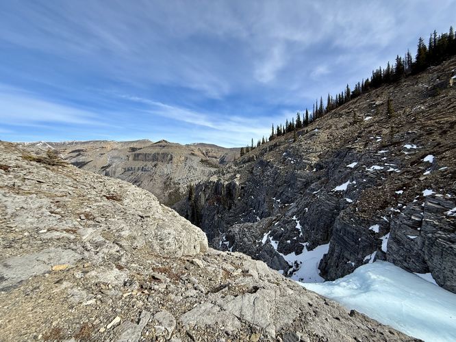
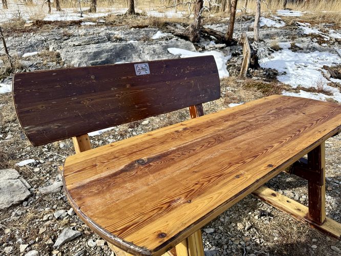
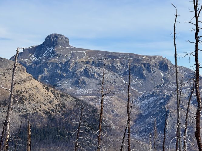
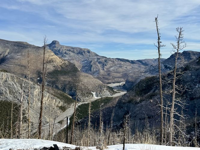
After exploring the ice route, or if you simply plan to hike the red blazed trail out-and-back, the descent from the top of This House of Sky to reach parking is not exactly trivial. First, you'll hike along a plateau of dead-standing evergreens that was previously burned by wildfire. Located around 1.25 km is a picnic table and bench dedicated in memory to Dick Howe (1937 - 2018). As you hike along the plateau to reach the northeast ridge of the mountain, you'll find stunning views to the east of Black Rock Mountain and the Ghost River as it winds through the valley below. To the west sits obstructed views (through the dead standing) of Mount Aylmer with its jagged snow-covered triangular peak.
Once you pass the fixed rope ledge, the hike down the mountain ridge is straight forward. Simply follow the red blazes as they pass through the dead standing evergreens. Watch your step as the loose soil and potential muddy spots can send you for a ride downhill. Eventually, you'll reach the trail and the dry run you hiked up to reach the slot canyon. Simply take a left-hand turn to hike down the dry run and back to the parking area to complete this stunning ice climb and hike back.
Pets
Just hiking? Dogs are allowed and should probably be leashed—you are in a vast wilderness area after all. Ice climbing? Probably want to leave the dog at home!
Steep ledges: This route passes at least two steep ledges along the red blazed trail that leads from the dry run up to the top of the ice climb.
Steep terrain: The red blazed trail leads through areas of fairly steep terrain with loose soil and small rocks. Trekking poles really help on this one.
Huge Thank You to Will
My friend Sam and I
would have never been able to accomplish ice climbing this route
without the expertise, knowledge, and patience of the legendary mixed climber and mountain guide,
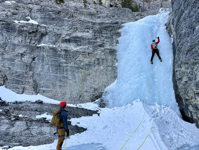
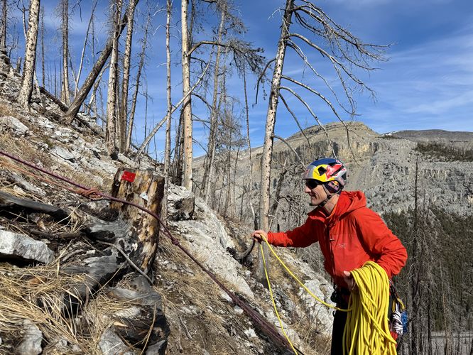
Will Gadd. I hired Will for an adventure, but to also learn from one of the world's best
mountaineers and climbers. He did not disappoint and even pushed
me to my mental limits when climbing this route while cheering me on the entire way. As a novice ice
climber, this route blew me away and made me rethink about what's
possible for myself and my limits out in the mountains with the right people, gear, and know-how. I cannot thank
Will enough for putting together such an amazing trip for us, including our adventures and learning the ropes at the Wedge
Smear Ice Climb just one day earlier.
Ice Climbing Difficulty Rating
According to Will Gadd's app, Ice and Mixed Climbing: Western Canada (iOS, Android), this is Class 1 ice with a WI3 difficulty rating.Hiking Difficulty
Due to the rock ledges, steep slopes, and loose soil and rocks, the hike down or even up along the red blazed trail should be considered hard for the average hiker. Note that the trail is not really a hiking trail, but rather a descent trail for the climb. Canyoneers, during warm months, will use this route as well, but there are far better hiking trails in the area for the effort. Last, the red blazes (reflectors) are meant to help in the descent, but there are some white arrows as well. The red reflectors are mostly used, if not entirely, for the descent.Ice Climbing the Canyon
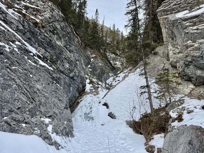
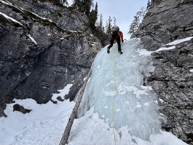
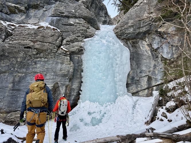
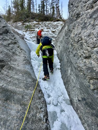
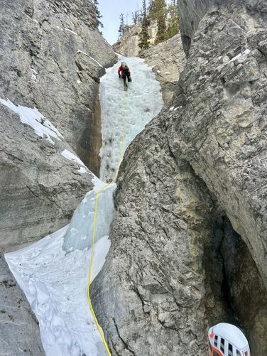
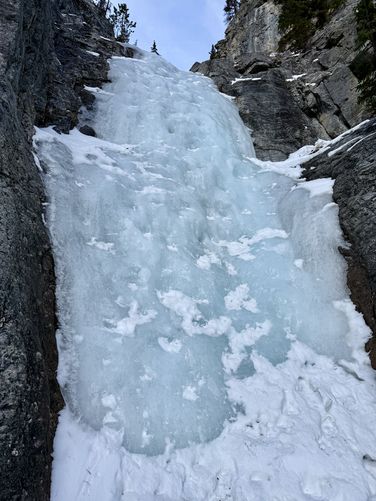
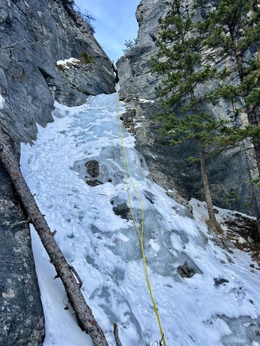
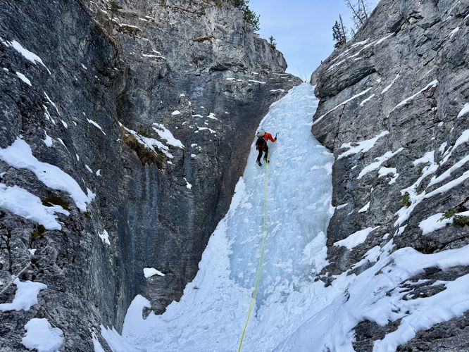
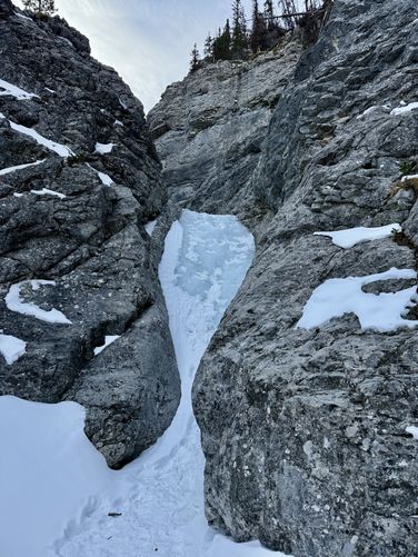
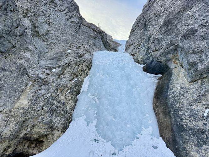
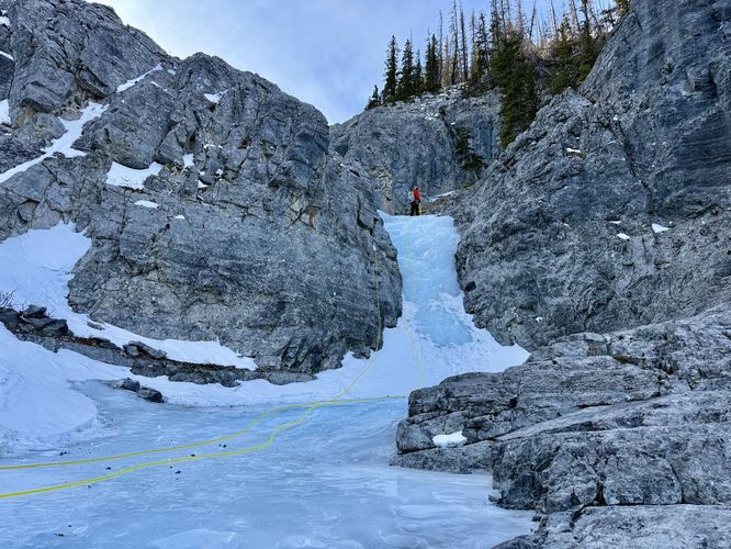
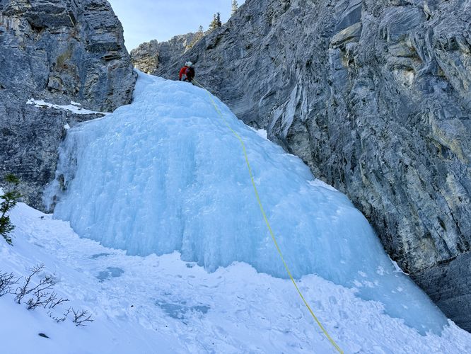
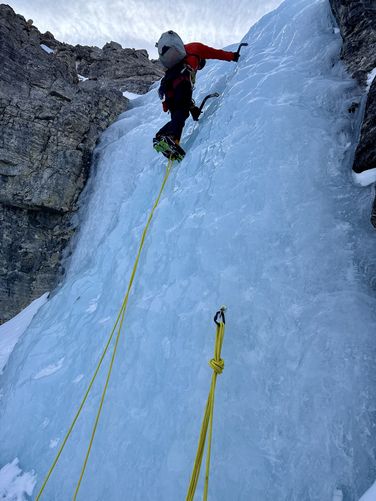
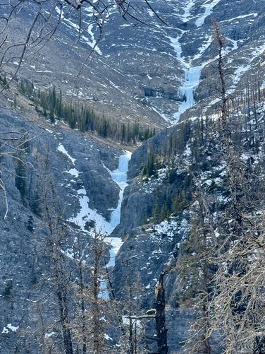
To reach the start of the ice, you'll first need to hike up a dry run for approximately 260 meters. You'll find the start of the slot canyon on your right-hand side where short ice ramps quickly lead to vertical ice climbs. On your way up the canyon, you'll find that the top of each pitch includes bolted belay stations. On our trip here, I hired Will Gadd to lead us novice ice climbers on a backcountry adventure which brought us to the ice route: This House of Sky—and it turned out to be a great choice on his part. The slot canyon includes several short climbs (7+ meters) tall and about 10 larger climbs. In the route provided, I've mapped and included almost all of the waterfalls (steps) that the climb has to offer, but I know I missed a handful of shorter ice ramps. One gotcha is the main crux of the climb—a downed tree that sits at the top of a very-large ice wall located around 0.8 km from the trailhead. The downed tree makes for a bit of scrambling and dry tooling with your crampons to get up and around the top of an ice ramp. As you ascend further, it feels like the frozen waterfalls get taller and steeper. The thick blue ice is a stunning reminder that this truly is world class ice climbing. One of the last climbs closer to the top is a fan waterfall that freezes into a behemoth-sized block of ice with some ~45-degree angle slopes along its upper ramp. This waterfall is a bit more challenging because it tends to flake off a lot easier than the steeper waterfalls below it. After the fan waterfall, just one more steep and tall waterfall is left to climb which leads to the very top of the route. Finally, around 1.2 km from the trailhead, you'll reach the very top of This House of Sky where the main ice route ends. Further upstream, however, is a WI4+ climb that presents itself to more experienced ice climbers. For Will, the upper ice climb is just another walk in the park for his soloing adventures. Here, we took a nice long break, had lunch and a red bull (as is per tradition with Will), enjoyed the alpine views and the majesty of the upper ice climb (that we skipped), and then started our descent down the red blazed hiking trail.Hiking Down to Parking
After exploring the ice route, or if you simply plan to hike the red blazed trail out-and-back, the descent from the top of This House of Sky to reach parking is not exactly trivial. First, you'll hike along a plateau of dead-standing evergreens that was previously burned by wildfire. Located around 1.25 km is a picnic table and bench dedicated in memory to Dick Howe (1937 - 2018). As you hike along the plateau to reach the northeast ridge of the mountain, you'll find stunning views to the east of Black Rock Mountain and the Ghost River as it winds through the valley below. To the west sits obstructed views (through the dead standing) of Mount Aylmer with its jagged snow-covered triangular peak. Rock Ledge - 1.68 km
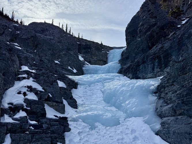
Once you begin to leave the plateau the trail becomes a lot steeper as it follows red blazes down loose soil peppered with small rocks. The first really steep downhill sits around 1.68 km in the route provided where you'll find a fairly easy rock ledge with several small steps that leads down about 2.5 meters. While it's not very difficult, with snow covering the rocks and slick boots, you might want to consider wearing ice spikes here. There are ledges between you and the final stretch along the mountain's ridge, so be prepared to take it slow and bring trekking poles for your own safety.This House of Sky Canyon View - 1.95 km
Around 1.95 km from the trailhead, you'll reach a stunning view of the upper portion of the slot canyon that you just ice climbed. This is a great spot to take a photo of your accomplishment.Fixed Rope Ledge - 2.08 km
The crux of the downhill is a rock ledge located around 2.08 km. This rock ledge is approximately 5 meters tall with varying rock steps in between. The cliff is quite vertical which makes for a difficult descent. During our downhill hike here in early March 2025, there was a fixed rope set up, but you can't always trust someone else's fixed rope depending on when it was installed and how warn its become. Luckily, Will helped us here by lowering us as we used both his rope and the existing fixed rope for safety measures. Below the cliff is another fixed rope that helps guide you down a very steep section of loose soil to reach a less-sketchy slope along the mountain's ridge.Once you pass the fixed rope ledge, the hike down the mountain ridge is straight forward. Simply follow the red blazes as they pass through the dead standing evergreens. Watch your step as the loose soil and potential muddy spots can send you for a ride downhill. Eventually, you'll reach the trail and the dry run you hiked up to reach the slot canyon. Simply take a left-hand turn to hike down the dry run and back to the parking area to complete this stunning ice climb and hike back.
Parking and How to Reach the Trailhead
Driving into the Ghost River Wilderness along the Ghost River is no joke. I don't write that to try and scare people, it literally is an off road adventure that only experienced backcountry travelers with 4wheel drive vehicles should even consider attempting. Google Maps and other apps will likely not get you to the trailhead... First off, to reach the proper roads that lead into the ghost is not straight forward and following google map directions may only get you lost in the vast wilderness of the Canadian Rockies... but simply crossing the ghost river, assuming an ice bridge is available, is another challenge that should be left to the experienced and/or local guides. This off road adventure will reduce the longevity of your vehicle and may even get you stranded if you're not careful. A tow out of the ghost starts around $1,000 CAD before hourly rates are tacked on. It may take a tow truck several hours to drive out to get your vehicle and several hours to get your vehicle back to a shop for repairs, which might add another $1,000 CAD. With all of this said, do not attempt to reach this trailhead without experience, the right vehicle, or a local guide with both! If you do plan to head out to this trailhead, the turn-by-turn directions can be found in Will Gadd's mobile app Ice and Mixed Climbing: Western Canada (iOS, Android). The app is not free, but it's an invaluable resource if you plan backcountry climbing adventures in this part of Canada.Pets
Just hiking? Dogs are allowed and should probably be leashed—you are in a vast wilderness area after all. Ice climbing? Probably want to leave the dog at home! Warnings
Ice climbing: If you plan to traverse this ice route, you must do so at your own risk while assessing your own skill and comfortability levels. Unsure of your skill levels? It might be best to hire a guide for this climb like we did.Steep ledges: This route passes at least two steep ledges along the red blazed trail that leads from the dry run up to the top of the ice climb.
Steep terrain: The red blazed trail leads through areas of fairly steep terrain with loose soil and small rocks. Trekking poles really help on this one.