Loading...

🎉 Enjoy a Free 7-Day Supporter Trial and Unlock Exclusive Perks — No Credit Card Required. Learn more.

Wedge Smear Ice Climb

Directions
Map
Pictures
Send to App
Distance:
3.5 km / 2.2 Miles
Type:
Out-and-Back
Difficulty:
Moderate
Time to Hike:
1 hour, ~6 minutes
Features:
Surface Type:
Dirt
Park:
Spray Valley Provincial Park
Town:
Kananaskis Village, Alberta - Canada
Directions:
50.861125, -115.175753
Added:
March 01, 2025
Updated:
March 04, 2025
Copy Trail Link Hiking this trail? Send a friend or family member a link to this trail guide for your own safety. Hike at your own risk (disclaimer)
Loading...
Loading...
215m

Total Change
230m

Ascent
229m

Descent

Download the Trail Route for Offline Use

Supporters get exclusive access to download trail routes to the MyHikes app for offline use. Stay prepared on your adventure, even without an internet connection! Become a Supporter today to unlock this feature and hike with confidence.

Send to App

Wedge Smear Ice Climb

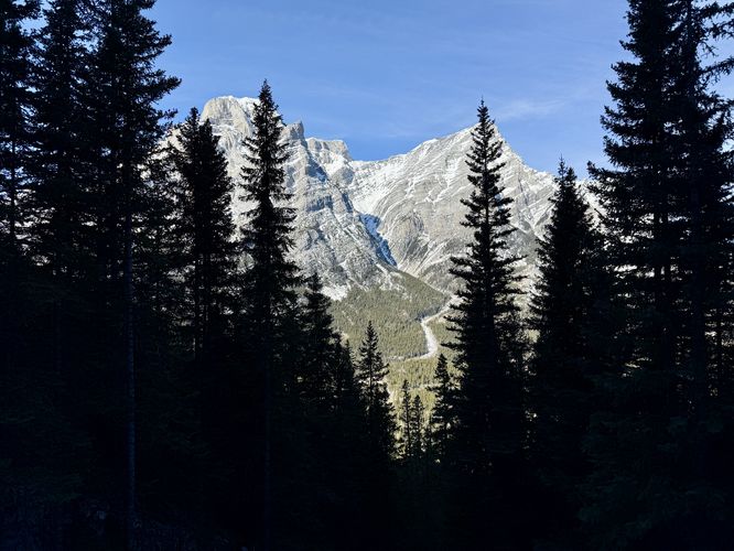
The Wedge Smear Ice Climb near Kananaskis Village, Alberta within Spray Valley Provincial Park sits along the northwestern slopes of The Wedge, in a mountain hollow below Limestone Mountain's peak where a seasonal mountain seep freezes into a fun and engaging ice climb during the winter.

Ice Climb Difficulty Rating

According to Will Gadd's app, Ice and Mixed Climbing: Western Canada (iOS, Android), this is Class 1 ice with a WI2 - 4 difficulty rating, depending on where you climb. The height of the entire ice wall is approximately 30 meters.

Hiking to Wedge Smear

The hike to reach Wedge Smear is fairly straight forward. Starting at the Galatea Creek parking area, you'll head north along Alberta Highway 40 for approximately 580 meters to reach the Wedge Smear Trail, located on the east side of the road. Hike down the trail for about 230 meters and take a right-hand turn to continue following the Wedge Smear Trail. The hike uphill mostly begins here as it gradually ascends for about 600 meters before the elevation grade picks up. During the winter, assuming you're hiking up to ice climb, you might want to consider attaching your crampons around this area since the trail turns into a full-on ice run. The hike up the ice is straight forward with several easy switchbacks built directly into the frozen run. Many people will attempt to bypass some of this ice for safety, but traversing up the frozen run can be fun too. You'll reach the bottom of Wedge Smear around 1.72 km from the parking lot—this is where the real fun begins. The ice climb of Wedge Smear is a whole lot of fun, especially if you're with someone who knows what they're doing. For this trip, I hired Will Gadd to show me the ropes—literally—and to help me learn and improve from my previous solo ice adventures. Will chose Wedge Smear for our first day and it turned out to be a great spot to teach me and my friend how to tie in, communicate, belay, and climb vertical ice. We spent several hours at Wedge Smear climbing and having a whole lot of fun. Oh and if you're tired of climbing this frozen mountain seep, you can always turn around to find beautiful views of Mt. Kidd located across the valley. When done exploring or climbing the ice, the hike back is straight forward, but make sure to be extra mindful of the ice run that slopes down into the trees.

Parking

There's a very large parking lot located on the west side of Highway 40 at the parking coordinates provided at the Galatea Creek access lot. The lot can fit approximately 50 vehicles as of March 2025. It's best to not leave anything valuable in your vehicle just in case.

Pets

Dogs are allowed, should be leashed, and picked up after.

Warning

Ice is slippery: This route traverses through a fairly steep ice run that leads up to the base of the main ice climb of Wedge Smear. Even traversing the lower frozen run to reach the base of the climb can be a real hazard, especially if you slip on your crampon, roll and ankle, trip, or fall. If planning to traverse any ice, you must bring and wear the proper gear (crampons, et al.) for your own safety. Additionally, standing at the base of the climb features a fairly skinny section of ice to walk around for belaying so watch your step at all times and take extra caution.

Cougars and grizzly bears: This area is home to the cougar (mountain lion) and grizzly bears. While encounters are rare, it's best to travel in groups and not solo hike if you can avoid it. You can learn more about hiking in cougar habitats or hiking in grizzly bear habitats on the Alberta Park's official site.
  1. Parking

    50.861125, -115.175753
  2. Main Trailhead

    50.861125, -115.175753
  3. View of Mt. Kidd

    50.860528, -115.165139
    View of Mt. Kidd
  4. Ice climbers on Wedge Smear (WI2 - 4)

    50.860497, -115.165161
    Ice climbers on Wedge Smear (WI2 - 4)
No community routes found. To add your own hike as a Community Route for this Trail guide, leave a Trip Report with an attached GPX file.

Seasons

All

Trip Reports

Trail Guide By:
Admin user profile picture
2.2 miles / 3.5 km

Weather Forecast

In Kananaskis Village, AB

Explore Hiking Trails

You May Also Like

Colorado's Million Dollar Highway - Plan a day's drive adventure along the iconic Million Dollar Highway in Colorado. Explore the best short trails, roadside stops, waterfalls, vistas, ghost towns, and hot springs within a ~6 hour road trip.
Explore

Colorado's Million Dollar Highway

Plan a day's drive adventure along the iconic Million Dollar Highway in Colorado. Explore the best short trails, roadside stops, waterfalls, vistas, ghost towns, and hot springs within a ~6 hour road trip.

Read
Glacier's Going-to-the-Sun Road - Discover the breathtaking beauty of Glacier National Park along the iconic Going-to-the-Sun Road. From stunning roadside stops to picturesque waterfalls and vistas, this engineering marvel offers endless opportunities for exploration.
Explore

Glacier's Going-to-the-Sun Road

Discover the breathtaking beauty of Glacier National Park along the iconic Going-to-the-Sun Road. From stunning roadside stops to picturesque waterfalls and vistas, this engineering marvel offers endless opportunities for exploration.

Read
New York's Best Waterfalls - Whether you're planning a day hike, roadside stop, or a leisurely short walk, this guide provides hikers, travelers, and locals alike with 63 different locations to over 100 scenic waterfalls to help plan your next adventure!
Explore

New York's Best Waterfalls

Whether you're planning a day hike, roadside stop, or a leisurely short walk, this guide provides hikers, travelers, and locals alike with 63 different locations to over 100 scenic waterfalls to help plan your next adventure!

Read

Before you boogie...

Find our trail guides useful? Consider becoming a Supporter to unlock perks!

MyHikes is an indie platform that makes exploring public trails easier for everyone. The platform has no investors, no ads, and is owned and operated by one person, Dave Miller. Dave has personally mapped and written over 1,800 trail guides on MyHikes for the public to explore. MyHikes has helped millions outdoor enthusiasts plan their next adventure.

But it takes a lot of time 🕦, money 💰, work, and espresso shots ☕ to run MyHikes, including hiking , mapping , writing , and publishing new trails with high-quality (accurate) information... along with software engineering (coding) the platform like building new features, website and mobile app development (iOS and Android), site maintainance . and much much more.

Supporters unlock website and mobile app perks with an annual one-time payment of $25 (you renew) 😎👍. Or you can simply make a Donation of your choice. Otherwise, you can support us by telling your friends about MyHikes - both quick and free 🎉

Admin user profile picture

Dave Miller
MyHikes Founder