Loading...

🎉 Enjoy a Free 7-Day Supporter Trial and Unlock Exclusive Perks — No Credit Card Required. Learn more.

Kepler Overlook Hike

Directions
Map
Pictures
Send to App
Distance:
5.9 Miles / 9.5 km
Type:
Out-and-Back
Difficulty:
Moderate
Time to Hike:
2 hours, ~57 minutes
Features:
Surface Type:
Dirt
Park:
George Washington National Forest
Town:
Strasburg, Virginia
Directions:
38.971371, -78.563161
Added:
January 27, 2025
Updated:
April 04, 2025
Copy Trail Link Hiking this trail? Send a friend or family member a link to this trail guide for your own safety. Hike at your own risk (disclaimer)
Loading...
Loading...
1,086'

Total Change
1,155'

Ascent
1,155'

Descent

Download the Trail Route for Offline Use

Supporters get exclusive access to download trail routes to the MyHikes app for offline use. Stay prepared on your adventure, even without an internet connection! Become a Supporter today to unlock this feature and hike with confidence.

Send to App

Kepler Overlook Hike

This secluded hiking area near Van Buren Furnace has several nice campsites, a vista west from Tea Mountain, the panoramic Kepler Overlook on Little North Mountain, and picturesque Cedar Creek. It's also the perfect car camping spot, with several large camp sites on the banks of Cedar Creek. If you car camp, also consider following the Tuscarora Trail up Little Sluice Mountain and enjoy the vistas at White Rocks.

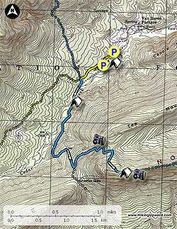
In the late Fall, Winter, and early Spring the lower gate on Van Buren Road will be closed. At these times park on the right next to a large campsite. Note: Backcountry camping in the National Forest is on a first-come first- serve basis. You can't reserve campsites, but there is no cost to camp. If it's open, feel free to camp there!

  • Mile 0.0 - From the lower closed gate follow the yellow blazed forestry road for 0.2 miles to the second parking area and seasonal closed gate. That parking area, and second large car-camp site, is on a left turn out.

  • Mile 0.2 - Continue straight passing the seasonal closed gate and continuing on the yellow blazed forestry road. In 0.3 miles reach the intersection of the blue blazed Tuscarora Trail.

  • Mile 0.5 - Turn left down towards Cedar Creek following the Tuscarora Trail as is passes another closed gate and then reaches the crossing of Cedar Creek.

  • Mile 0.7 - Cross Cedar Creek and pass a large camping area. Continue to follow the blue blazed Tuscarora Trail for 0.1 miles where the blue blazed trail turns left off the path it's been follow and starts climbing Tea Mountain. Watch for the double blazed tree that marks this turn off.

  • Mile 0.8 - After starting the climb up Tea Mountain the Tuscarora Trail becomes more narrow and moss covered for 0.3 miles recrossing the creek where a former wooden bridge crossed, then widens back into an old forestry road. The trail passes a hollow on the right, then makes a hairpin turn left and leaves the forestry road. There is a sign here indicating a spring. Again make sure to look for a double blazed tree that marks this turn.

  • Mile 2.1 - Turn left off the forestry road as the Tuscarora Trail continues to climb Tea Mountain. Pass a spring that was put in by PATC volunteers in 2018 then make several switchbacks before reaching an unmarked side trail at another switchback. Follow the side trail 150 feet around the back of a rock outcrop for a panoramic view west towards Little Sluice Mountain. Return to the Tuscarora Trail to continue the hike.

  • Mile 2.7 - Continue up the Tuscarora Trail making one more switchback and reach the saddle between Tea Mountain and Little North Mountain. The trail will then make the short climb to the Little North Mountain ridge. There is a large camping area on the left.

  • Mile 3.2 - Follow the Tuscarora Trail along the ridge for 0.1 miles to the panoramic Kepler Overlook, and a great ridgeline camping site.

  • Mile 3.3 - From the overlook and campsite retrace your route back to the parking area

  • Mile 5.9 - Arrive back at the parking area.

Explore 78 trails near Strasburg, VA
  1. Parking

    38.971371, -78.563161
  2. Main Trailhead

    38.971371, -78.563161
No community routes found. To add your own hike as a Community Route for this Trail guide, leave a Trip Report with an attached GPX file.

Hazards

Ticks - Lyme Disease More Info (CDC)
Snakes

Seasons

All

Blaze Color

Blue

Trip Reports

Trail Guide By:
HikingUpward user profile picture
5.9 miles / 9.5 km

Weather Forecast

In Strasburg, VA

Explore Hiking Trails

You May Also Like

New York's Best Waterfalls - Whether you're planning a day hike, roadside stop, or a leisurely short walk, this guide provides hikers, travelers, and locals alike with 63 different locations to over 100 scenic waterfalls to help plan your next adventure!
Explore

New York's Best Waterfalls

Whether you're planning a day hike, roadside stop, or a leisurely short walk, this guide provides hikers, travelers, and locals alike with 63 different locations to over 100 scenic waterfalls to help plan your next adventure!

Read
25 Best Day Hikes in North Carolina - Discover the top 25 best day hikes in North Carolina, from breathtaking waterfalls to mountain peaks. Explore hidden gems, scenic views, and trails suitable for all skill levels, perfect for your next outdoor adventure.
Explore

25 Best Day Hikes in North Carolina

Discover the top 25 best day hikes in North Carolina, from breathtaking waterfalls to mountain peaks. Explore hidden gems, scenic views, and trails suitable for all skill levels, perfect for your next outdoor adventure.

Read

Before you boogie...

Find our trail guides useful? Consider becoming a Supporter to unlock perks!

MyHikes is an indie platform that makes exploring public trails easier for everyone. The platform has no investors, no ads, and is owned and operated by one person, Dave Miller. Dave has personally mapped and written over 1,800 trail guides on MyHikes for the public to explore. MyHikes has helped millions outdoor enthusiasts plan their next adventure.

But it takes a lot of time 🕦, money 💰, work, and espresso shots ☕ to run MyHikes, including hiking , mapping , writing , and publishing new trails with high-quality (accurate) information... along with software engineering (coding) the platform like building new features, website and mobile app development (iOS and Android), site maintainance . and much much more.

Supporters unlock website and mobile app perks with an annual one-time payment of $25 (you renew) 😎👍. Or you can simply make a Donation of your choice. Otherwise, you can support us by telling your friends about MyHikes - both quick and free 🎉

Admin user profile picture

Dave Miller
MyHikes Founder