Loading...

🎉 Enjoy a Free 7-Day Supporter Trial and Unlock Exclusive Perks — No Credit Card Required. Learn more.

Kelpius Cave Loop

Directions
Map
Pictures
Send to App
Distance:
0.9 Miles / 1.4 km
Type:
Loop
Difficulty:
Easy
Time to Hike:
~27 minutes
Features:
Surface Type:
Dirt
Park:
Wissahickon Valley Park
Town:
Philadelphia, Pennsylvania
Directions:
40.024892, -75.200141
Added:
November 19, 2017
Updated:
May 08, 2025
Copy Trail Link Hiking this trail? Send a friend or family member a link to this trail guide for your own safety. Hike at your own risk (disclaimer)
Loading...
Loading...
194'

Total Change
156'

Ascent
166'

Descent

Download the Trail Route for Offline Use

Supporters get exclusive access to download trail routes to the MyHikes app for offline use. Stay prepared on your adventure, even without an internet connection! Become a Supporter today to unlock this feature and hike with confidence.

Send to App

Kelpius Cave Loop

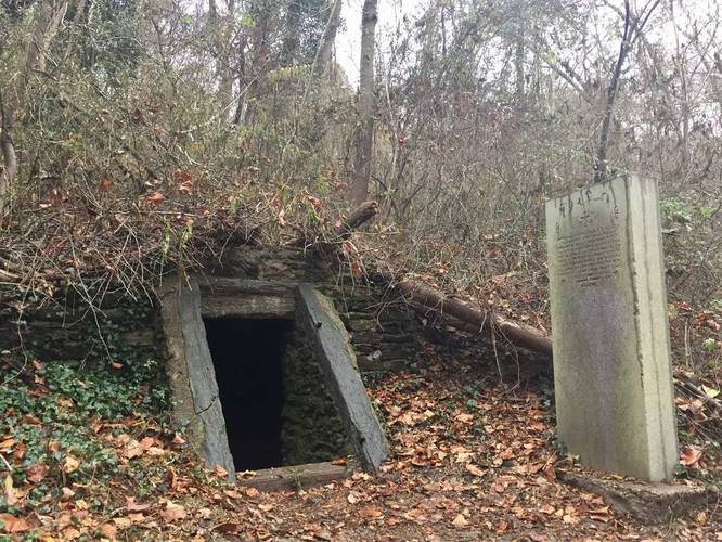
The Kelpius Cave Loop Hike at Wissahickon Valley Park in Philadelphia, Pennsylvania is a 0.9-mile hike that leads from Hermits Lane over to a small hillside cave known as Kelpius Cave (aka Hermit's Cave).

The hike itself starts at the trailhead road gate and leads down to the Yellow Trail. Once you're on the Yellow Trail, be on the lookout for a sign post labeled "Hermit's Cave 0.1 miles" to your right. Take this right until you reach the Kelpius Cave (Hermit's Cave).

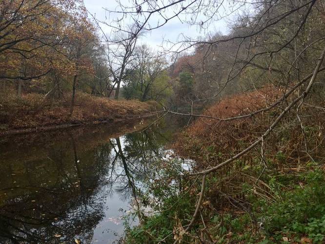
Upon leaving the cave, stay left and take the trail down to Wissahickon Creek and the Lincoln Drive Trail. Follow the Lincoln Drive trail north until you find a small stone bridge that leads across the creek and onto Lincoln Drive. Take the trail opposite of the stone bridge back up to parking - this is yet again the Yellow Trail.

Yellow blazes: most of this trail follows yellow blazes on the sign posts.

History of Kelpius Cave

In 1964 a small group of men left Germany in search of religious freedom. Known as Pietists, they pursued interests in prayer, medicinal herbs, astrology, mathematics, alchemy, philosophy, and music. Johannes Kelpius, described as a mystic philosopher, led the Pietists. They settled in this area and became known as the "Hermits of the Wissahickon." On the property in which Hermit's Cave lies, they reportedly worshiped in a Tabernacle, built log cabins and meditated in the nearby cave. The group dissolved when Kelpius died in 1708 and members joined other religious organizations such as the Mennonites, Dunkers and Seventh-Day Baptists. The Richter or Righter family acquired the property in parcels amounting to 151 aces. They operated a ferry and a shad fishery on the banks of the Schuylkill River. Local place names such as Righter Street, Righters Ferry Road, and Righters Mill Road mark lands once held by Peter Righter and his descendants. The property was eventually acquired by the city in 1895 for one dollar from the property owner at the time.
Explore 6 trails near Philadelphia, PA
  1. Parking

    40.024892, -75.200141
  2. Main Trailhead

    40.024802, -75.199942
  3. Hermit's Cave

    40.023993, -75.20138
    Hermit's Cave
  4. View of Wissahickon Creek

    40.023077, -75.197829
    View of Wissahickon Creek
No community routes found. To add your own hike as a Community Route for this Trail guide, leave a Trip Report with an attached GPX file.

Hazards

Ticks - Lyme Disease More Info (CDC)
Poison Ivy/Oak

Seasons

All

Blaze Color

Yellow

Photo Albums

Trip Reports

Trail Guide By:
Admin user profile picture
0.9 miles / 1.4 km
0.9 miles / 1.4 km
November 18, 2017
Hiking

Weather Forecast

In Philadelphia, PA

Explore Hiking Trails

You May Also Like

Colorado's Million Dollar Highway - Plan a day's drive adventure along the iconic Million Dollar Highway in Colorado. Explore the best short trails, roadside stops, waterfalls, vistas, ghost towns, and hot springs within a ~6 hour road trip.
Explore

Colorado's Million Dollar Highway

Plan a day's drive adventure along the iconic Million Dollar Highway in Colorado. Explore the best short trails, roadside stops, waterfalls, vistas, ghost towns, and hot springs within a ~6 hour road trip.

Read
New York's Best Waterfalls - Whether you're planning a day hike, roadside stop, or a leisurely short walk, this guide provides hikers, travelers, and locals alike with 63 different locations to over 100 scenic waterfalls to help plan your next adventure!
Explore

New York's Best Waterfalls

Whether you're planning a day hike, roadside stop, or a leisurely short walk, this guide provides hikers, travelers, and locals alike with 63 different locations to over 100 scenic waterfalls to help plan your next adventure!

Read

Before you boogie...

Find our trail guides useful? Consider becoming a Supporter to unlock perks!

MyHikes is an indie platform that makes exploring public trails easier for everyone. The platform has no investors, no ads, and is owned and operated by one person, Dave Miller. Dave has personally mapped and written over 1,800 trail guides on MyHikes for the public to explore. MyHikes has helped millions outdoor enthusiasts plan their next adventure.

But it takes a lot of time 🕦, money 💰, work, and espresso shots ☕ to run MyHikes, including hiking , mapping , writing , and publishing new trails with high-quality (accurate) information... along with software engineering (coding) the platform like building new features, website and mobile app development (iOS and Android), site maintainance . and much much more.

Supporters unlock website and mobile app perks with an annual one-time payment of $25 (you renew) 😎👍. Or you can simply make a Donation of your choice. Otherwise, you can support us by telling your friends about MyHikes - both quick and free 🎉

Admin user profile picture

Dave Miller
MyHikes Founder