Kellogg Mountain Overlook at State Game Lands 36 near Monroe, Pennsylvania is an easy 3-mile out-and-back hike that features an abandoned fire tower house, mountain summit, and stunning views from mountain side cliffs.
Getting to SGL 36 (Seasonal Road)
Note that the road that leads up to Kellogg Mountain, within State Game Lands 36 (SGL 36) is closed outside of the hunting season. Hunting season, and thus gate openings and closures, change each year; however, during the 2023 - 2024 hunting season, the road's gates were opened mid-September and close January 21. The road will be re-opened in 2024 from April 25, 2024 to June 2, 2024. You can check the status of seasonal SGL roads here.
Hike Description
This hike begins at the main parking lot for SGL 36, located at the coordinates provided. Before you start the hike to the cliffs and overlook, hikers will want to poke around the area near parking to see additional points-of-interest like an abandoned fire tower house, the old fire tower site, Kellogg Mountain summit, and an abandoned mine shaft.
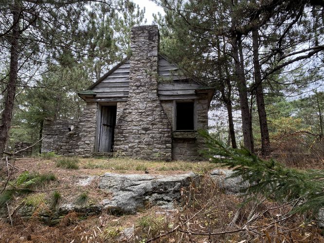
Abandoned Fire Tower House
Hikers will find the old abandoned fire tower house located adjacent to the parking lot. This abandoned structure is a unique find in Pennsylvania's woods as most of these old fire tower houses were destroyed along with the fire towers that once stood here.
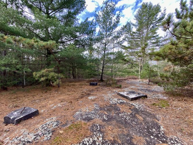
Kellogg Mountain Fire Tower Site
Just behind the abandoned fire tower house are the old concrete pillars where the fire tower once stood. Unfortunately there didn't appear to be an old survey marker, so that must have been removed when the fire tower was deconstructed. All that remains are the old footings / pillars where the fire tower was once affixed.
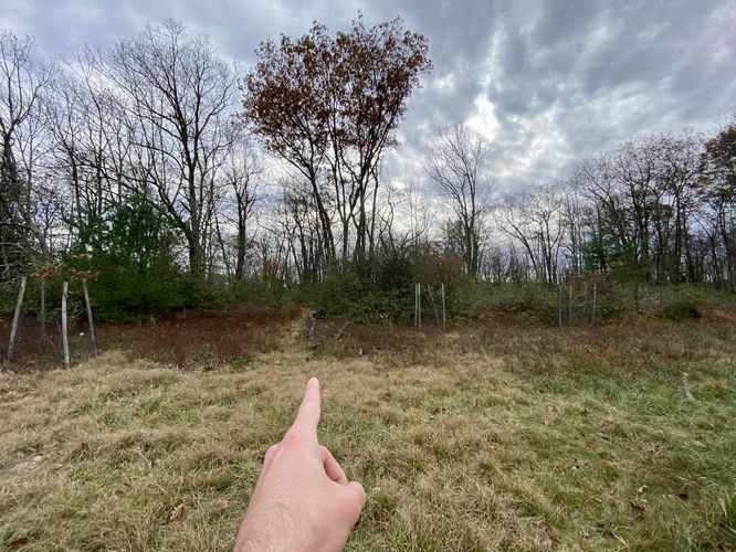
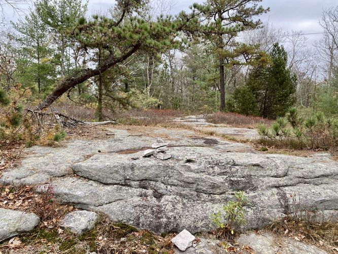
Kellogg Mountain Summit
After exploring the abandoned fire tower house, hikers can head over to the summit of Kellogg Mountain - located to the northeast of the house. The summit is noted by a ~3-foot tall rock ledge. During our hike here, some previous visitors built a small stone cairn to denote the summit.
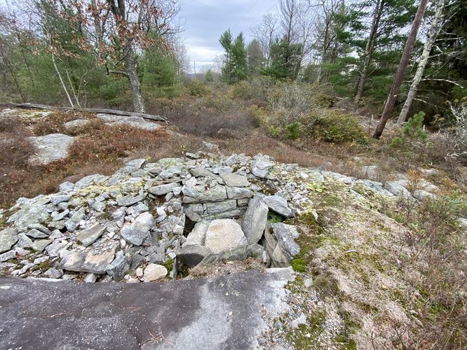
Abandoned Mine Shaft
To the East of Kellogg Mountain's summit is a square hole in the ground that's filled-in with tons of rocks. This square hole resembles an old mine shaft. While I did not search for old mine maps, one can assume this old tunnel is very-likely an abandoned mine shaft that descents deep into the Earth.
Hiking to Kellogg Mountain Overlook - Mile 0.1 to 1.45
After exploring the plethora of POI near the parking lot, hikers will begin their walk south to reach the cliffs and overlooks on Kellogg Mountain. The trail begins at the main parking lot and heads south. Along the way, there isn't too much to note except for the very-muddy and wet sections of trail near 0.9 and from miles 1.1 to 1.3. Hiker's will reach a discrete and easy-to-miss left-hand turn around mile 1.33 -- this left-hand turn follows a skinny path that leads out to the cliffs and overlooks. Hikers will head down the skinny path as it meanders its way eastward to reach the Kellogg Mountain cliffs and overlooks. The trail can be a bit difficult to follow once you get closer to the cliffs -- simply look for the easiest path through the low-growing bushes to find your way.
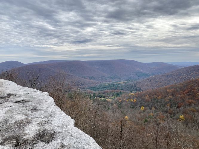
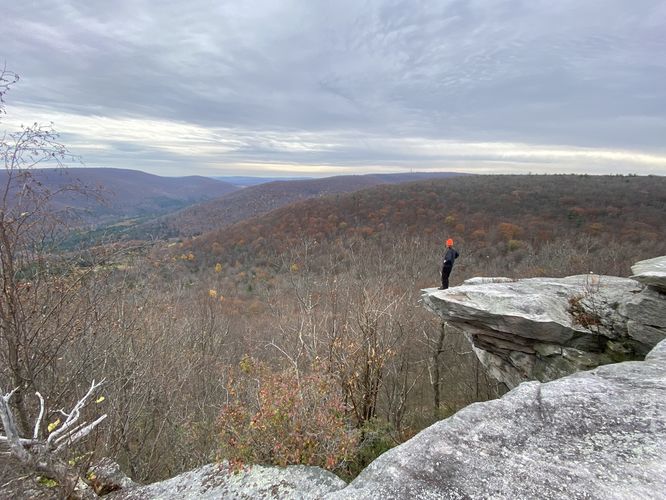
Kellogg Mountain Overlook (South) - Mile 1.45
Finally, at mile 1.45, hikers will pop out of the woods to reach the eastern cliffs of Kellogg Mountain. From the cliffs, hikers will get panoramic views facing East from the mountain. The view from the south part of the cliffs includes views of neighboring mountains above the hamlet of Kellogg, PA.
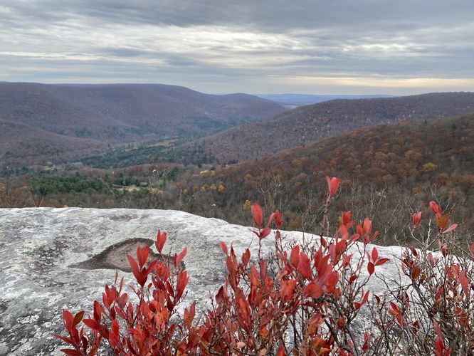
Cliff Overlook (North) - Mile 1.5
After taking in the views from the south section of Kellogg Mountain's cliffs, hikers might want to check out the northern cliff views as well. You can follow another very-skinny path that leads from the south cliffs to the north. Once at the north cliffs, there's a small 3-foot rock scramble that leads to the view. The north cliff view includes basically the same views that the south cliffs had to offer, but the north cliffs jut outward a bit. Hikers can head north to look back at the cliff line to find a neat rock overhang that juts out from the mountain side. Additionally, during Autumn, hikers will find red-hued blueberry bushes that sit in front of the view -- all combined, this part of Kellogg Mountain's overlook is by far my favorite.
After visiting both south and north cliff overlooks, the hike is half-done. The hike out follows the same path as the hike-in -- just watch the soaking-wet sections of trail on your way out.
Parking
Hikers will find parking at the coordinates provided, at the top of Kellogg Mountain -- only when the entrance road gates are opened. The road gates are opened between the months of mid-September to late January each year for hunting. Please check the Pennsylvania State Game Lands Commission for more details before heading out to ensure the road is open.
Warnings
Hunting: This hike leads through State Game Lands and due to the fact that this area is accessible during hunting season, it's smart to wear blaze orange while hiking here. During hunting season, it's against the law in Pennsylvania to hike through State Game Lands without blaze orange, so remember to bring it with you.
Steep cliffs: This hike leads to steep cliffs. Watch your step and stay back from the cliff's edge to play it safe.
Timber Rattlesnakes: This trail leads through exposed bedrock mountain terrain that's perfect for Timber Rattlesnake basking and sun bathing. While a bit more rare in this part of the state, be on the lookout for rattlers and give any you find plenty of space.
Getting to SGL 36 (Seasonal Road)
Note that the road that leads up to Kellogg Mountain, within State Game Lands 36 (SGL 36) is closed outside of the hunting season. Hunting season, and thus gate openings and closures, change each year; however, during the 2023 - 2024 hunting season, the road's gates were opened mid-September and close January 21. The road will be re-opened in 2024 from April 25, 2024 to June 2, 2024. You can check the status of seasonal SGL roads here.
Hike Description
This hike begins at the main parking lot for SGL 36, located at the coordinates provided. Before you start the hike to the cliffs and overlook, hikers will want to poke around the area near parking to see additional points-of-interest like an abandoned fire tower house, the old fire tower site, Kellogg Mountain summit, and an abandoned mine shaft.
Abandoned Fire Tower House
Hikers will find the old abandoned fire tower house located adjacent to the parking lot. This abandoned structure is a unique find in Pennsylvania's woods as most of these old fire tower houses were destroyed along with the fire towers that once stood here.
Kellogg Mountain Fire Tower Site
Just behind the abandoned fire tower house are the old concrete pillars where the fire tower once stood. Unfortunately there didn't appear to be an old survey marker, so that must have been removed when the fire tower was deconstructed. All that remains are the old footings / pillars where the fire tower was once affixed.
Kellogg Mountain Summit
After exploring the abandoned fire tower house, hikers can head over to the summit of Kellogg Mountain - located to the northeast of the house. The summit is noted by a ~3-foot tall rock ledge. During our hike here, some previous visitors built a small stone cairn to denote the summit.
Abandoned Mine Shaft
To the East of Kellogg Mountain's summit is a square hole in the ground that's filled-in with tons of rocks. This square hole resembles an old mine shaft. While I did not search for old mine maps, one can assume this old tunnel is very-likely an abandoned mine shaft that descents deep into the Earth.
Hiking to Kellogg Mountain Overlook - Mile 0.1 to 1.45
After exploring the plethora of POI near the parking lot, hikers will begin their walk south to reach the cliffs and overlooks on Kellogg Mountain. The trail begins at the main parking lot and heads south. Along the way, there isn't too much to note except for the very-muddy and wet sections of trail near 0.9 and from miles 1.1 to 1.3. Hiker's will reach a discrete and easy-to-miss left-hand turn around mile 1.33 -- this left-hand turn follows a skinny path that leads out to the cliffs and overlooks. Hikers will head down the skinny path as it meanders its way eastward to reach the Kellogg Mountain cliffs and overlooks. The trail can be a bit difficult to follow once you get closer to the cliffs -- simply look for the easiest path through the low-growing bushes to find your way.
Kellogg Mountain Overlook (South) - Mile 1.45
Finally, at mile 1.45, hikers will pop out of the woods to reach the eastern cliffs of Kellogg Mountain. From the cliffs, hikers will get panoramic views facing East from the mountain. The view from the south part of the cliffs includes views of neighboring mountains above the hamlet of Kellogg, PA.
Cliff Overlook (North) - Mile 1.5
After taking in the views from the south section of Kellogg Mountain's cliffs, hikers might want to check out the northern cliff views as well. You can follow another very-skinny path that leads from the south cliffs to the north. Once at the north cliffs, there's a small 3-foot rock scramble that leads to the view. The north cliff view includes basically the same views that the south cliffs had to offer, but the north cliffs jut outward a bit. Hikers can head north to look back at the cliff line to find a neat rock overhang that juts out from the mountain side. Additionally, during Autumn, hikers will find red-hued blueberry bushes that sit in front of the view -- all combined, this part of Kellogg Mountain's overlook is by far my favorite.
After visiting both south and north cliff overlooks, the hike is half-done. The hike out follows the same path as the hike-in -- just watch the soaking-wet sections of trail on your way out.
Parking
Hikers will find parking at the coordinates provided, at the top of Kellogg Mountain -- only when the entrance road gates are opened. The road gates are opened between the months of mid-September to late January each year for hunting. Please check the Pennsylvania State Game Lands Commission for more details before heading out to ensure the road is open.
Warnings
Hunting: This hike leads through State Game Lands and due to the fact that this area is accessible during hunting season, it's smart to wear blaze orange while hiking here. During hunting season, it's against the law in Pennsylvania to hike through State Game Lands without blaze orange, so remember to bring it with you.
Steep cliffs: This hike leads to steep cliffs. Watch your step and stay back from the cliff's edge to play it safe.
Timber Rattlesnakes: This trail leads through exposed bedrock mountain terrain that's perfect for Timber Rattlesnake basking and sun bathing. While a bit more rare in this part of the state, be on the lookout for rattlers and give any you find plenty of space.