Loading...

WINTER SALE! 50% OFF Supporter Accounts — now through January 31st. Learn More.

Keene Valley Lookout

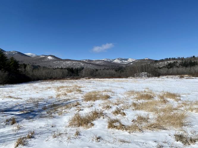
The Keene Valley Lookout at Adirondack Park in Keene, New York is a quick and easy 0.1-mile out-and-back walk to a lookout point located off of NY-73 that gives visitors a beautiful view into the High Peaks Wilderness with views of mountains like Owls Head, Blueberry Mountain, Pitchoff Mountain, and Cascade Mountain.

This is not a hike and is barely even a walk, it's just a roadside point-of-interest along NY-73 that's well-worth stopping at for a nice view of the mountains.

Parking
Visitors will find a large parking turnout by the coordinates provided. The lot is large enough for about a dozen vehicles.

Pets
Dogs are allowed if leashed and their waste must be carried out.
Explore 35 trails near Keene, NY

Know Before You Go

  • Keene Valley Lookout is an easily accessible roadside stop off NY-73 offering scenic views of the High Peaks Wilderness.
  • The lookout is a short, 0.1-mile out-and-back "walk" suitable for all ability levels.
  • A parking area accommodating about a dozen cars is available; leashed dogs are welcome with waste removal.
Interactive topographic map for Keene Valley Lookout located in Keene, NY. Click the "View Map" button to load GPS coordinates and trail markers.
Get directions
Distance
0.1 mi
Difficulty
Easy
Type
Out-and-Back
Est. Time
5 min
Elev. Gain
1'
Rating
3.0
Added
March 02, 2022
Updated
March 02, 2022

Weather Forecast

Loading...
Total Change
1'
Ascent
1'
Descent
1'
Loading...

Download the GPX Data for Offline Use

Supporters get exclusive access to download trail routes to the MyHikes app for offline use. Stay prepared on your adventure, even without an internet connection! Become a Supporter today to unlock this feature and hike with confidence.

Download Keene Valley Lookout GPX Data to the MyHikes Mobile App

Features

Vista / Lookout Point
Dogs

Points of interest

  1. Parking

    44.233363, -73.782921
  2. Main Trailhead

    44.233441, -73.782889

Safety information

For your own safety: plan ahead, let someone know where you'll be, and hike at your own risk.

Availability

All seasons

Surface type

Dirt

Trip Reports (Reviews)

Rated 3.0 out of 5 based on 1 rating.

Ready to help fellow hikers? Add a trip report to share your experience and provide valuable insights for other hikers!

0.1 miles / 0.2 km
February 28, 2022
Hiking
No community routes found. To add your own hike as a Community Route for this Trail guide, leave a Trip Report with an attached GPX file.

Popular categories

Scenic mountain view representing vista trails
Vista trails
Scenic gorge of cascades representing waterfall trails
Waterfall hikes
Rugged mountain terrain representing summit trails
Summit trails
Scenic mountain view representing dog-friendly trails
Dog-friendly
Scenic campsite with a view representing camping trails
Camping trails
Appalachian Trail logo representing A.T. hikes
A.T. hikes

You May Also Like

Colorado's Million Dollar Highway - Plan a day's drive adventure along the iconic Million Dollar Highway in Colorado. Explore the best short trails, roadside stops, waterfalls, vistas, ghost towns, and hot springs within a ~6 hour road trip.
Explore

Colorado's Million Dollar Highway

Plan a day's drive adventure along the iconic Million Dollar Highway in Colorado. Explore the best short trails, roadside stops, waterfalls, vistas, ghost towns, and hot springs within a ~6 hour road trip.

Read
Glacier's Going-to-the-Sun Road - Discover the breathtaking beauty of Glacier National Park along the iconic Going-to-the-Sun Road. From stunning roadside stops to picturesque waterfalls and vistas, this engineering marvel offers endless opportunities for exploration.
Explore

Glacier's Going-to-the-Sun Road

Discover the breathtaking beauty of Glacier National Park along the iconic Going-to-the-Sun Road. From stunning roadside stops to picturesque waterfalls and vistas, this engineering marvel offers endless opportunities for exploration.

Read
🍪 We use cookies to learn about site usage and to serve map tiles. You may block cookies manually in the browser. By continuing you agree. Learn more