Loading...

WINTER SALE! 50% OFF Supporter Accounts — now through January 31st. Learn More.

Jones Run and Doyles River Hike

This is one of the most popular waterfall hikes in the southern section of the Shenandoah National Park. There are several falls along Jones Run, plus two large falls on Doyles River. Each has several swimming holes as well. But if you plan to swim, remember that's cold mountain water, even in late summer!

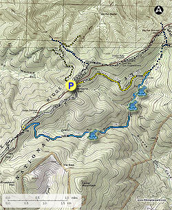
From the Browns Gap parking area cross Skyline Drive and follow the white blazed Appalachian Trail (AT) south along the ridge for 1.4 miles to the intersection of the blue blazed Jones Run Trail, and Jones Run Trail parking area.

Turn left downhill on the blue blazed Jones Run trail as it makes a switchback, then crossing the top of Jones Run before reaching the top of the first set of falls in 1.6 miles. Continue on the trail for another 0.1 miles where the trail makes another steep switchback and arrives at the base of the main falls. Continue following the trail downstream for 0.5 miles crossing Jones Run, then continuing on the left side of the run for 0.1 miles to the post marking the Doyles River Trail.

Turn left uphill on the blue blazed Doyles River Trail passing several small pools and falls before crossing a footbridge over a feeder stream. Shortly after crossing the footbridge reach the lower, and largest set of falls, then in another 0.2 miles the upper set of falls. From here the trail becomes less steep before arriving at the intersection of the Browns Gap Fire Road.

Turn left crossing Doyles River on the yellow blazed fire road for the remaining 1.7 miles back to Browns Gap.

Note: Instead of turning left on the fire road off the Doyles River Trail, you can continue on the Doyles River Trail another 0.9 miles to the AT, then turn left/south on the AT for 1.5 miles to return to Brown's Gap making it a 8.5 mile circuit. This is a good option in the summer months when the ticks can be bad in the fire roads long grasses.

Explore 62 trails near Crozet, VA

Know Before You Go

  • This 6.6-mile hike in Shenandoah National Park features multiple waterfalls and swimming holes along Jones Run and Doyles River.
  • The trail starts on the Appalachian Trail, connects to the Jones Run and Doyles River Trails, and returns via the Browns Gap Fire Road.
  • An alternative, longer 8.5-mile route exists via the Doyles River Trail and Appalachian Trail, which is recommended during tick season.
Interactive topographic map for Jones Run and Doyles River Hike located in Crozet, VA. Click the "View Map" button to load GPS coordinates and trail markers.
Get directions
Distance
6.6 mi
Difficulty
Moderate
Type
Loop
Est. Time
3.3 hrs
Elev. Gain
1,394'
Rating
4.3
Added
March 18, 2025
Updated
April 05, 2025

Weather Forecast

Loading...
Total Change
1,315'
Ascent
1,394'
Descent
1,398'
Loading...

Download the GPX Data for Offline Use

Supporters get exclusive access to download trail routes to the MyHikes app for offline use. Stay prepared on your adventure, even without an internet connection! Become a Supporter today to unlock this feature and hike with confidence.

Download Jones Run and Doyles River Hike GPX Data to the MyHikes Mobile App

Features

Dogs
Waterfalls
Water Source
Appalachian Trail logo Appalachian Trail hike

Points of interest

  1. Parking

    38.240577, -78.710857
  2. Main Trailhead

    38.24054, -78.710679

Safety information

For your own safety: plan ahead, let someone know where you'll be, and hike at your own risk.

Hazards

Snakes (Rattlesnakes, Copperheads, others)
Poison Ivy or Poison Oak

Availability

All seasons

Surface type

Dirt

Trip Reports (Reviews)

Rated 4.26 out of 5 based on 47 ratings.

Ready to help fellow hikers? Add a trip report to share your experience and provide valuable insights for other hikers!

By: Brian
6.6 miles / 10.6 km
April 30, 2017
Loved this hike! The rains from last weekend/early this week really had the falls running. We didn't regret bringing Tevas to use in crossing the creek in one place. (Nimble folks had no problems rock hopping.). Lots of small wildflowers around as well. We took the longer route, and it was fine, but the AT marker post said it was 2.2 miles back to Brown's run, not the 1.5 in the write up, and it felt like that. If you use trekking poles, this is one to remember them.
Legacy Review
By: SteveE
6.6 miles / 10.6 km
December 10, 2016
This trail has become my new favorite trail in the SNP or BRP. Without the obstruction of leaves, we had tremendous views of the multiple waterfalls. While it was super cold at the parking lot, once we got out of the wind on the trail, it was quite tolerable - we dressed well though even shedding a layer. The slight rock scrambles were a lot of fun and the climb out of the bottom was not bad at all - especially compared to most waterfall hikes around.
Legacy Review
By: Mike H
6.6 miles / 10.6 km
November 19, 2016
This was a very pleasant hike the waterfalls pale in comparison to those along the White Oak Canyon / Cedar Run circuit and aren't as grand as the Overall Run / Beecher Ridge waterfall, but they are still quite beautiful. And unlike those other hikes, the waterfalls along the Jones Run / Doyles River circuit are very accessible. You can get right up next to the base of the falls, and in some locations, climb up alongside them (with caution, of course). I'm not sure that the pools qualify as swimming holes, even if I had done the hike in the heat of summer. The hike itself was not difficult, and I only passed two groups of hikers along the way (I followed the path outlined by HikingUpward, but the other groups were moving in the other direction).
Legacy Review
No community routes found. To add your own hike as a Community Route for this Trail guide, leave a Trip Report with an attached GPX file.

Popular categories

Scenic mountain view representing vista trails
Vista trails
Scenic gorge of cascades representing waterfall trails
Waterfall hikes
Rugged mountain terrain representing summit trails
Summit trails
Scenic mountain view representing dog-friendly trails
Dog-friendly
Scenic campsite with a view representing camping trails
Camping trails
Appalachian Trail logo representing A.T. hikes
A.T. hikes

You May Also Like

25 Best Day Hikes in North Carolina - Discover the top 25 best day hikes in North Carolina, from breathtaking waterfalls to mountain peaks. Explore hidden gems, scenic views, and trails suitable for all skill levels, perfect for your next outdoor adventure.
Explore

25 Best Day Hikes in North Carolina

Discover the top 25 best day hikes in North Carolina, from breathtaking waterfalls to mountain peaks. Explore hidden gems, scenic views, and trails suitable for all skill levels, perfect for your next outdoor adventure.

Read
🍪 We use cookies to learn about site usage and to serve map tiles. You may block cookies manually in the browser. By continuing you agree. Learn more