Loading...

WINTER SALE! 50% OFF Supporter Accounts — now through January 31st. Learn More.

Ivy Creek Hike

This is a nice short family hike with little elevation change. Ivy Creek Natural Area, in Charlottesville VA, is the sister hike to Ragged Mountain. There are multiple trails at Ivy Creek and we put together an outward loop incorporating parts of many of them. We saw lots of wildlife, deer, one huge buck, squirrels, tons of birds, etc. Their website has great information about the flora and fauna.

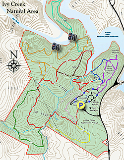
We crossed many creeks during the hike with small bridges at all of the crossings. Some of the hike also parallel Ivy Creek eventually emptying into the Rivanna River Reservoir. About every .25 to .50 miles there is a bench to rest on. Be sure to do the Peninsula Loop as that is where there are some great views of the creek and reservoir.

We hiked Ivy Creek Natural Area as a clockwise outer-loop. The hike begins at the main parking area, we headed south to the Red Trail that goes through a Native Grass Restoration field, in 0.1 miles turn left onto the Yellow Trail. The trail is well shaded from here until near the end of the hike. In 0.5 miles turn left onto the Red Trail and in 0.1 miles turn left onto the Green Trail. Over the next mile or so are multiple creek crossings. In 0.7 miles pass under a telephone line and in 0.1 miles turn once again onto the Red Trail. In 0.1 miles turn onto the Orange Trail and very quickly turn onto the left branch of the Orange Trail.

In 0.1 miles the Orange Trail will once again bear to the left, keeping you on the outer-loop of the trail system. The next 0.8 miles until the Peninsula Trail has a couple of views through the trees of Ivy Creek. Turn left onto the purple Peninsula Loop Trail which will have some great views of Ivy Creek and the Rivanna Reservoir, the loop is about 0.8 miles long. It was a little over-grown when we hiked it. After completing the loop, take a left onto the Orange Trail, go 0.2 miles and take a left onto the Red Trail.

Stay on the Red Trail for 0.5 miles, many intersections in this section, when in doubt continue to bear left until the Blue Trail with some more good views of the reservoir. Bear left on the Blue Trail for 0.3 miles and bear left onto the Purple Trail reaching the Hydraulic Overlook spur trail on your left very quickly. In the fall without leaves on the trees their may be a better view of the reservoir. Return from the spur trail and bear left back onto the Purple Trail. The next section goes through another native grass restoration area. In 0.2 miles reach the Paved Trail, continue past the education Bldg and information kiosk and reach the parking lot in 0.1 miles.

Pets

Dogs are not allowed.
Explore 35 trails near Charlottesville, VA

Know Before You Go

  • Ivy Creek Natural Area offers a 4.3-mile family-friendly hike with minimal elevation change and abundant wildlife sightings near Charlottesville, VA.
  • The outer-loop trail incorporates multiple intersecting trails, marked by color, with creek crossings, benches, and optional Peninsula Loop for reservoir views.
  • The trail passes through diverse environments like native grass restoration fields and shaded areas and includes a Hydraulic Overlook spur; dogs are not permitted.
Interactive topographic map for Ivy Creek Hike located in Charlottesville, VA. Click the "View Map" button to load GPS coordinates and trail markers.
Get directions
Distance
4.3 mi
Difficulty
Easy
Type
Loop
Est. Time
2.2 hrs
Elev. Gain
729'
Rating
0.0
Added
April 03, 2025
Updated
April 06, 2025

Weather Forecast

Loading...
Total Change
187'
Ascent
729'
Descent
727'
Loading...

Download the GPX Data for Offline Use

Supporters get exclusive access to download trail routes to the MyHikes app for offline use. Stay prepared on your adventure, even without an internet connection! Become a Supporter today to unlock this feature and hike with confidence.

Download Ivy Creek Hike GPX Data to the MyHikes Mobile App

Features

Water Source

Points of interest

  1. Parking

    38.091098, -78.493546
  2. Main Trailhead

    38.091033, -78.493431

Safety information

For your own safety: plan ahead, let someone know where you'll be, and hike at your own risk.

Hazards

Snakes (Rattlesnakes, Copperheads, others)
Poison Ivy or Poison Oak

Availability

All seasons

Surface type

Dirt

Trip Reports (Reviews)

Your opinion matters! Be the first to rate this trail.

Ready to help fellow hikers? Add a trip report to share your experience and provide valuable insights for other hikers!

No community routes found. To add your own hike as a Community Route for this Trail guide, leave a Trip Report with an attached GPX file.

Popular categories

Scenic mountain view representing vista trails
Vista trails
Scenic gorge of cascades representing waterfall trails
Waterfall hikes
Rugged mountain terrain representing summit trails
Summit trails
Scenic mountain view representing dog-friendly trails
Dog-friendly
Scenic campsite with a view representing camping trails
Camping trails
Appalachian Trail logo representing A.T. hikes
A.T. hikes

You May Also Like

25 Best Day Hikes in North Carolina - Discover the top 25 best day hikes in North Carolina, from breathtaking waterfalls to mountain peaks. Explore hidden gems, scenic views, and trails suitable for all skill levels, perfect for your next outdoor adventure.
Explore

25 Best Day Hikes in North Carolina

Discover the top 25 best day hikes in North Carolina, from breathtaking waterfalls to mountain peaks. Explore hidden gems, scenic views, and trails suitable for all skill levels, perfect for your next outdoor adventure.

Read
🍪 We use cookies to learn about site usage and to serve map tiles. You may block cookies manually in the browser. By continuing you agree. Learn more