Inspiration Point and Kaaterskill Falls are located in the Kaaterskill Wild Forest in Haines Falls, New York and is a moderate 5.6 mile loop hike.
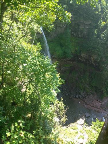
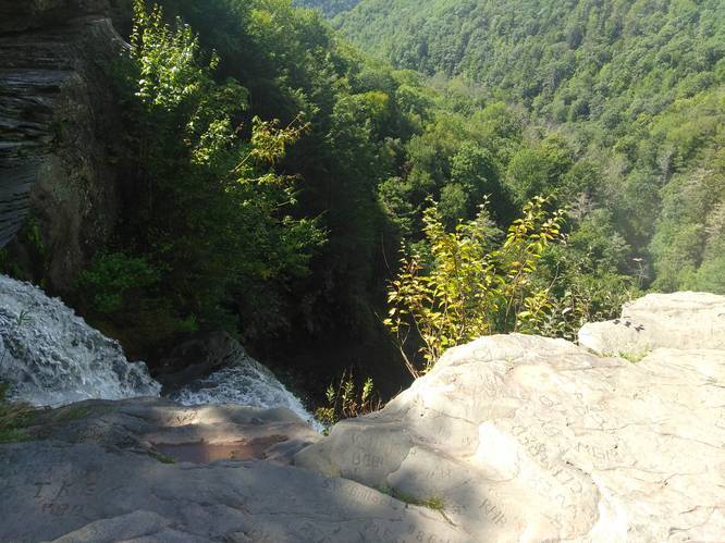
Kaaterkills Falls: The viewing platform overlooking Kaaterskill Falls is located roughly 0.2 miles from the parking lot down a smooth gravel trail, this is a very popular location and should be taken into consideration when planning a trip.
From the viewing platform at Kaaterskill Falls hike southeast down the main trail to a foot bridge which crosses Spruce Creek, turn left up the South Lake Access Road Trail for 0.1 miles and turn right onto the Schutt Road. The trail splits after 0.2 miles with the Yellow Horse Trail veering to the right.
Schutt Road seems to be the more popular option and heads towards South Mountain and the Catskill Mountain House Site. The Yellow Horse Trail dips below the ridge providing a northern loop to Inspiration Point. Both trails are wide, seemingly to accommodate a wagon in the past. The Yellow Horse Trail is less traveled due to some overgrown portions and more spider webs than one should have to hike through.
Follow the Yellow Horse Trail east for 1.1 miles, the Escarpment Trail will appear to the right and merge with the Yellow Horse Trail, take this right to head to Inspiration Point or continue on 0.1 miles to a trail junction heading towards South Mountain. You can head north up the Escarpment Trail to the summit of South Mountain and the Schutt Road Trail which will bring you west back to the parking lot, or east to Boulder Rock and the Catskill Mountain House Site.
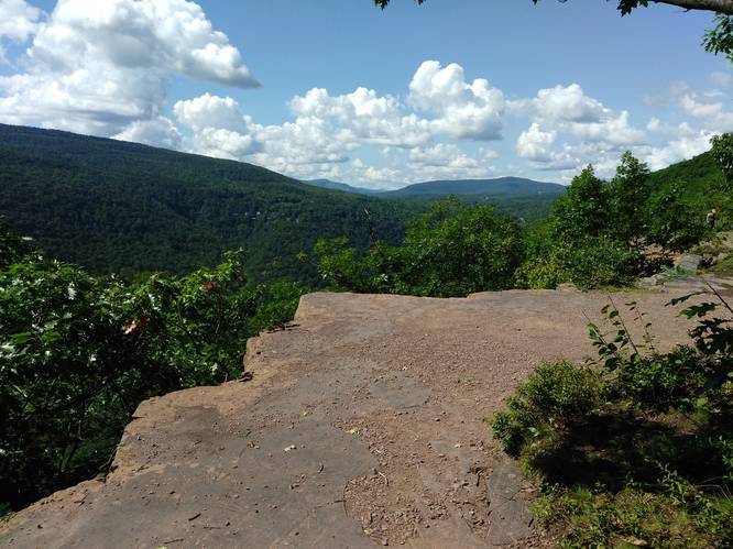
Inspiration Point: Taking a right onto the Escarpment Trail to Inspiration Point, follow the blue blazes along the edge of the ridge. There are several lookout points along this trail leading you to think each one may be at Inspiration Point. The trail is roughly 1 mile to the point. The trail is not as wide here and skirts along some edges but should not be considered difficult - moderate at best. Inspiration Point opens up to a large stone overlook with old etching dating back to the 1800s and offers a stunning view of the surrounding mountains and valley below.
Continue on the Escarpment Trail a short distance and you will find a short cutoff trail that connects back to the Yellow Horse Trail. This brief section has some larger boulders and rock faces but its very manageable. Take the Yellow Horse Trail back to Schutt Road and back to the parking lot.
Dogs are allowed on this trail.
Kaaterkills Falls: The viewing platform overlooking Kaaterskill Falls is located roughly 0.2 miles from the parking lot down a smooth gravel trail, this is a very popular location and should be taken into consideration when planning a trip.
From the viewing platform at Kaaterskill Falls hike southeast down the main trail to a foot bridge which crosses Spruce Creek, turn left up the South Lake Access Road Trail for 0.1 miles and turn right onto the Schutt Road. The trail splits after 0.2 miles with the Yellow Horse Trail veering to the right.
Schutt Road seems to be the more popular option and heads towards South Mountain and the Catskill Mountain House Site. The Yellow Horse Trail dips below the ridge providing a northern loop to Inspiration Point. Both trails are wide, seemingly to accommodate a wagon in the past. The Yellow Horse Trail is less traveled due to some overgrown portions and more spider webs than one should have to hike through.
Follow the Yellow Horse Trail east for 1.1 miles, the Escarpment Trail will appear to the right and merge with the Yellow Horse Trail, take this right to head to Inspiration Point or continue on 0.1 miles to a trail junction heading towards South Mountain. You can head north up the Escarpment Trail to the summit of South Mountain and the Schutt Road Trail which will bring you west back to the parking lot, or east to Boulder Rock and the Catskill Mountain House Site.
Inspiration Point: Taking a right onto the Escarpment Trail to Inspiration Point, follow the blue blazes along the edge of the ridge. There are several lookout points along this trail leading you to think each one may be at Inspiration Point. The trail is roughly 1 mile to the point. The trail is not as wide here and skirts along some edges but should not be considered difficult - moderate at best. Inspiration Point opens up to a large stone overlook with old etching dating back to the 1800s and offers a stunning view of the surrounding mountains and valley below.
Continue on the Escarpment Trail a short distance and you will find a short cutoff trail that connects back to the Yellow Horse Trail. This brief section has some larger boulders and rock faces but its very manageable. Take the Yellow Horse Trail back to Schutt Road and back to the parking lot.
Dogs are allowed on this trail.