-
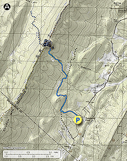
Mile 0.0 - From the small parking pull out on VA 610 head up the blue blazed Hunkerson Gap Trail as it passes through a relatively flat area. At mile 0.55 there is a small gully where the trail makes a sharp turn to the left. This section of the Hunkerson Gap Trail, before it joins the forestry road, is blazed both white and blue.
-
Mile 0.6 - Turn right uphill on the blue blazed Hunkerson Gap Trail/forestry road. There are several sink holes on the right side of the road 0.6 miles from turning onto the forestry road. These sink holes are formed when the limestone below is dissolved by groundwater, causing caverns and surface depressions to develop. The Great North Mountain area has a high concentration of limestone. Do not walk into the sink holes as the cavern ceilings can collapse.
-
Mile 1.7 - Turn left uphill where the blue blazed Hunkerson Gap Trail leaves the forestry road. From this point the trail becomes increasingly steeper, and 0.9 miles from leaving the forestry road there is a rock formation on the right side of the trail. From the top of these rocks there is a view of the valley towards Orkney Springs. Continue on the Hunkerson Gap Trail for another 0.2 miles to the ridge.
-
Mile 2.8 - Arrive at the 4-way intersection with the yellow blazed Church Rock Trail on the left and orange blazed North Mountain Trail on the right. The Hunkerson Gap Trail continues downhill on the western side of the mountain. Turn left/south on the yellow blazed Church Rock Trail for 0.1 miles.
-
Mile 2.9 - There is a small more open area with limited views to the east. This is the hike turn around point. Retrace your route to return. The Church Rock Trail continues to the south and connects with the Church Rock hike.
- Mile 5.8 - Arrive back at the parking pull out on VA 610.
Hunkerson Gap Hike
Know Before You Go
- Distance
- 5.6 mi
- Difficulty
- Hard
- Type
- Out-and-Back
- Est. Time
- 2.8 hrs
- Elev. Gain
- 1,413'
- Rating
- 0.0
- Added
- January 27, 2025
- Updated
- April 04, 2025
Weather Forecast
Don't let Google decide who you trust.


<strong>Trail map and elevation chart not rendering in print mode?</strong> Simply scroll to the trail map section, then try printing again!
395 m
431 m
431 m
Features
- Vista / Lookout Point
- Dogs
- Camping
- Water Source
Points of interest
-
Parking
38.757956, -78.843105 -
Main Trailhead
38.757956, -78.843105
Safety information
For your own safety: plan ahead, let someone know where you'll be, and hike at your own risk.
Markers
Blaze Color
BlueAvailability
Surface type
Trip Reports (Reviews)
Ready to help fellow hikers? Add a trip report to share your experience!


You may also like

25 Best Day Hikes in Virginia
Explore the top hikes in Virginia, from iconic trails in Shenandoah National Park to hidden gems in the Blue Ridge Mountains. Find your next unforgettable outdoor adventure.

25 Best Day Hikes in West Virginia
Discover 25 of the best day hikes in West Virginia, from scenic overlooks to wilderness trails—perfect for every level of hiker.

25 Best Day Hikes in North Carolina
Discover the top 25 best day hikes in North Carolina, from breathtaking waterfalls to mountain peaks. Explore hidden gems, scenic views, and trails suitable for all skill levels, perfect for your next outdoor adventure.

Best of the Alps: Hiking, Adventure & Scenery
Plan your ultimate European Alps adventure! Discover the best hiking trails, epic scenery, and villages in the Swiss Alps, Dolomites, Chamonix, and Lake Como.

