Loading...

🎉 Enjoy a Free 7-Day Supporter Trial and Unlock Exclusive Perks — No Credit Card Required. Learn more.

House Mountain Hike

Directions
Map
Pictures
Send to App
Distance:
8.0 Miles / 12.9 km
Type:
Out-and-Back
Difficulty:
Strenuous
Time to Hike:
4 hours
Features:
Surface Type:
Dirt
Town:
Lexington, Virginia
Directions:
37.81113, -79.53109
Added:
April 03, 2025
Updated:
April 06, 2025
Copy Trail Link Hiking this trail? Send a friend or family member a link to this trail guide for your own safety. Hike at your own risk (disclaimer)
Loading...
Loading...
1,753'

Total Change
2,604'

Ascent
2,423'

Descent

Download the Trail Route for Offline Use

Supporters get exclusive access to download trail routes to the MyHikes app for offline use. Stay prepared on your adventure, even without an internet connection! Become a Supporter today to unlock this feature and hike with confidence.

Send to App

House Mountain Hike

The House Mountain hike near Lexington Virginia is really two out-and-back hikes in one. Big House Mountain, with great views to the west from Goat Point Overlook, and Little House Mountain, with its spectacular views of the Shenandoah Valley to the northeast. Goat Point was named for a local goat that would look for handouts from hikers around 2011. Unfortunately the goat has not been seen in several years, but the climb to the overlook on Big House Mountain is definitely worth the effort.

Little House and Big House Mountains appear to tower out of the plains as they stand by themselves, separate from any other mountain range. The 950 acre House Mountain Preserve was purchased in 1989 through the efforts of the Rockbridge Area Conservation Council, the Virginia Outdoors Foundation, and many local residents, including Bill Stubbs a leader in conservation causes in the Rockbridge area for many years. The area is owned, and managed by the by the Virginia Outdoors Foundation. Volunteers contribute to the upkeep of the trails and parking area.

The saddle between Big House and Little House Mountains was originally a homestead, and more recently a orchard and pasture. With camping space for multiple tents, as well as a seasonal spring just past the shelter on Big House Mountain, this is a perfect place to take an overnight backpack.

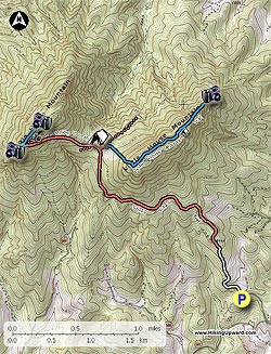
If you start at the parking area and hike both Big House and Little House mountains the total distance is 8.9 miles.

From the parking area head up unpaved VA643 and staying right uphill (private drive is left). Continue up VA643 (please respect private property) to the closed gate and trailhead 0.7 miles from the parking area.

House Mountain Trail
Out/Back 3.2mls - Moderate

From the trailhead and closed gate, start up the unblazed House Mountain Trail. The trail passes private property on the left for the first 0.5 miles. The remaining hike to the saddle becomes steeper and more rutted.

Big House Mountain Trail
Out/Back - 1.7mls - 740ft gain - Steep/Difficult

Continue to the west uphill on the unblazed Big House Mountain trail and in 100 yards pass a shelter and privy on the right. Just past the shelter the trail will split, remain right uphill as it becomes steeper then makes a hairpin turn to the right in 0.5 miles. At the hairpin turn, stay straight on the blue blazed trail where it becomes narrow, steep and rocky for the short 90 yard climb to the Big House Mountain ridgeline. Turn left at the ridge line following the faint trail for 30 yards to passing a small campsite, then arriving at the first vista to the west. Continue for another 25 yards to the main panoramic view at Goat Point Overlook on Big House Mountain.

Return along the ridge to where the trail begins to descend, but continue to bushwack along the ridgeline for 100 yards where there is a boulder canyon. Just inside the boulders is Tabletop Rock. Return to the intersection down with the blue blazed trail and retrace your steps back to the saddle between Big House and Little House Mountains.

Return to the saddle by retracing your route.

Little House Mountain Trail
Out/Back - 2.6mls - 940ft gain - Moderate+

The new Little House Mountain trail is now fully marked with standard vertical blue blazes from the saddle (just behind the two signs) all the way to the incredible overlook. This new trail was the solution to the very strenuous, straight up trail before. This trail is not mountain bike/horse friendly.

From the saddle the Little House Mountain trail starts from behind the signs. Follow the blue blazes as it gradually ascends the south-west side of the ridge, before making several switchbacks and climbing the last half mile to the ridgeline.

At the ridge follow the trail through a thick section of Mountain Laurel before turning left back to the north. In 0.2 miles the trail passes to the left of the main summit before beginning its descent to the overlook in another 0.7 miles.

Once passing around the main summit, the trail descends passing through a rock scree, then shortly afterward reach a small campsite. The blue blazed trail continues downwards and ends at the panoramic Little House Mountain overlook. Return to the saddle by retracing your route.
Explore 37 trails near Lexington, VA
  1. Parking

    37.81113, -79.53109
  2. Main Trailhead

    37.81113, -79.53109
No community routes found. To add your own hike as a Community Route for this Trail guide, leave a Trip Report with an attached GPX file.

Hazards

Ticks - Lyme Disease More Info (CDC)
Snakes
Poison Ivy/Oak
Rockfalls / Ledges / or Scrambles

Seasons

All

Trip Reports

Trail Guide By:
HikingUpward user profile picture
8.0 miles / 12.9 km

Weather Forecast

In Lexington, VA

Explore Hiking Trails

You May Also Like

New York's Best Waterfalls - Whether you're planning a day hike, roadside stop, or a leisurely short walk, this guide provides hikers, travelers, and locals alike with 63 different locations to over 100 scenic waterfalls to help plan your next adventure!
Explore

New York's Best Waterfalls

Whether you're planning a day hike, roadside stop, or a leisurely short walk, this guide provides hikers, travelers, and locals alike with 63 different locations to over 100 scenic waterfalls to help plan your next adventure!

Read
25 Best Day Hikes in North Carolina - Discover the top 25 best day hikes in North Carolina, from breathtaking waterfalls to mountain peaks. Explore hidden gems, scenic views, and trails suitable for all skill levels, perfect for your next outdoor adventure.
Explore

25 Best Day Hikes in North Carolina

Discover the top 25 best day hikes in North Carolina, from breathtaking waterfalls to mountain peaks. Explore hidden gems, scenic views, and trails suitable for all skill levels, perfect for your next outdoor adventure.

Read

Before you boogie...

Find our trail guides useful? Consider becoming a Supporter to unlock perks!

MyHikes is an indie platform that makes exploring public trails easier for everyone. The platform has no investors, no ads, and is owned and operated by one person, Dave Miller. Dave has personally mapped and written over 1,800 trail guides on MyHikes for the public to explore. MyHikes has helped millions outdoor enthusiasts plan their next adventure.

But it takes a lot of time 🕦, money 💰, work, and espresso shots ☕ to run MyHikes, including hiking , mapping , writing , and publishing new trails with high-quality (accurate) information... along with software engineering (coding) the platform like building new features, website and mobile app development (iOS and Android), site maintainance . and much much more.

Supporters unlock website and mobile app perks with an annual one-time payment of $25 (you renew) 😎👍. Or you can simply make a Donation of your choice. Otherwise, you can support us by telling your friends about MyHikes - both quick and free 🎉

Admin user profile picture

Dave Miller
MyHikes Founder