Loading...

WINTER SALE! 50% OFF Supporter Accounts — now through January 31st. Learn More.

Hoop Hole Hike

Hoop Hole is located about 30 miles west of Lexington VA. on the eastern side of Pine Mountain. The Hoop Hole circuit is actually two loops, the lower 3.8 mile loop follows two streams and is the more scenic with rhododendron and small swimming holes, and can be combined with the upper loop to make a 9.7 mile circuit.

The Hoop Hole circuit can also be accessed from the Roaring Run Recreation Area by taking the out/back Iron Ore trail. This will add 4.8 miles and make a total circuit hike of 14.5 miles from Roaring Run.

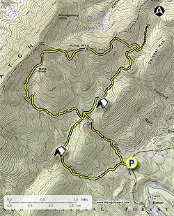
The hiking directions on this page are for the 9.7 mile circuit starting at VA615/Craig Creek Rd. The yellow blazed Hoop Hole trail starts from the left of the parking area passing the informational kiosk, and in 250 yards reaches the intersection for the lower loop.

Turn left as the trail heads uphill and begins to follow Hipes Branch Creek. In 1.3 miles from the intersection arrive at the best camping spot on the circuit on the banks of Hipes Branch Creek. Continue uphill for 0.7 miles and arrive at the intersection of the upper loop and cut over trail.

NOTE. As of July 2010 the upper section of the trail, before arriving at the ridge, has a significant amount of Stinging Nettles. Long pants are highly recommended.

Turn left uphill on the upper loop as it winds up the valley. As you get near the top there will be a small saddle between Bald Knob and Pine Mountain. Stay to the left to remain on the yellow blazed upper loop trail.

After arriving at the ridge follow the trail to the right where there are several views through the trees to the east. The trail will follow the ridge for 1.2 miles before beginning the descent on the eastern side of Pine Mountain. In 0.5 miles after stating the decent reach the yellow blazed Iron Ore Trail that leads to Roaring Run in 2.4 miles.

Turn right remaining on the upper loop trail and continue descending for 1.5 miles to a large group campsite situated on a spur. In another 0.4 miles reach the intersection of the lower and cut over trails. Stay left downhill as the lower loop trail crosses over Stony Run several times then returns to the beginning of the loop in 1.2 miles. Turn left and return to the parking area in 250 yards.

Explore 30 trails near Eagle Rock, VA

Know Before You Go

  • Hoop Hole Trail in Eagle Rock, VA offers scenic loop hikes ranging from 3.8 miles (lower loop) to 9.7 miles (combined loops) starting from VA615/Craig Creek Rd.
  • The 9.7-mile circuit features a climb to a ridge with eastern views, but hikers should be aware of stinging nettles on the upper section and consider wearing long pants.
  • An optional extension via the Iron Ore Trail from Roaring Run Recreation Area adds 4.8 miles (one way) for a 14.5-mile total hike.
Interactive topographic map for Hoop Hole Hike located in Eagle Rock, VA. Click the "View Map" button to load GPS coordinates and trail markers.
Get directions
Distance
8.4 mi
Difficulty
Hard
Type
Loop
Est. Time
4.2 hrs
Elev. Gain
2,091'
Rating
2.9
Added
February 28, 2025
Updated
April 05, 2025

Weather Forecast

Loading...
Total Change
2,022'
Ascent
2,091'
Descent
2,091'
Loading...

Download the GPX Data for Offline Use

Supporters get exclusive access to download trail routes to the MyHikes app for offline use. Stay prepared on your adventure, even without an internet connection! Become a Supporter today to unlock this feature and hike with confidence.

Download Hoop Hole Hike GPX Data to the MyHikes Mobile App

Features

Vista / Lookout Point
Dogs
Mountain Summit
Camping
Water Source

Points of interest

  1. Parking

    37.673111, -79.917592
  2. Main Trailhead

    37.672849, -79.917233

Safety information

For your own safety: plan ahead, let someone know where you'll be, and hike at your own risk.

Hazards

Snakes (Rattlesnakes, Copperheads, others)
Poison Ivy or Poison Oak

Markers

Blaze Color

Yellow

Availability

All seasons

Surface type

Dirt

Trip Reports (Reviews)

Rated 2.86 out of 5 based on 7 ratings.

Ready to help fellow hikers? Add a trip report to share your experience and provide valuable insights for other hikers!

By: Troop478
8.4 miles / 13.5 km
October 26, 2019
We took our Girl Scout troop for their first ever backpacking trip to the lower loop and spent the night at the recommended site. This was a great hike to introduce the kids to backpacking long enough to be a challenge, but not so hard as to be discouraging. There are numerous stream crossings, but the trail is well maintained and well blazed.
Legacy Review
By: Steve O.
8.4 miles / 13.5 km
August 07, 2015
We backpacked the lower loop only in a one-night mini trip, going in on Friday and completing the 3.8 mile circuit on Saturday. Total solitude. We did not see another human on either day. The campsite this site recommended was outstanding. The woods are beautiful with tall trees and not a lot of underbrush, except for the rhododendron along the creeks. I thought the trail was well-maintained and well-blazed. We were in the area on business so it worked out for us to do this excursion hike and explore the area. Water levels were relatively low, making the stream crossings easy. For solitude, peace and natural beauty, this hike is a winner, especially if your time is limited or if you don't want to tackle a lot of miles.
Legacy Review
By: Doc Faw
8.4 miles / 13.5 km
July 04, 2014
Lower loop was fantastic on July 3rd. Upper loop was great until the boulder fields with the stinging nettles which occupied 3 sections totaling at least 3/4 mile. Left parking lot at 9:15 am. Returned at 5:30 pm. The trail could have followed the crest of Pine Mountain and circumvented the nettles.
Legacy Review
No community routes found. To add your own hike as a Community Route for this Trail guide, leave a Trip Report with an attached GPX file.

Popular categories

Scenic mountain view representing vista trails
Vista trails
Scenic gorge of cascades representing waterfall trails
Waterfall hikes
Rugged mountain terrain representing summit trails
Summit trails
Scenic mountain view representing dog-friendly trails
Dog-friendly
Scenic campsite with a view representing camping trails
Camping trails
Appalachian Trail logo representing A.T. hikes
A.T. hikes

You May Also Like

25 Best Day Hikes in North Carolina - Discover the top 25 best day hikes in North Carolina, from breathtaking waterfalls to mountain peaks. Explore hidden gems, scenic views, and trails suitable for all skill levels, perfect for your next outdoor adventure.
Explore

25 Best Day Hikes in North Carolina

Discover the top 25 best day hikes in North Carolina, from breathtaking waterfalls to mountain peaks. Explore hidden gems, scenic views, and trails suitable for all skill levels, perfect for your next outdoor adventure.

Read
🍪 We use cookies to learn about site usage and to serve map tiles. You may block cookies manually in the browser. By continuing you agree. Learn more