Loading...

Distance:
0 Miles / 0 km
Type:
Out-and-Back
Difficulty:
Easy
Time to Hike:
~5 minutes
Features:
Surface Type:
Universal Access
Park:
Dixie National Forest
Town:
Boulder, Utah
Directions:
38.011629, -111.358858
Added:
September 26, 2023
Updated:
October 04, 2023
Loading...
Loading...
8 '

Total Change
8 '

Ascent
8 '

Descent

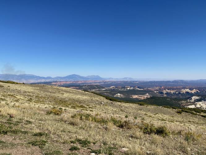
The Homestead Overlook at Dixie National Forest near Boulder, Utah is a universally-accessible roadside vista that features views southward toward the Grand Staircase-Escalante National Monument.

This is not a hike, but rather a quick roadside stop that can be enjoyed on a long road trip through southern Utah. Visitors will find sweeping views facing south. Most of the landscape within the view exists within the Grand Staircase-Escalante National Monument, but at the foreground the land sits within Dixie National Forest.

Universal Access
This vista includes a universally-accessible paved pathway that runs along the southeastern section of the parking lot.

Parking
Visitors will find a small parking turnout at the coordinates provided.

Pets
Dogs are allowed if leashed and must be cleaned up after.

Explore 25 trails near Boulder, UT
  1. Parking

    38.011629, -111.358858
  2. Main Trailhead

    38.011601, -111.358824
  3. Homestead Overlook at Dixie National Forest

    38.011586, -111.358794
    Homestead Overlook at Dixie National Forest
No community routes found. To add your own hike as a Community Route for this Trail guide, leave a Trip Report with an attached GPX file.

Hazards

Snakes

Seasons

All

Photo Albums

2 Trip Reports

No Star-Ratings
Write-up by:
Admin user profile picture
0 miles / 0 km
Trail added
September 26, 2023
Hiked on
September 26, 2023
Updated on
October 04, 2023
0 miles / 0 km
September 26, 2023
Hiking

Weather Forecast

In Boulder, UT

Explore Hiking Trails

New Hikes

Brittlebank Park Pier Trail
0.2 Miles
0.3 km
Easy
Out-and-Back
Mt. Morris Dam Overlook
3.3 Miles
5.3 km
Easy
Out-and-Back
Upper Rattler Run Falls
1.9 Miles
3.1 km
Hard
Out-and-Back
Lower Ammonoosuc Falls Trail
1.1 Miles
1.8 km
Easy
Out-and-Back

Before you leave...

MyHikes is an indie web platform aimed to make exploring public trails easier for everyone. The site has no investors and is owned and operated by one person, Dave Miller (Founder & Admin). As the Founder, main contributor, and doer-of-all-things for MyHikes, I share my trips with over-detailed write-ups for fun on a volunteer basis and I believe that public trail information should be available to everyone.

It takes a lot of time 🕦, money 💰, and effort (including espresso shots ☕) to run MyHikes, including hiking , mapping , writing , and publishing new trails with high-quality content... along with building new features, moderating, site maintainance, and app development for iOS and Android . I simply ask that if you find MyHikes' trail guides helpful to please consider becoming a Supporter to help keep the site, iOS, and Android apps available to everyone.

Supporters unlock website and in-app perks with a one-time payment of $25 (you renew) 😎👍. Or you can simply make a Donation of your choice without a MyHikes user account. Otherwise, telling your friends about MyHikes is the next-best thing - both quick and free 🎉

Thanks for visiting MyHikes and have a great hike!️

Admin user profile picture

Dave Miller
MyHikes Founder & Admin