Loading...

๐ŸŽ‰ Enjoy a Free 7-Day Supporter Trial and Unlock Exclusive Perks โ€” No Credit Card Required. Learn more.

Hogback Mountain Hike

Directions
Map
Pictures
Send to App
Distance:
7.0 Miles / 11.3 km
Type:
Loop
Difficulty:
Moderate
Time to Hike:
3 hours, ~30 minutes
Features:
Appalachian Trail hike
Surface Type:
Dirt
Park:
Shenandoah National Park
Town:
Rileyville, Virginia
Directions:
38.750584, -78.294147
Added:
March 18, 2025
Updated:
April 06, 2025
Copy Trail Link Hiking this trail? Send a friend or family member a link to this trail guide for your own safety. Hike at your own risk (disclaimer)
Loading...
Loading...
894'

Total Change
1,203'

Ascent
1,203'

Descent

Download the Trail Route for Offline Use

Supporters get exclusive access to download trail routes to the MyHikes app for offline use. Stay prepared on your adventure, even without an internet connection! Become a Supporter today to unlock this feature and hike with confidence.

Send to App

Hogback Mountain Hike

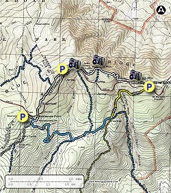
The Hogback Mountain hike, with its spectacular views west towards the Massanutten ranges, is located in an area of the SNP that has several beautiful hikes including Piney Branch and Little Devil Stairs. With just over 1,200ft of vertical gain and 7.5 miles, this is a pleasant moderate day hike.
  • Mile 0.0 โ€“ From the parking area (located 75 yards off Skyline Drive) walk back towards Skyline Drive and the Piney Branch trailhead. From the kiosk trailhead, start down the blue blazed Piney Branch Trail as it passes through Mountain Laurel before reaching the 4-way intersection with the Appalachian Trail (A.T.).
  • Mile 0.2 โ€“ Cross over the A.T. and continue down the Piney Branch Trail as it continues its descent. The Piney Branch Trail will cross the upper portion of Piney River then reach the intersection of the Pole Bridge Link Trail.
  • Mile 1.7 โ€“ Turn left on the blue blazed Pole Bridge Link Trail for 0.4 miles and arrive at the intersection of the Sugarloaf Trail.
  • Mile 2.2 โ€“ Continue straight on the Pole Bridge Link Trail continuing around the mountain where the trail ends at the intersection of the Keyser Fire Road and Little Devil Stairs Trail.
  • Mile 3.0 โ€“ Turn left uphill on the yellow blazed Keyser Fire Road as it gradually ascends to Skyline Drive where the road ends at the Keyser Fire Road parking area.
  • Mile 4.0 โ€“ Cross Skyline Drive and follow the connector Trail for 60 yards to the intersection of the white blazed Appalachian Trail (A.T.).
  • Mile 4.1 โ€“ Turn left on the A.T. climbing Little Hogback Mountain. As the A.T. levels off look for the vista point directly ahead with beautiful views to the north and west. The knob to the south is Hogback Mountain.
  • Mile 4.4 โ€“ Continue on the AT descending towards the Skyline Drive Overlook. Just before the overlook parking area turn right remaining on the A.T. and passing through a clear cut. At this point the A.T. makes its steepest climb of the hike gaining over 300ft with several switchbacks on the way to the ridge. After reaching the ridge, the A.T. levels off and passes a small connector trail that leads to a Spring. Pass a nice view, then in 40 yards reach the main vista on Hogback Mountain.
  • Mile 5.4 โ€“ From the main Hogback Mountain vista continue on the Appalachian Trail as it winds around the back of the mountain, through a stand of Mountain Laurel, then crosses Skyline Drive and passes the intersection of the Sugarloaf Trail.
  • Mile 5.7 โ€“ From the Sugarloaf Trail intersection the A.T. will climb for a short time where the last good view point of the hike overlooks the Hogback Mountain Skyline Drive overlook area. Now continue downhill and shortly the A.T will again cross Skyline Drive and pass a parking area.
  • Mile 6.0 โ€“ After passing the parking area the A.T. will cross over a small rise, pass to the left of another trail intersection, then cross Skyline Drive for the last time. Continue downhill on the A.T. and in 0.2 miles from crossing Skyline Drive arrive back at the intersection of the Piney Branch Trail.
  • Mile 6.7 โ€“ Turn right uphill on the Piney Branch Trail for 0.2 miles back to the trailhead and kiosk.
  • Mile 7.0 - Arrive back at the Piney Branch Trail parking area.
Explore 97 trails near Rileyville, VA
  1. Parking

    38.750584, -78.294147
  2. Main Trailhead

    38.749531, -78.294282
No community routes found. To add your own hike as a Community Route for this Trail guide, leave a Trip Report with an attached GPX file.

Hazards

Ticks - Lyme Disease More Info (CDC)
Snakes
Poison Ivy/Oak

Seasons

All

Trip Reports

Trail Guide By:
HikingUpward user profile picture
7.0 miles / 11.3 km

Weather Forecast

In Rileyville, VA

Explore Hiking Trails

You May Also Like

New York's Best Waterfalls - Whether you're planning a day hike, roadside stop, or a leisurely short walk, this guide provides hikers, travelers, and locals alike with 63 different locations to over 100 scenic waterfalls to help plan your next adventure!
Explore

New York's Best Waterfalls

Whether you're planning a day hike, roadside stop, or a leisurely short walk, this guide provides hikers, travelers, and locals alike with 63 different locations to over 100 scenic waterfalls to help plan your next adventure!

Read
25 Best Day Hikes in North Carolina - Discover the top 25 best day hikes in North Carolina, from breathtaking waterfalls to mountain peaks. Explore hidden gems, scenic views, and trails suitable for all skill levels, perfect for your next outdoor adventure.
Explore

25 Best Day Hikes in North Carolina

Discover the top 25 best day hikes in North Carolina, from breathtaking waterfalls to mountain peaks. Explore hidden gems, scenic views, and trails suitable for all skill levels, perfect for your next outdoor adventure.

Read

Before you boogie...

Find our trail guides useful? Consider becoming a Supporter to unlock perks!

MyHikes is an indie platform that makes exploring public trails easier for everyone. The platform has no investors, no ads, and is owned and operated by one person, Dave Miller. Dave has personally mapped and written over 1,800 trail guides on MyHikes for the public to explore. MyHikes has helped millions outdoor enthusiasts plan their next adventure.

But it takes a lot of time ๐Ÿ•ฆ, money ๐Ÿ’ฐ, work, and espresso shots โ˜• to run MyHikes, including hiking , mapping , writing , and publishing new trails with high-quality (accurate) information... along with software engineering (coding) the platform like building new features, website and mobile app development (iOS and Android), site maintainance . and much much more.

Supporters unlock website and mobile app perks with an annual one-time payment of $25 (you renew) ๐Ÿ˜Ž๐Ÿ‘. Or you can simply make a Donation of your choice. Otherwise, you can support us by telling your friends about MyHikes - both quick and free ๐ŸŽ‰

Admin user profile picture

Dave Miller
MyHikes Founder