Loading...

๐ŸŽ‰ Enjoy a Free 7-Day Supporter Trial and Unlock Exclusive Perks โ€” No Credit Card Required. Learn more.

Hoffler Creek Hike

Directions
Map
Pictures
Send to App
Distance:
2.1 Miles / 3.4 km
Type:
Loop
Difficulty:
Easy
Time to Hike:
1 hour
Features:
Surface Type:
Dirt
Town:
Portsmouth, Virginia
Directions:
36.893083, -76.396009
Added:
April 03, 2025
Updated:
April 06, 2025
Copy Trail Link Hiking this trail? Send a friend or family member a link to this trail guide for your own safety. Hike at your own risk (disclaimer)
Loading...
Loading...
12'

Total Change
8'

Ascent
16'

Descent

Download the Trail Route for Offline Use

Supporters get exclusive access to download trail routes to the MyHikes app for offline use. Stay prepared on your adventure, even without an internet connection! Become a Supporter today to unlock this feature and hike with confidence.

Send to App

Hoffler Creek Hike

This was our first venture into the Tidewater area to do a hike. We were invited by the Hoffler Creek Programs Director to come and take a look at the good work they are doing and hike their trails. We went on a snowy Saturday which made it cool to see the multitiude of animal tracks on the trails. Their mission is โ€œTo conserve the last parcel of wilderness in the Hoffler Creek watershed for environmental education, research and recreation consistent with good stewardship.โ€

If you live anywhere close to Portsmouth, this is a worthwhile preserve to visit. Make sure you visit the Oyster Pier and Reef where they have reclaimed (using oyster shells) 200' of the creek bank that was badly eroding. If you love water, you'll love this hike!

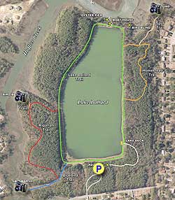
There are multiple ways Hoffler Creek can be hiked with most trails intersecting the main Lake Ballard Trail. Be sure to stop at the headquarters and pick up a Bird Checklist, over 200 species of Birds have been observed at least once a year in the Preserve. We started our hike just behind the Pavilion on the far side of parking lot.

  • Mile 0.0 โ€“ Start hike on the yellow blazed Kid's Trail
  • Mile 0.2 โ€“ Turn right on Lake Ballard Trail. Directly in front of you will be the Lake Deck for a view of Lake Ballard, a reclaimed VDOT borrow pit.
  • Mile 0.3 โ€“ Turn right on white blazed Homestead Trail
  • Mile 0.5 โ€“ Intersection of out and back trail to Willet Blind, bear right towards Willet Blind
  • Mile 0.6 โ€“ Willet Blind
  • Mile 0.8 โ€“ Retrace steps and bypass 1st intersection until you again reach the Lake Ballard Trail, bear right.
  • Mile 0.9 โ€“ Reach Memorial Blind on right just off the trail.
  • Mile 1.0 โ€“ Oyster Pier, Oyster Reef, Kayak Dock, and Lab on the right. Kayaks can be rented during warmer months. Continue on Lake Ballard Trail.
  • Mile 1.3 Turn right onto red blazed Riparian Trail and in 0.1 miles take short spur trail to White Bird Blind. Retrace steps to intesection and bear right back onto the Riparian Trail.
  • Mile 1.7 โ€“ Turn right onto blue blazed Blue Bird Trail for out and back to Saltmarsh Deck.
  • Mile 1.8 โ€“ Saltmarsh Deck, retrace your steps and stay on the Blue Bird Trail until you reach the Lake Ballard Trail.
  • Mile 2.0 โ€“ Lake Ballard Trail, bear right
  • Mile 2.1 โ€“ Turn right towards the Headquarters Building, where hike ends.
  1. Parking

    36.893083, -76.396009
  2. Main Trailhead

    36.893083, -76.396009
No community routes found. To add your own hike as a Community Route for this Trail guide, leave a Trip Report with an attached GPX file.

Hazards

Ticks - Lyme Disease More Info (CDC)
Snakes
Poison Ivy/Oak

Seasons

All

Trip Reports

Trail Guide By:
HikingUpward user profile picture
2.1 miles / 3.4 km

Weather Forecast

In Portsmouth, VA

Explore Hiking Trails

You May Also Like

New York's Best Waterfalls - Whether you're planning a day hike, roadside stop, or a leisurely short walk, this guide provides hikers, travelers, and locals alike with 63 different locations to over 100 scenic waterfalls to help plan your next adventure!
Explore

New York's Best Waterfalls

Whether you're planning a day hike, roadside stop, or a leisurely short walk, this guide provides hikers, travelers, and locals alike with 63 different locations to over 100 scenic waterfalls to help plan your next adventure!

Read
25 Best Day Hikes in North Carolina - Discover the top 25 best day hikes in North Carolina, from breathtaking waterfalls to mountain peaks. Explore hidden gems, scenic views, and trails suitable for all skill levels, perfect for your next outdoor adventure.
Explore

25 Best Day Hikes in North Carolina

Discover the top 25 best day hikes in North Carolina, from breathtaking waterfalls to mountain peaks. Explore hidden gems, scenic views, and trails suitable for all skill levels, perfect for your next outdoor adventure.

Read

Before you boogie...

Find our trail guides useful? Consider becoming a Supporter to unlock perks!

MyHikes is an indie platform that makes exploring public trails easier for everyone. The platform has no investors, no ads, and is owned and operated by one person, Dave Miller. Dave has personally mapped and written over 1,800 trail guides on MyHikes for the public to explore. MyHikes has helped millions outdoor enthusiasts plan their next adventure.

But it takes a lot of time ๐Ÿ•ฆ, money ๐Ÿ’ฐ, work, and espresso shots โ˜• to run MyHikes, including hiking , mapping , writing , and publishing new trails with high-quality (accurate) information... along with software engineering (coding) the platform like building new features, website and mobile app development (iOS and Android), site maintainance . and much much more.

Supporters unlock website and mobile app perks with an annual one-time payment of $25 (you renew) ๐Ÿ˜Ž๐Ÿ‘. Or you can simply make a Donation of your choice. Otherwise, you can support us by telling your friends about MyHikes - both quick and free ๐ŸŽ‰

Admin user profile picture

Dave Miller
MyHikes Founder