As of August 2024, the area where the Public Stargazing Program were being held including the amphitheater and viewer seating, and the parking area is under construction. These section of the park are closed. There appears to be an massive effort underway to improve these park amenities.
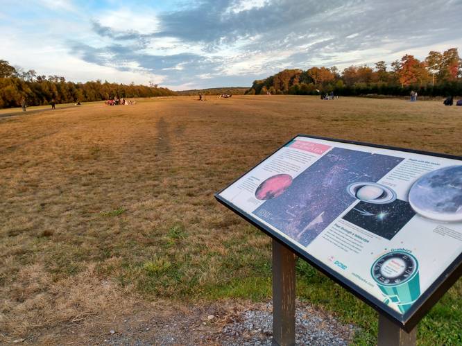
In today's world, the Cherry Spring State Park is a busy place with lots of recreational opportunities including public Stargazing Programs, a Woodsman's Show, and an overnight Astronomy Observation field. This area has become a haven for astronomers, and is on State Route 44 at Cherry Springs State Park in Potter County, Pennsylvania.
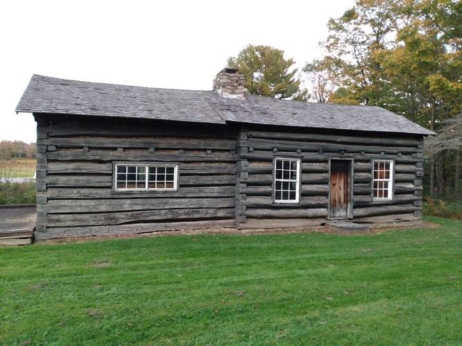
Among the array of the modern park amenities, sits a rather odd, older-looking structure. This Historic Cherry Springs Tavern, at the Cherry Springs State Park, is a replica of the long gone original and was built by the CCC in the 1930's (or maybe it was built by German POWs during WWII in the 1940's). The CCC Lyman Run Camp S-88 was also used to house POWs during WWII. Anyway it got built, and it is in the process of being saved and restored versus being torn down, as it's current condition is in need of repair. Let's hope that a plan is carried forward, as we certainly want to encourage the historic preservation of this CCC-era hand-crafted building.
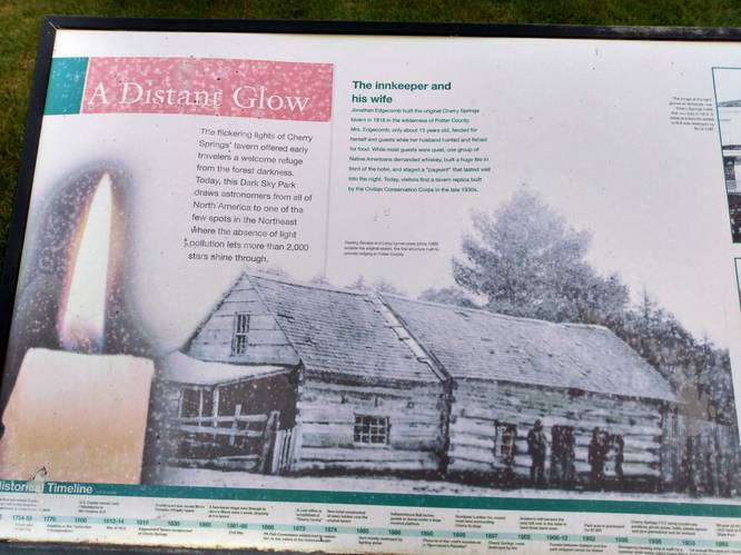
In a much earlier time, the glow of a candle from the original Cherry Springs Tavern beckoned the lonely traveler to this place of shelter in the seemly-boundless wilderness of that time. History tells us that in 1818, Jonathan Edgecomb constructed the original log house along the Jersey Shore Pike in dark sky wilderness that was once Potter County. This byway is now known as the Highway to the Stars, and Cherry Springs State park is Potter County's most visited attraction.
Trails
This structure is located just off of the State Route 44, and can be seen from the public roadway.
Maintained pathways lead to the picnic area that is about 500 feet from the Cherry Springs State Park visitors parking near the Night Sky Public Viewing. By way of these pathways, the visitor can complete a short loop by walking to find the picnic area and then continuing on toward the Historic Cherry Springs Tavern, which is accessible by crossing the grassy lawn along State Route 44, and is about another 500 feet beyond the picnic area.
The picnic area has picnic tables and charcoal grills located on the open hill-side just before reaching the location of the Historic Cherry Springs Tavern. There's an Information Kiosk and restroom facilities near the visitors parking area. An information display about the original Cherry Springs Tavern in located in the grassy area beyond the picnic area, and just across the rustic campground access road on the way to the Historic Cherry Springs Tavern.
Hike Description
No real hiking is required to visit this Historic Cherry Springs Tavern. Visitors must walk less than one-quarter mile to get to the Historic Cherry Springs Tavern from the visitors parking area. The walking surface starts as a gravel pathway and then becomes a grassy lawn, and is mostly flat
Parking
Hikers will find a very large visitors parking area near by the coordinates provided.
Pets
Park policy allows Pets on the grounds except for the Astronomy Observation Area and the campground.
Biking
Biking is allowed along all of these multi-use trails and roads in the area except for the STS. Additionally, horses are not allowed along the STS.
Camping and Backpacking
Although camping is allowed along trails in the Susquehannock State Forest, PA where state forest rules permit back-country / dispersed / primitive camping. This structure just off of State Route 44, and is not suitable Backpacking. The Susquehannock Trail System aka STS is by far the best place to backpack in this area; but it would be best for the camper to park at another pre-defined parking area for any extended hikes or overnight camping trips.
Hikers can find overnight parking for extended hiking trips at the Bureau of Forestry headquarters on US Route 6 on top of Denton Hill. The lot is large enough to hold dozens of vehicles with some amenities including maps and informational kiosks, and restrooms, and serves as the "Northern Gateway" which provides access to the northern portion of the STS loop.. See Duck Ponds Short Loop for extended trip parking coordinates and details to find the route to the STS.
Cherry Spring State Park offers rustic campsites within the park on a first come, first serve bases, and reservations are needed and can be made at www.visitPAparks.com.
History and Historical Points of Interest
Dense forests of magnificent white pine, hemlock and hardwoods grew here in Potter County for many decades. In the late 1800's and early 1900's, industrial saw mills, tanneries, and chemical plants were established, using wood or bark as raw materials which brought rapid population increases. As the hillsides became barren, the population spiraled downward with much of the deforested timberland abandoned. Before than, Native Americans had passed through the forested wilderness on hunting expeditions.
The Historic Cherry Springs Tavern is a replica of the original and was constructed during the Great Depression by the Civilian Conservation Corps.
Jonathan Edgecomb, an early settler in Potter County, constructed the original log house in 1818.
The Cherry Springs Airport, a small general aviation airport
operated between 1935 and 2007. It is now the star gazing field for star
watchers arriving by automotive vehicles instead of those coming here on hunting party footpath, wagon trail or flying aircraft. Where the Public Stargazing Program is held today there is a large open field on the mountain plateau. The Cherry Springs Star Gazing Field was once an airfield built in 1935 by the state of Pennsylvania Department of Forest and Waters (now known as the DCNR). The workers cleared 40 acres which was first used only as an emergency landing airfield but later become an active FAA airport with a grass landing strip. This airport was closed n 2007, when the star gazing amenities were built.