The Duck Pond Short Loop at Susquehannock State Forest near Coudersport, Pennsylvania is an easy 2.8-mile circuit hike that follows several named trails on top of Denton Hill. These well maintained pathways are mainly intended for the cross-county skier, but makes for nice forest walk on fairly flat terrain for hiking to an open-meadow wildlife viewing area.
Trails
This loop includes several named trails in a counter-clockwise order: Billy Lewis Trail (red blazes), Duck Pond Loops (blue blazes), and the White Line Trail (Orange STS Blazes and blue blazes). This route intersects with the Ridge Trail (Orange STS Blaze) which begins the 84-mile STS circuit.
Hike Description
This hike begins at the overnight parking at the coordinates provided at the Bureau of Forestry headquarters on US Route 6 and follows the Billy Lewis Trail to the south to the Duck Pond Loops. The Duck Pond Short Loop was then followed to wind the hiker back to the parking spot as a short counter-clockwise circuit.
There are plenty of trail signs and trail markers along the way to make this route fairly easy to follow. However, there are multiple trails and some forest service roads in the area. So, it is a good idea to carry a trail map, and consul your trail map often to stay on route.
Billy Lewis Trail
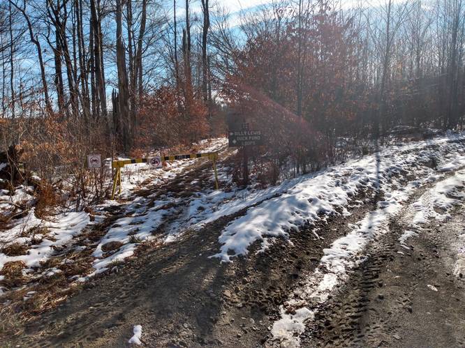
The Billy Lewis Trail is followed for 0.9 miles, which treks through the woods and leads the hiker to the Duck Pond Loops. A small wooden sign engraved "Duck Pond Loops" and arrow pointing to the left stands where the Duck Pond Loops branch away from the Billy Lewis Trail. The Billy Lewis Trail is an one-way multi-use trail that continues beyond this point to the south for an additional 7 miles evidently reaching the Patterson State Park.
Duck Pond Meadow Vistas - Mile 0.9
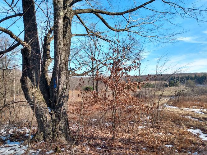
At mile 0.9, is where this trek bends to the east on the Duck Pond Loops. Within a short distance (with a few hundred feet) the hiker reaches a bluff that overlooks a meadow with a couple of small marshy ponds located below a sizeable wildlife food plot planted in turnips, a cool-season annual, and favorite browse of white deer. On this hike, in late November in the midst of hunting season, no deer were out in the open to be seen. And, no ducks were swimming anywhere hereabouts on the partly frozen wetlands at this time of year. However, the field afforded the hiker a vista from a mountain summit vantage point on a sunny late-autumn day and certainly gave a picturesque highlight to take in on this hike.
Duck Pond Short Loop - Mile 1.2
Around mile 1.2, hikers will find an engraved sign for "Duck Pond Short Loop" to show where to turn left to head north toward back Bureau of Forestry headquarters on US Route 6. This leg of the hike consists of a less-than-a-mile nature walk treks through the woods and leads the hiker to the starting point of STS 85-mile hiking trail. This section of the Duck Pond Short Loop steps through a hardwood forest with some small easy-to-cross streams and transverses along on well-maintained pathways that are easy to follow.
STS Trail Junction - Mile 2.1
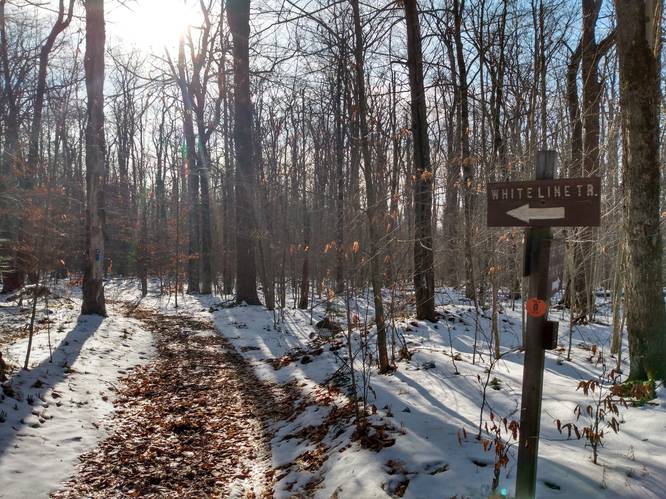
Around mile 2.1, the Duck Pond Short Loop trail will reach the White Line Trail (Orange STS Blazes and blue blazes). This is also the junction with Ridge Trail (Orange STS Blaze) which begins the 84-mile STS circuit. Here, the hikers on the Duck Pond Short Loop turned left to follow White Line Trail to the west and follow the connector trail that serves as a link between the Bureau of Forestry headquarters on US Route 6 and the starting point of the STS 85-mile circuit.
At this junction, which is the STS circuit start-point, begins the Ridge Trail (Orange STS Blaze) that heads off the right and goes east. There is a STS Trail Log Book here at this location for hikers to sign as they begin thier journey on the 85-mile STS hiking trail. Compared to the STS, the trails of the Duck Pond Loops are just a short walk in the woods.
Follow the White Line Trail (Orange STS Blazes and blue blazes) to the west to reach the Bureau of Forestry headquarters on US Route 6.
Parking Lot - Mile 2.8
At mile 2.8, hikers end the hike by reaching the parking lot at the Bureau of Forestry headquarters on US Route 6.
Parking
Hikers will find parking at the coordinates provided at the Bureau of Forestry headquarters on US Route 6. The lot is large enough to hold dozens of vehicles with some amenities including maps and informational kiosks, and restrooms, and serves as the "Northern Gateway" which provides access to the northern portion of the STS loop.
Pets
Dogs are allowed if leashed and their waste should be carried out by the hiker.
Camping & Backpacking
Backpackers are allowed to camp off-trail only within the Susquehanna State Forest. Backpackers need to follow the state forest rules and regulations for dispersed / primitive / backcountry camping. Note that there are no designated campsites along this route; however, this route intersects with the Ridge Trail which is part of Susquehanna Trail System (STS). The STS is by far the best place to camp in this area for any extended hikes or overnight camping trips.
Timber Rattlesnakes: While there may not be an active rattlesnake den nearby, between the months of April and October, they may be out roaming the woods or drinking and hunting by the creeks. This trail does pass through some sun-lit meadows, which means chances of seeing a rattlesnake on this hike is possible but probably slim.
Trails
This loop includes several named trails in a counter-clockwise order: Billy Lewis Trail (red blazes), Duck Pond Loops (blue blazes), and the White Line Trail (Orange STS Blazes and blue blazes). This route intersects with the Ridge Trail (Orange STS Blaze) which begins the 84-mile STS circuit.
Hike Description
This hike begins at the overnight parking at the coordinates provided at the Bureau of Forestry headquarters on US Route 6 and follows the Billy Lewis Trail to the south to the Duck Pond Loops. The Duck Pond Short Loop was then followed to wind the hiker back to the parking spot as a short counter-clockwise circuit.
There are plenty of trail signs and trail markers along the way to make this route fairly easy to follow. However, there are multiple trails and some forest service roads in the area. So, it is a good idea to carry a trail map, and consul your trail map often to stay on route.
Billy Lewis Trail
The Billy Lewis Trail is followed for 0.9 miles, which treks through the woods and leads the hiker to the Duck Pond Loops. A small wooden sign engraved "Duck Pond Loops" and arrow pointing to the left stands where the Duck Pond Loops branch away from the Billy Lewis Trail. The Billy Lewis Trail is an one-way multi-use trail that continues beyond this point to the south for an additional 7 miles evidently reaching the Patterson State Park.
Duck Pond Meadow Vistas - Mile 0.9
At mile 0.9, is where this trek bends to the east on the Duck Pond Loops. Within a short distance (with a few hundred feet) the hiker reaches a bluff that overlooks a meadow with a couple of small marshy ponds located below a sizeable wildlife food plot planted in turnips, a cool-season annual, and favorite browse of white deer. On this hike, in late November in the midst of hunting season, no deer were out in the open to be seen. And, no ducks were swimming anywhere hereabouts on the partly frozen wetlands at this time of year. However, the field afforded the hiker a vista from a mountain summit vantage point on a sunny late-autumn day and certainly gave a picturesque highlight to take in on this hike.
Duck Pond Short Loop - Mile 1.2
Around mile 1.2, hikers will find an engraved sign for "Duck Pond Short Loop" to show where to turn left to head north toward back Bureau of Forestry headquarters on US Route 6. This leg of the hike consists of a less-than-a-mile nature walk treks through the woods and leads the hiker to the starting point of STS 85-mile hiking trail. This section of the Duck Pond Short Loop steps through a hardwood forest with some small easy-to-cross streams and transverses along on well-maintained pathways that are easy to follow.
STS Trail Junction - Mile 2.1
Around mile 2.1, the Duck Pond Short Loop trail will reach the White Line Trail (Orange STS Blazes and blue blazes). This is also the junction with Ridge Trail (Orange STS Blaze) which begins the 84-mile STS circuit. Here, the hikers on the Duck Pond Short Loop turned left to follow White Line Trail to the west and follow the connector trail that serves as a link between the Bureau of Forestry headquarters on US Route 6 and the starting point of the STS 85-mile circuit.
At this junction, which is the STS circuit start-point, begins the Ridge Trail (Orange STS Blaze) that heads off the right and goes east. There is a STS Trail Log Book here at this location for hikers to sign as they begin thier journey on the 85-mile STS hiking trail. Compared to the STS, the trails of the Duck Pond Loops are just a short walk in the woods.
Follow the White Line Trail (Orange STS Blazes and blue blazes) to the west to reach the Bureau of Forestry headquarters on US Route 6.
Parking Lot - Mile 2.8
At mile 2.8, hikers end the hike by reaching the parking lot at the Bureau of Forestry headquarters on US Route 6.
Parking
Hikers will find parking at the coordinates provided at the Bureau of Forestry headquarters on US Route 6. The lot is large enough to hold dozens of vehicles with some amenities including maps and informational kiosks, and restrooms, and serves as the "Northern Gateway" which provides access to the northern portion of the STS loop.
Pets
Dogs are allowed if leashed and their waste should be carried out by the hiker.
Camping & Backpacking
Backpackers are allowed to camp off-trail only within the Susquehanna State Forest. Backpackers need to follow the state forest rules and regulations for dispersed / primitive / backcountry camping. Note that there are no designated campsites along this route; however, this route intersects with the Ridge Trail which is part of Susquehanna Trail System (STS). The STS is by far the best place to camp in this area for any extended hikes or overnight camping trips.
Point of Interest
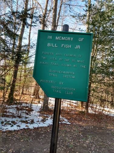
At the Bureau of Forestry Headquarters on US Route 6, near to the trailhead of the White Line Trail (Orange STS Blazes) that connects to STS hiking trail, hikers can find a memorial plaque in honor to the Founder of the STS, Bill Fish Jr.
The STS is an 85-mile loop hiking trail in Potter County in north-central Pennsylvania in the Susquehannock State Forest. This much longer circuit hike originates from the same parking area at the " STS Northern Gateway as this short loop hike.
WarningTimber Rattlesnakes: While there may not be an active rattlesnake den nearby, between the months of April and October, they may be out roaming the woods or drinking and hunting by the creeks. This trail does pass through some sun-lit meadows, which means chances of seeing a rattlesnake on this hike is possible but probably slim.