Loading...

WINTER SALE! 50% OFF Supporter Accounts — now through January 31st. Learn More.

Hightop Mountain Hike

The Hightop Mountain summit out/back hike has a beautiful panoramic vista, and is also one of the lesser known summit hikes in the Shenandoah National Park. The Swift Run Gap hike start area was was crossed by Virginia Lieutenant Governor Alexander Spotswood leading the Knights of the Golden Horseshoe expedition on September 5, 1716 as they passed into the Shenandoah Valley for the first time. Monuments to this crossing are erected on the southern side of VA33 at Swift Run Gap.

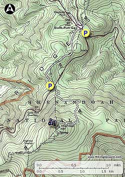
The main out and back hike from Swift Run Gap is 5.6 miles and 1,480ft of elevation gain. You can also shorten the hike by starting at the Hightop Mountain parking area on Skyline drive. This reduces the hike to 2.3 miles and 940ft of elevation gain.

  • Mile 0.0 - Start the hike from the southern end of the bridge that crosses VA33 on Skyline Drive. Cross Skyline Drive then start south uphill on the Appalachian Trail (AT). Shortly pass a stream on your right as the trail gradually passes over the first rise. The AT will then level out before passing over another rise, then descending to Skyline Drive and the Hightop Mountain parking area.
  • Mile 1.3 - Cross over Skyline Drive and and continue on the AT as the trail now more steeply ascends Hightop Mountain. Pass a section of large granite boulders, then as the trail nears the summit make several switchbacks.
  • Mile 2.75 - Arrive at the first of of the two vistas. The first vista is a more obscured view to the western Shenandoah Valley.
  • Mile 2.8 - Arrive at the main vista. There is a short trail that leads out to commanding views to the south and west. This is the turn around point. Retrace your route back down the AT.
  • Mile 5.2 - Arrive back at the parking area on on Skyline Drive at Swift Run Gap.
Explore 69 trails near Stanardsville, VA

Know Before You Go

  • Hightop Mountain offers a scenic, lesser-known summit hike with panoramic views in Shenandoah National Park.
  • The main trail from Swift Run Gap is 5.6 miles with a 1,480ft elevation gain, while a shorter 2.3-mile option starts from the Hightop Mountain parking area.
  • The trail follows the Appalachian Trail, crossing Skyline Drive and featuring historical significance related to the Knights of the Golden Horseshoe expedition.
Interactive topographic map for Hightop Mountain Hike located in Stanardsville, VA. Click the "View Map" button to load GPS coordinates and trail markers.
Get directions
Distance
5.2 mi
Difficulty
Moderate
Type
Out-and-Back
Est. Time
2.6 hrs
Elev. Gain
1,471'
Rating
3.7
Added
March 18, 2025
Updated
April 05, 2025

Weather Forecast

Tonight
Low 17°F
Mostly Cloudy
Thursday
High 22°F
Sunny
Thursday Night
Low 15°F
Mostly Clear
Friday
High 30°F
Mostly Sunny
Friday Night
Low 26°F
Partly Cloudy
Saturday
High 37°F
Chance Snow Showers
Saturday Night
Low 20°F
Chance Snow Showers then Slight Chance Light Snow
Sunday
High 23°F
Slight Chance Light Snow
Sunday Night
Low 12°F
Mostly Clear
M.L. King Jr. Day
High 27°F
Sunny
Monday Night
Low 10°F
Mostly Clear
Tuesday
High 21°F
Sunny
Tuesday Night
Low 10°F
Mostly Clear
Wednesday
High 30°F
Sunny
Loading...
Total Change
1,170'
Ascent
1,471'
Descent
1,471'
Loading...

Download the GPX Data for Offline Use

Supporters get exclusive access to download trail routes to the MyHikes app for offline use. Stay prepared on your adventure, even without an internet connection! Become a Supporter today to unlock this feature and hike with confidence.

Download Hightop Mountain Hike GPX Data to the MyHikes Mobile App

Features

Vista / Lookout Point
Dogs
Mountain Summit
Appalachian Trail logo Appalachian Trail hike

Points of interest

  1. Parking

    38.356116, -78.544934
  2. Main Trailhead

    38.356116, -78.544934

Safety information

For your own safety: plan ahead, let someone know where you'll be, and hike at your own risk.

Hazards

Snakes (Rattlesnakes, Copperheads, others)
Poison Ivy or Poison Oak

Markers

Blaze Color

White

Availability

All seasons

Surface type

Dirt

Trip Reports (Reviews)

Rated 3.67 out of 5 based on 9 ratings.

Ready to help fellow hikers? Add a trip report to share your experience and provide valuable insights for other hikers!

By: Tom R
5.2 miles / 8.4 km
June 03, 2017
Nice hike. We did as described. Wonderful view @ the summit. My main reason for writing is that we had wonderful coincidental interactions with so many individual (or in pairs) Northbound (NOBO) AT thru-hikers from all over the country.. We started @ the trailhead @ 7:55 AM, and began meeting them since most had broken camp earlier that morning at Hightop Hut. They were about 900 miles into their trek.
Legacy Review
By: Kate
5.2 miles / 8.4 km
May 20, 2017
Spring foliage was beautiful. Great camping area if you take the trail to the left @ summit marker.
Legacy Review
By: Fergus & Henri
5.2 miles / 8.4 km
January 28, 2017
We had beautiful sunny weather for this Saturday hike. Did the 5.6 mile version. Our overall assessment is that this is a great short-to-moderate length day hike with a TON of visual payoff at the top (especially during winter when leaves are off trees) for very little work. If you’re looking to introduce friends to hiking, this would be a great starter trail! Read more about our hike & see lots of photos here: https://fergusandhenri.com/2017/01/30/hightop-mountain/
Legacy Review
No community routes found. To add your own hike as a Community Route for this Trail guide, leave a Trip Report with an attached GPX file.

Popular categories

Scenic mountain view representing vista trails
Vista trails
Scenic gorge of cascades representing waterfall trails
Waterfall hikes
Rugged mountain terrain representing summit trails
Summit trails
Scenic mountain view representing dog-friendly trails
Dog-friendly
Scenic campsite with a view representing camping trails
Camping trails
Appalachian Trail logo representing A.T. hikes
A.T. hikes

You May Also Like

25 Best Day Hikes in North Carolina - Discover the top 25 best day hikes in North Carolina, from breathtaking waterfalls to mountain peaks. Explore hidden gems, scenic views, and trails suitable for all skill levels, perfect for your next outdoor adventure.
Explore

25 Best Day Hikes in North Carolina

Discover the top 25 best day hikes in North Carolina, from breathtaking waterfalls to mountain peaks. Explore hidden gems, scenic views, and trails suitable for all skill levels, perfect for your next outdoor adventure.

Read
🍪 We use cookies to learn about site usage and to serve map tiles. You may block cookies manually in the browser. By continuing you agree. Learn more