Loading...

WINTER SALE! 50% OFF Supporter Accounts — now through January 31st. Learn More.

High Knob & Brandywine Recreation Area Hike

The Brandywine Recreation Area, on the border of Virginia and West Virginia, has two totally different hikes within its borders. The strenuous High Knob hike up to a spectacular 360° view at the fire tower, and the Saw Mill loop which is an easy 3.7 mile walk along two of the areas creeks.

The Brandywine Recreation area is a perfect spot to go for the weekend. With a man made beach on Brandywine Lake plus 32 campsites, clean bathrooms and hot showers, and potable water throughout the camping area. Also, if you come with a large group there is a group/overflow camping spot with picnic tables and fire rings at the back of the main camping facilities. Please Note: Both hikes are rated for camping because of the camping facilities at the Brandywine Recreation Area, not for campsites on the trails.

Note: The High Knob Tower can also be hiked directly from US33 as an easy 2.9 mile/600ft gain.
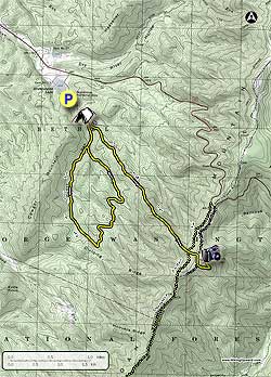
High Knob Tower:
This hike is rated strenuous because of the steep grade of the trail. The trail does not make any switchbacks on its 2.9 mile climb to the fire tower.

The High Knob trail starts at the right front of the Group Campground. Start up the yellow blazed High Knob trail as it steeply climbs for the first 0.2 miles before becoming an easier grade along the ridge. The trail will again become very steep for the last 0.5 miles then reach the intersection of the Shenandoah Mountain Trail.

At the intersection of the Shenandoah Mountain Trail continue straight on the High Knob Trail for another 0.2 miles where the yellow blazed High Knob trail turns right and follows a fire road for 0.1 miles. The trail then leaves the fire road and turning left uphill. In 200 yards the trail will join another fire road for the remaining 0.2 miles to the ridge and fire tower.

Climb to the lookout platform on the fire tower for a spectacular 360° panorama into Virginia and West Virginia. To return retrace your route.

Saw Mill Loop:
The Saw Loop is an easy walk in the woods compared to the hard climb up to High Knob. There are several open wildlife clearings as well as two seasonal creeks.

From the back loop of the campground follow the yellow blazed Saw Mill Loop trail for 0.3 miles to the beginning of the loop portion of the hike. From here turn right and follow the loop 3.1 miles back to the same point. On the first part of the loop Hawes Creek is on your left, then cross a small ridge on the back side of the loop and follow a feeder stream back to the beginning of the loop before turning right for the 0.3 miles back to the hike start point.

Explore 52 trails near Brandywine, WV

Know Before You Go

  • The Brandywine Recreation Area offers diverse hiking experiences, from the challenging High Knob trail with panoramic views to the easier Saw Mill Loop along creeks.
  • High Knob trail is strenuous due to its steep, direct ascent to the fire tower, while an easier, shorter route to the tower is available from US33.
  • The area provides comprehensive camping facilities, including campsites, clean amenities, and potable water, making it suitable for weekend getaways.
Interactive topographic map for High Knob & Brandywine Recreation Area Hike located in Brandywine, WV. Click the "View Map" button to load GPS coordinates and trail markers.
Get directions
Distance
10.1 mi
Difficulty
Strenuous
Type
Out-and-Back
Est. Time
5.1 hrs
Elev. Gain
2,892'
Rating
3.7
Added
January 24, 2025
Updated
April 04, 2025

Weather Forecast

Loading...
Total Change
2,200'
Ascent
2,892'
Descent
2,879'
Loading...

Download the GPX Data for Offline Use

Supporters get exclusive access to download trail routes to the MyHikes app for offline use. Stay prepared on your adventure, even without an internet connection! Become a Supporter today to unlock this feature and hike with confidence.

Download High Knob & Brandywine Recreation Area Hike GPX Data to the MyHikes Mobile App

Features

Vista / Lookout Point
Dogs
Mountain Summit
Camping

Points of interest

  1. Parking

    38.598838, -79.201232
  2. Main Trailhead

    38.598426, -79.20104

Safety information

For your own safety: plan ahead, let someone know where you'll be, and hike at your own risk.

Hazards

Snakes (Rattlesnakes, Copperheads, others)
Poison Ivy or Poison Oak

Availability

All seasons

Surface type

Dirt

Trip Reports (Reviews)

Rated 3.65 out of 5 based on 17 ratings.

Ready to help fellow hikers? Add a trip report to share your experience and provide valuable insights for other hikers!

By: Peter
10.1 miles / 16.3 km
October 13, 2018
I haven't hiked this hike since my review in 2010, when I had the negative bear encounter. I went with a friend, and it was great. The hike was much easier than it used to be for me, and I wasn'y even slightly sore at the end. The views are as I remember them, amazing, however, there were more people at the fire tower than when I was younger, with 6 showing up after we got there and 8 more going up, all from the parking lot trail on 33. When I was younger, I never saw anyone at the fire tower. I used to be able to go inside, but you no longer can, they have boarded up the door. But, that aside it is a wonderful hike, and is still one of the hardest ones I know in the region.
Legacy Review
By: Dick
10.1 miles / 16.3 km
March 31, 2018
I first hiked High Knob on August 4th 2017. I had plans on hiking Down Pikes Peak on September the 2nd with my son and I felt I should get some practice in before attempting to hike 13.5 miles down from the 14,115 foot summit. I hiked several other trails before I found High Knob and none of them can compare to High Knob for difficulty, (no switchbacks and straight up) it was perfect for my training purpose. I truly believe that to hike up and down High Knob is just as difficult if not more difficult than our hiking Down the 13.5 miles of Pikes Peak. The BIG difference was the elevation issue. You do need to make sure you’re ready to hike at that extreme elevation (14,115 ft.) for the 8.5 hour hike. For here in the Shenandoah Valley, for strenuous, solitude and views, I don’t think you can beat the hike from the Brandywine Recreation Area to the top of the Shenandoah Mountain on the High Knob trail. I enjoyed this hike so much that since August 4th, 2017 thru December 31st (5 months) I hiked this trail twenty-seven times. (Some would say that's crazy and they may be right). Anyway, with the weather warming, looks like it’s time to hit that trail again. :)
Legacy Review
By: Ed & Jackie
10.1 miles / 16.3 km
June 11, 2017
Hiked the Sawmill Loop Trail, starting early (9:30am) in order to beat the heat forecast for the day. The trail doesn't appear to get a lot of use, and there are many trees down that you need to climb over or walk around. There are several grassy areas that are overgrown with tall vegetation and it was pure guesswork as to where to go as the trail completely disappeared. Overall, though, this was an enjoyable hike, with pretty, open woods. There are several small stream crossings, but water was very low and they did not present a challenge. Over half the hike is uphill, but never very steep. Very quiet, we had had the trail to ourselves. We give it 3.5 stars...
Legacy Review
No community routes found. To add your own hike as a Community Route for this Trail guide, leave a Trip Report with an attached GPX file.

Popular categories

Scenic mountain view representing vista trails
Vista trails
Scenic gorge of cascades representing waterfall trails
Waterfall hikes
Rugged mountain terrain representing summit trails
Summit trails
Scenic mountain view representing dog-friendly trails
Dog-friendly
Scenic campsite with a view representing camping trails
Camping trails
Appalachian Trail logo representing A.T. hikes
A.T. hikes

You May Also Like

Colorado's Million Dollar Highway - Plan a day's drive adventure along the iconic Million Dollar Highway in Colorado. Explore the best short trails, roadside stops, waterfalls, vistas, ghost towns, and hot springs within a ~6 hour road trip.
Explore

Colorado's Million Dollar Highway

Plan a day's drive adventure along the iconic Million Dollar Highway in Colorado. Explore the best short trails, roadside stops, waterfalls, vistas, ghost towns, and hot springs within a ~6 hour road trip.

Read
🍪 We use cookies to learn about site usage and to serve map tiles. You may block cookies manually in the browser. By continuing you agree. Learn more