Loading...

🎆 50% off 4th of July sale on Supporter Accounts — now through July 6! Learn More.

High Knob Tower Hike

Directions
Map
Pictures
Send to App
Distance:
2.6 Miles / 4.2 km
Type:
Out-and-Back
Difficulty:
Easy
Time to Hike:
1 hour, ~18 minutes
Features:
Surface Type:
Dirt
Park:
George Washington National Forest
Town:
Brandywine, West Virginia
Directions:
38.5796, -79.169117
Added:
January 27, 2025
Updated:
April 04, 2025
Copy Trail Link Hiking this trail? Send a friend or family member a link to this trail guide for your own safety. Hike at your own risk (disclaimer)
Loading...
Loading...
677'

Total Change
756'

Ascent
757'

Descent

Download the Trail Route for Offline Use

Supporters get exclusive access to download trail routes to the MyHikes app for offline use. Stay prepared on your adventure, even without an internet connection! Become a Supporter today to unlock this feature and hike with confidence.

Send to App

High Knob Tower Hike

The High Knob Fire Tower is located on Shenandoah Mountain west of Harrisonburg, and sits on the boundary line between Virginia and West Virginia. The tower is an historic structure renovated in 2003 which also enhanced trail access from a new parking area just west of the ridgeline, on the West Virginia side of the mountain. Note that the parking area is not on the top of the mountain – that is private property.

Workers for the Civilian Conservation Corps and World War I veterans constructed the tower during 1939-40 using rocks from Shenandoah Mountain. It is now the only stone fire tower in Virginia and is the only intact tower of this type on national forest lands east of the Mississippi River. Most fire towers were constructed of metal. You can find a more complete history of this historic structure on the Friends of Shenandoah Mountain website. The Friends of Shenandoah Mountain is an organization committed to preserving much of the High Knob Fire Tower’s views, including proposed wilderness designation for over 5200 acres in the slope and valley just east of the tower.

This hike presents a much easier access to the structure and its fabulous 360 degree views than the trail from the Brandywine Campground, and is suitable for families with younger hikers. Despite its short length, however, there are some briefly steep sections and some of the trail is rocky, especially right next to the parking lot!

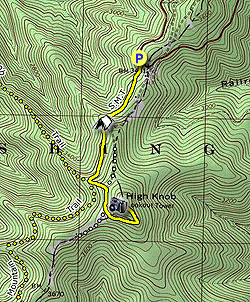
  • Mile 0.0 – The route starts on the Shenandoah Mountain Trail, a yellow blazed trail that starts behind a hiker sign on the eastern end of the parking area, furthest away from the lot entrance. The trail drops steeply from the parking area on large rocks, before leveling out on a dirt path. This section of the trail is also a portion of the Great Eastern Trail, a long distance trail under development running west of the Appalachian Trail from New York to Alabama.

  • Mile 0.5 – A small, dry campsite with fire ring is on the left side of the trail. An unmarked trail also descends on the right, but it peters out after about 15 feet. Continue generally south along the side of the slope of Shenandoah Mountain.

  • Mile 0.8 – The trail intersects with the High Knob Trail, which drops steeply over 3 miles to the forest service’s Brandywine Campground. The Shenandoah Mountain Trail and the Great Eastern Trail continue south here for five miles over the ridge of Shenandoah Mountain to a rough road that leads further south to Reddish Knob. The trail to the fire tower takes a sharp left and climbs quickly. Take the steep uphill option.

  • Mile 0.9 – Trail meets a woods road and turns right on the road. Taking a left on this road enters private property. Turn right. Please respect private property.

  • Mile 1.0 – Shortly before the road leaves the woods for an open area the trail cuts left, leaving the woods road.

  • Mile 1.1 – The trail merges onto another woods road, which it follows to the summit and the fire tower. Make sure to take the trail you just hiked on the way back to your car, to avoid entering private property.

  • Mile 1.4 – The road ascends to an open area with the fire tower and a sign describing the tower. Hikers can ascend the stairs on the fire tower to a viewing platform for a spectacular view into two states, extending west as far as Spruce Knob, the highest point in West Virginia, and east to the Blue Ridge Mountains and Shenandoah National Park. Return by retracing your route back to the hiker parking lot.
By HikingUpward contributor: Jeff Monroe
Explore 48 trails near Brandywine, WV
  1. Parking

    38.5796, -79.169117
  2. Main Trailhead

    38.5796, -79.169117
No community routes found. To add your own hike as a Community Route for this Trail guide, leave a Trip Report with an attached GPX file.

Hazards

Ticks - Lyme Disease More Info (CDC)
Snakes
Poison Ivy/Oak

Seasons

All

Blaze Color

Yellow

Trip Reports

Trail Guide By:
HikingUpward user profile picture
2.6 miles / 4.2 km

Weather Forecast

In Brandywine, WV

Explore Hiking Trails

You May Also Like

Colorado's Million Dollar Highway - Plan a day's drive adventure along the iconic Million Dollar Highway in Colorado. Explore the best short trails, roadside stops, waterfalls, vistas, ghost towns, and hot springs within a ~6 hour road trip.
Explore

Colorado's Million Dollar Highway

Plan a day's drive adventure along the iconic Million Dollar Highway in Colorado. Explore the best short trails, roadside stops, waterfalls, vistas, ghost towns, and hot springs within a ~6 hour road trip.

Read
New York's Best Waterfalls - Whether you're planning a day hike, roadside stop, or a leisurely short walk, this guide provides hikers, travelers, and locals alike with 63 different locations to over 100 scenic waterfalls to help plan your next adventure!
Explore

New York's Best Waterfalls

Whether you're planning a day hike, roadside stop, or a leisurely short walk, this guide provides hikers, travelers, and locals alike with 63 different locations to over 100 scenic waterfalls to help plan your next adventure!

Read

Before you boogie...

Find our trail guides useful? Consider becoming a Supporter to unlock perks!

MyHikes is an indie platform that makes exploring public trails easier for everyone. The platform has no investors, no ads, and is owned and operated by one person, Dave Miller. Dave has personally mapped and written over 1,800 trail guides on MyHikes for the public to explore. MyHikes has helped millions outdoor enthusiasts plan their next adventure.

But it takes a lot of time 🕦, money 💰, work, and espresso shots ☕ to run MyHikes, including hiking , mapping , writing , and publishing new trails with high-quality (accurate) information... along with software engineering (coding) the platform like building new features, website and mobile app development (iOS and Android), site maintainance . and much much more.

Supporters unlock website and mobile app perks with an annual one-time payment of $25 (you renew) 😎👍. Or you can simply make a Donation of your choice. Otherwise, you can support us by telling your friends about MyHikes - both quick and free 🎉

Admin user profile picture

Dave Miller
MyHikes Founder