Loading...

❄️ WINTER SALE! 50% OFF on Supporter Accounts — now through January 31st. Unlock a full year of exclusive website & app perks. Learn More.

High Bridge Hike

From the State Park website: “High Bridge Trail is 31 miles long and ideally suited for hiking, bicycling and horseback riding. Once a rail bed, the trail is wide, level and generally flat. Its finely crushed limestone surface and dimensions make it easy to enjoy. The park’s centerpiece is the majestic High Bridge, which is more than 2,400 feet long and 125 feet above the Appomattox River.

High Bridge is the longest recreational bridge in Virginia, and among the longest in the United States. High Bridge, a Virginia Historic Landmark, is on the National Register of Historic Places. The trail is a National Recreation Trail recognizing exemplary trails of local and regional significance, connecting people to nature, to each other, and to our shared history and culture. Bring drinking water because none is available on the trail.”

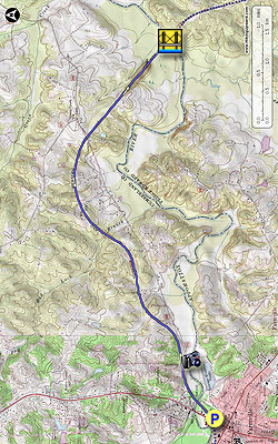
We hiked the Farmville to High Bridge section of the trail as an out and back. There is plenty of on street parking and other public parking close to the start of the trail. This trail is a very flat trail with no noticeable elevation change. The surface of the trail is packed hard so wear comfortable shoes. I normally take hiking poles but did not use them on this hike. The trail is exposed in many areas so wear a hat. The trail passes through wooded areas and pastures on the way to High Bridge. You will most likely run into more bikers than hikers.

  • Mile 0.0 – The trail begins at the intersection of Main and Depot Streets and heads east towards the Appomattox River.
  • Mile 0.3 – Reach the Appomattox River, cross over the bridge which also crosses Route 600.
  • Mile 0.6 – Osborne Road
  • Mile 1.6 – Burke Road
  • Mile 3.5 – River Road Parking area, fee required. This is an alternative parking area if you just want to see High Bridge or don't have enough time to hike the out and back. From River Road to High Bridge is about 1 mile.
  • Mile 4.5 – Beginning of High Bridge. View the amazing bridge as you make your way to just past the middle to where it crosses the Appomattox River, be sure to look for some of the original brick pilings.
  • Mile 4.9 – Appomattox River Overlook. Enjoy the views and then retrace your steps to Farmville or the River Road Parking Area.
  • Mile 9.7 - Arrive back at the parking area.
By HikingUpward Contributor: Bryce Allison
Explore 1 trail near Farmville, VA

Know Before You Go

  • The High Bridge Trail near Farmville, VA, offers a flat and accessible 9.7-mile out-and-back hike (Farmville to High Bridge section), suitable for various activities like hiking, biking, and horseback riding.
  • The highlight of the hike is High Bridge, a significant landmark with historical importance, offering impressive views of the Appomattox River 125 feet below.
  • Key considerations include bringing water due to its unavailability on the trail, wearing comfortable shoes, and being prepared for sun exposure due to limited shade.
Interactive topographic map for High Bridge Hike located in Farmville, VA. Click the "View Map" button to load GPS coordinates and trail markers.
Get directions
Distance
9.7 mi
Difficulty
Hard
Type
Out-and-Back
Est. Time
4.9 hrs
Elev. Gain
432'
Rating
2.5
Added
April 03, 2025
Updated
April 06, 2025

Weather Forecast

Loading...
Total Change
110'
Ascent
432'
Descent
432'
Loading...

Download the GPX Data for Offline Use

Supporters get exclusive access to download trail routes to the MyHikes app for offline use. Stay prepared on your adventure, even without an internet connection! Become a Supporter today to unlock this feature and hike with confidence.

Download High Bridge Hike GPX Data to the MyHikes Mobile App

Features

Vista / Lookout Point
Dogs
Biking

Points of interest

  1. Parking

    37.304413, -78.391104
  2. Main Trailhead

    37.304413, -78.391104

Safety information

For your own safety: plan ahead, let someone know where you'll be, and hike at your own risk.

Availability

All seasons

Surface type

Dirt

Trip Reports (Reviews)

Rated 2.5 out of 5 based on 2 ratings.

Ready to help fellow hikers? Add a trip report to share your experience and provide valuable insights for other hikers!

By: PQK
9.7 miles / 15.6 km
September 04, 2016
We actually rode our bikes on the High Bridge Trail. The bridge itself is the only real high point, but it was good exercise!
Legacy Review
By: Rick & Martha
9.7 miles / 15.6 km
December 12, 2015
We enjoyed the hike as more of a nice, loooong nature walk than our typical hike over hilly terrain. It being in the 70s was a plus. Because it is so flat and straight-ish, with not too much in the way of views until you get to the spectacular bridge, we found it a bit boring, but still worth it. The next time we're in the Farmville area, however, I would like to go across the bridge again, but I'd park in the River Road lot. (Cautionary note: In winter, you don't want to be lured into Charley's Restaurant in Farmville for lunch before you set out, because it was dark by the time we got back!)
Legacy Review
No community routes found. To add your own hike as a Community Route for this Trail guide, leave a Trip Report with an attached GPX file.

Popular categories

Scenic mountain view representing vista trails
Vista trails
Scenic gorge of cascades representing waterfall trails
Waterfall hikes
Rugged mountain terrain representing summit trails
Summit trails
Scenic mountain view representing dog-friendly trails
Dog-friendly
Scenic campsite with a view representing camping trails
Camping trails
Appalachian Trail logo representing A.T. hikes
A.T. hikes

You May Also Like

25 Best Day Hikes in North Carolina - Discover the top 25 best day hikes in North Carolina, from breathtaking waterfalls to mountain peaks. Explore hidden gems, scenic views, and trails suitable for all skill levels, perfect for your next outdoor adventure.
Explore

25 Best Day Hikes in North Carolina

Discover the top 25 best day hikes in North Carolina, from breathtaking waterfalls to mountain peaks. Explore hidden gems, scenic views, and trails suitable for all skill levels, perfect for your next outdoor adventure.

Read
🍪 We use cookies to learn about site usage and to serve map tiles. You may block cookies manually in the browser. By continuing you agree. Learn more