Loading...

🎉 Enjoy a Free 7-Day Supporter Trial and Unlock Exclusive Perks — No Credit Card Required. Learn more.

Hidden Valley Hike

Directions
Map
Pictures
Send to App
Distance:
5.2 Miles / 8.4 km
Type:
Loop
Difficulty:
Easy
Time to Hike:
2 hours, ~36 minutes
Features:
Surface Type:
Dirt
Park:
George Washington National Forest
Town:
Chimney Run, Virginia
Directions:
38.094005, -79.816217
Added:
January 27, 2025
Updated:
April 04, 2025
Copy Trail Link Hiking this trail? Send a friend or family member a link to this trail guide for your own safety. Hike at your own risk (disclaimer)
Loading...
Loading...
228'

Total Change
429'

Ascent
429'

Descent

Download the Trail Route for Offline Use

Supporters get exclusive access to download trail routes to the MyHikes app for offline use. Stay prepared on your adventure, even without an internet connection! Become a Supporter today to unlock this feature and hike with confidence.

Send to App

Hidden Valley Hike

Hidden Valley in Bath County VA is one more hidden gem in the crown of mid-Atlantic hiking. There are many interconnecting trails in the valley itself, as well as a campground at the Forest Service Hidden Valley Recreation Area. The post-Civil War love story Sommersby was also filmed at Hidden Valley with Richard Gere and Jodi Foster in 1993. Once a year we'll hike this area and spend the weekend in our favorite B&B Gristmill Square just a few miles away. The food and staff are fantastic.

The Topo Hike Trails Map has green, yellow, and red trails that are no longer maintained and now pass through private property. They are listed for reference only and are no longer part of the trail system.

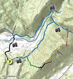
Start out on the blue blazed Cobbler Mountain Trail as it ascends then descends the spur before arriving at a wooden footbridge that crosses Chimney Run in 0.7 miles. Cross the run and continue left on the blue blazed trail as it follows Chimney Run downstream. The trail to the right dead-ends on private property within 0.2 miles.

Follow the blue blazed Cobbler Mountain Trail for 2.0 miles as it winds along the bottom of Cobbler Mountain with Chimney Run to the left before passing through a wetland area and descending to the intersection of the blue blazed Muddy Run Trail. Turn left on the Muddy Run Trail for 0.1 miles where the trail ends at the Hidden Valley Trail and where a small wooded footbridge crosses Muddy Run.

At this point you can take one of two trails back downstream on either side of the Jackson River. For the Jackson River Gorge Trail on the opposite back of Jackson river cross Muddy Run on the footbridge and in another 0.2 miles arrive at a large suspension bridge that crosses Jackson River.

Cross Jackson River on the suspension bridge and turn left on the Jackson River Gorge Trail as it follows Jackson River downstream and arrives at a closed gate in 1.8 miles. Pass the closed gate and turn left on the gravel road and shortly cross Jackson River over a concrete ford. Continue to follow Hidden Valley Road for 1.2 miles. The road will become paved then pass the Hidden Valley GWNF campground on your right before you arrive back at the Cobbler Mountain Trail parking area.

Explore 33 trails near Chimney Run, VA
  1. Parking

    38.094005, -79.816217
  2. Main Trailhead

    38.093784, -79.816017
No community routes found. To add your own hike as a Community Route for this Trail guide, leave a Trip Report with an attached GPX file.

Hazards

Ticks - Lyme Disease More Info (CDC)
Snakes
Poison Ivy/Oak

Seasons

All

Trip Reports

Trail Guide By:
HikingUpward user profile picture
5.2 miles / 8.4 km

Weather Forecast

In Chimney Run, VA

Explore Hiking Trails

You May Also Like

New York's Best Waterfalls - Whether you're planning a day hike, roadside stop, or a leisurely short walk, this guide provides hikers, travelers, and locals alike with 63 different locations to over 100 scenic waterfalls to help plan your next adventure!
Explore

New York's Best Waterfalls

Whether you're planning a day hike, roadside stop, or a leisurely short walk, this guide provides hikers, travelers, and locals alike with 63 different locations to over 100 scenic waterfalls to help plan your next adventure!

Read
25 Best Day Hikes in North Carolina - Discover the top 25 best day hikes in North Carolina, from breathtaking waterfalls to mountain peaks. Explore hidden gems, scenic views, and trails suitable for all skill levels, perfect for your next outdoor adventure.
Explore

25 Best Day Hikes in North Carolina

Discover the top 25 best day hikes in North Carolina, from breathtaking waterfalls to mountain peaks. Explore hidden gems, scenic views, and trails suitable for all skill levels, perfect for your next outdoor adventure.

Read

Before you boogie...

Find our trail guides useful? Consider becoming a Supporter to unlock perks!

MyHikes is an indie platform that makes exploring public trails easier for everyone. The platform has no investors, no ads, and is owned and operated by one person, Dave Miller. Dave has personally mapped and written over 1,800 trail guides on MyHikes for the public to explore. MyHikes has helped millions outdoor enthusiasts plan their next adventure.

But it takes a lot of time 🕦, money 💰, work, and espresso shots ☕ to run MyHikes, including hiking , mapping , writing , and publishing new trails with high-quality (accurate) information... along with software engineering (coding) the platform like building new features, website and mobile app development (iOS and Android), site maintainance . and much much more.

Supporters unlock website and mobile app perks with an annual one-time payment of $25 (you renew) 😎👍. Or you can simply make a Donation of your choice. Otherwise, you can support us by telling your friends about MyHikes - both quick and free 🎉

Admin user profile picture

Dave Miller
MyHikes Founder