Loading...

❄️ WINTER SALE! 50% OFF on Supporter Accounts — now through January 31st. Unlock a full year of exclusive website & app perks. Learn More.

Hidden Rocks Hike

Hone Quarry, just west of Harrisonburg Virginia, is one of the least utilized trail systems in the George Washington National Forest. Hidden Rocks is the shortest of the three main hikes in this area, along with Oak Knob and Hone Quarry Ridge. At only 2.5 miles in length the hike passes over Rocky Run with a small pool and waterfall, starts up Back Mountain to Hidden Rocks which is favorite of local climbers, and continues on the small loop trail past Hidden Cracks, and returns down the run.
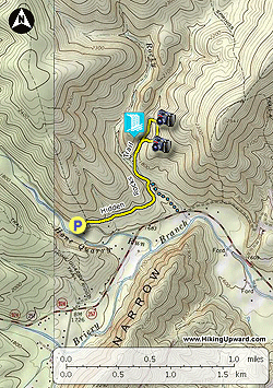
  • Mile 0.0 - The yellow blazed Hidden Rocks Trail starts at the right side of the parking area. The trail will pass through three gullies then descends to Rocky Run where you enter a dense area of rhododendron.

  • Mile 0.65 - Cross Rocky Run and reach the intersection of the blue trail on the right, and the yellow blazed Hidden Run Trail stays left. Continue to follow the yellow blazed trail upstream and cross Rocky Run two more times then reach a split in the trail.

  • Mile 0.9 - Turn right steeply uphill and in 100 yards arrive at the bottom of the Hidden Rocks wall. Follow the trail to the left as it climbs around the wall. Near the high point look for a set of wooden stairs on the right. Climb the stairs to the top of Hidden Rocks where there is a campsite and views across the valley of Hone Quarry.

  • Mile 1.1 - Head back down the steps and stay right continuing on the loop section of the Hidden Rocks Trail. Shortly arrive at Hidden Cracks with another large granite wall. Halfway along the wall look for a gully that you can steeply climb and follow it on the left side. At the top there is a nice view back down the valley. Climb back down to the trail and stay right where the trail descends towards the stream.

  • Mile 1.4 - Cross the tributary of Rocky Run and follow the trail downstream.

  • Mile 1.6 - Arrive at the waterfall and pool with the trail loop intersection you passed earlier on the opposite site of the run. Continue downstream on the Hidden Rocks Trail retracing your steps the remaining 0.9 miles back to the parking area.

  • Mile 2.3 - Arrive back at the parking area on Hone Quarry Road.
Explore 48 trails near Dayton, VA

Know Before You Go

  • Hidden Rocks Trail is a 2.3-mile loop hike in the Hone Quarry area near Harrisonburg, VA.
  • The trail features stream crossings at Rocky Run, a waterfall, rock formations (Hidden Rocks and Hidden Cracks), and a viewpoint.
  • The hike includes steep ascents and descents, with some optional scrambling at Hidden Cracks.
Interactive topographic map for Hidden Rocks Hike located in Dayton, VA. Click the "View Map" button to load GPS coordinates and trail markers.
Get directions
Distance
2.3 mi
Difficulty
Easy
Type
Out-and-Back
Est. Time
1.2 hrs
Elev. Gain
425'
Rating
4.0
Added
January 27, 2025
Updated
May 26, 2025

Weather Forecast

Loading...
Total Change
292'
Ascent
425'
Descent
428'
Loading...

Download the GPX Data for Offline Use

Supporters get exclusive access to download trail routes to the MyHikes app for offline use. Stay prepared on your adventure, even without an internet connection! Become a Supporter today to unlock this feature and hike with confidence.

Download Hidden Rocks Hike GPX Data to the MyHikes Mobile App

Features

Vista / Lookout Point
Dogs
Waterfalls
Camping

Points of interest

  1. Parking

    38.448134, -79.12205
  2. Main Trailhead

    38.448134, -79.12205

Safety information

For your own safety: plan ahead, let someone know where you'll be, and hike at your own risk.

Hazards

Snakes (Rattlesnakes, Copperheads, others)
Poison Ivy or Poison Oak
Rockfalls, Ledges, or Scrambles

Markers

Blaze Color

Yellow

Availability

All seasons

Surface type

Dirt

Trip Reports (Reviews)

Rated 4.0 out of 5 based on 6 ratings.

Ready to help fellow hikers? Add a trip report to share your experience and provide valuable insights for other hikers!

By: Rose
2.3 miles / 3.7 km
April 17, 2019
Nice hike however Rocky Run had high water and was difficult to cross. Plan on aqueous footwear if possible. There are rocks to walk across on and keep out of the water in some places but many were loose and wobbled quite a bit. After the initial crossing of Rocky Run the trail makes a sharp left and travels directly upstream of Rocky Run which had completely overrun the trail for about 20 yds, Spotted lots of yellow violets and some bluets. Awesome views from the top of Hidden Rocks!
Legacy Review
By: Steffen
2.3 miles / 3.7 km
August 18, 2018
The hike was beautiful and fun exactly as described, but as far as solitude I would give it one star. While camping at the overlook we were visited by a boy scout troop, four hikers, and three other campers who came to camp at the same look out. We could also hear cars from the road on the overlook. We left shortly afterwards. Overall I would say it's a wonderful day hike that seems to have been discovered, but don't go to camp. A quick picnic is a better option.
Legacy Review
No community routes found. To add your own hike as a Community Route for this Trail guide, leave a Trip Report with an attached GPX file.

Popular categories

Scenic mountain view representing vista trails
Vista trails
Scenic gorge of cascades representing waterfall trails
Waterfall hikes
Rugged mountain terrain representing summit trails
Summit trails
Scenic mountain view representing dog-friendly trails
Dog-friendly
Scenic campsite with a view representing camping trails
Camping trails
Appalachian Trail logo representing A.T. hikes
A.T. hikes

You May Also Like

25 Best Day Hikes in North Carolina - Discover the top 25 best day hikes in North Carolina, from breathtaking waterfalls to mountain peaks. Explore hidden gems, scenic views, and trails suitable for all skill levels, perfect for your next outdoor adventure.
Explore

25 Best Day Hikes in North Carolina

Discover the top 25 best day hikes in North Carolina, from breathtaking waterfalls to mountain peaks. Explore hidden gems, scenic views, and trails suitable for all skill levels, perfect for your next outdoor adventure.

Read
🍪 We use cookies to learn about site usage and to serve map tiles. You may block cookies manually in the browser. By continuing you agree. Learn more