The Hidden Falls Trail at Wasatch National Forest near Salt Lake City, Utah is an easy 0.1-mile out-and-back hike that leads to the scenic 25-foot tall waterfall, Hidden Falls.
Hike
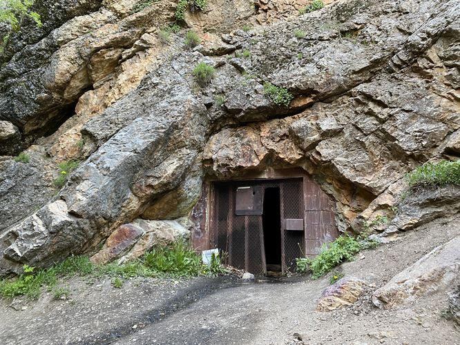
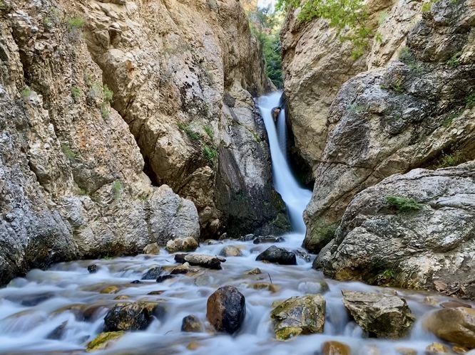
This very short hike begins at the main parking lot for Hidden Falls, located in between a switchback turn in UT-190. The trailhead can be found near the further end of this parking lot. The trail leads uphill immediately along a series of stairs, before it crosses UT-190 within Big Cottonwood Canyon. The trail then leads back into the woods before taking a left-hand turn at the signage. It then leads down toward the creek where it skirts along the eastern side of Mill B North Fork creek. During our hike here in late May 2024, the snow melt from the high elevation peaks caused the trail to flood slightly. This wasn't a problem, but we had to walk through a bit of water to continue along the steeper dirt path that lead up and out of the creek, skirting some steep terrain. The trail levels out a bit more as it leads up toward Hidden Falls. Eventually, you'll come up to Hidden Falls as it cascades down into the gorge ahead of you at about 25-feet tall. The trail abruptly ends, at least during period of heavy rain or snow melt, where you'll find a beautiful view of Hidden Falls from ~100-feet downstream. To the east, located up a small hill on-trail, is a metal-gated cave and/or old mine shaft. During our hike here, I didn't peer inside but assumed due to the old metal gate and mining history of these mountains, that it's likely mining-related (best to stay out). The trail then descends back to the parking lot to complete this very short 0.15-mile hike.
Parking
Hikers will find a parking lot at the coordinates provided, within Big Cottonwood Canyon along UT-190. The lot is large enough to fit over a dozen vehicles and is a popular day use area for folks, so the lot is generally full. We showed up in the evening on a Friday to find the lot was almost completely full, but we were the only hikers at Hidden Falls surprisingly.
Pets
Dogs are not allowed within Big Cottonwood Canyon.
Hike
This very short hike begins at the main parking lot for Hidden Falls, located in between a switchback turn in UT-190. The trailhead can be found near the further end of this parking lot. The trail leads uphill immediately along a series of stairs, before it crosses UT-190 within Big Cottonwood Canyon. The trail then leads back into the woods before taking a left-hand turn at the signage. It then leads down toward the creek where it skirts along the eastern side of Mill B North Fork creek. During our hike here in late May 2024, the snow melt from the high elevation peaks caused the trail to flood slightly. This wasn't a problem, but we had to walk through a bit of water to continue along the steeper dirt path that lead up and out of the creek, skirting some steep terrain. The trail levels out a bit more as it leads up toward Hidden Falls. Eventually, you'll come up to Hidden Falls as it cascades down into the gorge ahead of you at about 25-feet tall. The trail abruptly ends, at least during period of heavy rain or snow melt, where you'll find a beautiful view of Hidden Falls from ~100-feet downstream. To the east, located up a small hill on-trail, is a metal-gated cave and/or old mine shaft. During our hike here, I didn't peer inside but assumed due to the old metal gate and mining history of these mountains, that it's likely mining-related (best to stay out). The trail then descends back to the parking lot to complete this very short 0.15-mile hike.
Parking
Hikers will find a parking lot at the coordinates provided, within Big Cottonwood Canyon along UT-190. The lot is large enough to fit over a dozen vehicles and is a popular day use area for folks, so the lot is generally full. We showed up in the evening on a Friday to find the lot was almost completely full, but we were the only hikers at Hidden Falls surprisingly.
Pets
Dogs are not allowed within Big Cottonwood Canyon.