Loading...

๐ŸŽ‰ Enjoy a Free 7-Day Supporter Trial and Unlock Exclusive Perks โ€” No Credit Card Required. Learn more.

Hiawatha Forest Southern Trail

Directions
Map
Pictures
Send to App
Distance:
1.8 Miles / 2.9 km
Type:
Out-and-Back
Difficulty:
Easy
Time to Hike:
~54 minutes
Features:
Surface Type:
Dirt
Park:
Hiawatha Forest
Town:
Grand Haven, Michigan
Directions:
42.94294, -86.197547
Added:
January 15, 2020
Updated:
January 25, 2024
Copy Trail Link Hiking this trail? Send a friend or family member a link to this trail guide for your own safety. Hike at your own risk (disclaimer)
Loading...
Loading...
8'

Total Change
14'

Ascent
15'

Descent

Download the Trail Route for Offline Use

Supporters get exclusive access to download trail routes to the MyHikes app for offline use. Stay prepared on your adventure, even without an internet connection! Become a Supporter today to unlock this feature and hike with confidence.

Send to App

Hiawatha Forest Southern Trail

The Hiawatha Forest Southern Trail at Hiawatha Forest Open Space in Grand Haven, Michigan is an easy 1.8-mile out-and-back trail that features a beautiful pine forest, a tiny pond, and runs parallel with the Hiawatha Forest Main Trail.

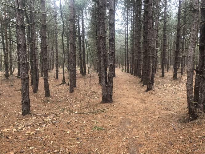
This short but easy hike leads out to the middle of the Eastern section of the Hiawatha Forest Open Space. Hikers will meander their way through the forest, heading north and taking a couple of turns before the trail heads west, out to a small pond.

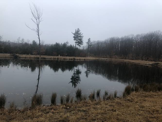
Once at the pond, hikers can take in the views before making their way back to parking. Alternatively, hikers can also connect to the Hiawatha Forest Main Trail from this trail as well; however, no trail junction is shown on the park map.

Amenities & Activities
  • Small parking areas and information kiosk
  • Off-trail hiking and cross-country skiing
  • Dogs are allowed on or off leash
  • Open to hunting per DNR Laws. More information
Hours
5am to 10pm

Parking
Hikers can find parking at the coordinates provided. The parking area is not plowed in winter, though local residents and hunters tend take care of this themselves in the snowy months.

Pets
Dogs are allowed on and off-leash here.

Hunting
Hunting is permitted here, so hikers should wear blaze orange during hunting season.

About the Park
The Hiawatha Forest Open Space is in Grand Haven Township and administered by Ottawa County Parks and Recreation. The site contains two plots totaling 365 acres of hardwood and red pine plantations. The trail system is very rudimentary and unmarked and hikers are permitted to go off trail.
Explore 16 trails near Grand Haven, MI
  1. Parking

    42.94294, -86.197547
  2. Main Trailhead

    42.943325, -86.19756
  3. Pine forest

    42.943944, -86.193847
    Pine forest
  4. View of pond near the end of the trail

    42.947492, -86.198219
    View of pond near the end of the trail
No community routes found. To add your own hike as a Community Route for this Trail guide, leave a Trip Report with an attached GPX file.

Hazards

Ticks - Lyme Disease More Info (CDC)

Seasons

All

Photo Albums

Trip Reports

Trail Guide By:
swaevior user profile picture
1.8 miles / 2.9 km

Weather Forecast

In Grand Haven, MI

Explore Hiking Trails

You May Also Like

Colorado's Million Dollar Highway - Plan a day's drive adventure along the iconic Million Dollar Highway in Colorado. Explore the best short trails, roadside stops, waterfalls, vistas, ghost towns, and hot springs within a ~6 hour road trip.
Explore

Colorado's Million Dollar Highway

Plan a day's drive adventure along the iconic Million Dollar Highway in Colorado. Explore the best short trails, roadside stops, waterfalls, vistas, ghost towns, and hot springs within a ~6 hour road trip.

Read
Glacier's Going-to-the-Sun Road - Discover the breathtaking beauty of Glacier National Park along the iconic Going-to-the-Sun Road. From stunning roadside stops to picturesque waterfalls and vistas, this engineering marvel offers endless opportunities for exploration.
Explore

Glacier's Going-to-the-Sun Road

Discover the breathtaking beauty of Glacier National Park along the iconic Going-to-the-Sun Road. From stunning roadside stops to picturesque waterfalls and vistas, this engineering marvel offers endless opportunities for exploration.

Read
New York's Best Waterfalls - Whether you're planning a day hike, roadside stop, or a leisurely short walk, this guide provides hikers, travelers, and locals alike with 63 different locations to over 100 scenic waterfalls to help plan your next adventure!
Explore

New York's Best Waterfalls

Whether you're planning a day hike, roadside stop, or a leisurely short walk, this guide provides hikers, travelers, and locals alike with 63 different locations to over 100 scenic waterfalls to help plan your next adventure!

Read

Before you boogie...

Find our trail guides useful? Consider becoming a Supporter to unlock perks!

MyHikes is an indie platform that makes exploring public trails easier for everyone. The platform has no investors, no ads, and is owned and operated by one person, Dave Miller. Dave has personally mapped and written over 1,800 trail guides on MyHikes for the public to explore. MyHikes has helped millions outdoor enthusiasts plan their next adventure.

But it takes a lot of time ๐Ÿ•ฆ, money ๐Ÿ’ฐ, work, and espresso shots โ˜• to run MyHikes, including hiking , mapping , writing , and publishing new trails with high-quality (accurate) information... along with software engineering (coding) the platform like building new features, website and mobile app development (iOS and Android), site maintainance . and much much more.

Supporters unlock website and mobile app perks with an annual one-time payment of $25 (you renew) ๐Ÿ˜Ž๐Ÿ‘. Or you can simply make a Donation of your choice. Otherwise, you can support us by telling your friends about MyHikes - both quick and free ๐ŸŽ‰

Admin user profile picture

Dave Miller
MyHikes Founder