Hemphill Bald is one of the finest viewpoints in Great Smoky Mountains
National Park. Situated on the park’s easternmost boundary along the
formidable Cataloochee Divide, this grassy summit provides fantastic
270° views of surrounding ranges in North Carolina. The 5,556-foot
summit is adorned with a stone picnic table shaded by an old majestic
buckeye tree. Despite being 9.6 miles round-trip, the trail is
relatively easy and features few significant ascents. You’ll follow the
north side of the divide through beautiful hardwood forests and
occasional meadows for cattle grazing. The drawback of this hike is
Heintooga Ridge Road is only open seasonally due to its high elevation
and origination off of the Blue Ridge Parkway. If it is winter you are
out of luck. You’ll have to undergo tougher hikes from Cataloochee
Valley or Cove Creek Gap. Even though getting to the trailhead is a
hassle, the views are worth it and you’ll find the hike is less crowded
than other popular hikes in the Smokies.
Seasonal Closures – Heintooga Ridge Road is closed from November 1 to early May. The gate is very far from the trailhead, so you can only do this hike from mid-Spring to mid-Fall. The dates change slightly every year, so check the national park website for the exact dates. This is also your resource for temporary closures for bad weather.
Seasonal Closures – Heintooga Ridge Road is closed from November 1 to early May. The gate is very far from the trailhead, so you can only do this hike from mid-Spring to mid-Fall. The dates change slightly every year, so check the national park website for the exact dates. This is also your resource for temporary closures for bad weather.
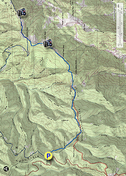
- Mile 0.0 – Park at Polls Gap. The actual parking spaces are limited, but the shoulders on both sides of the road are wide and can accommodate many cars. This is also the trailhead for the Rough Fork Trail. Follow the Hemphill Bald Trail southeast from the parking area.
- Mile 1.5 – The trail turns east at Garretts Gap following Cataloochee Divide. Instead of traveling along the top of the divide, the trail bypasses the crest on the north side through hardwood forests with an open understory.
- Mile 2.6 – Beginning at Maggot Spring Gap the trail now closely follows the national park boundary. The boundary is frequently characterized by a split-rail fence. You’ll encounter the first climb of the day out of the gap to Sheepback Knob and Little Bald Knob.
- Mile 4.0 – On the other side of Little Bald Knob the fencing changes to barbed wire when you pass through Pine Tree Gap. The land begins to open up on the south side of the trail. This is part of the Cataloochee Ranch property. The park boundary is now the dividing line between grassy fields to the south and hardwood forests to the north.
- Mile 4.4 – Climb out of Pine Tree Gap on a gradual approach to Hemphill Bald. You should be able to see the grassy summit of Hemphill Bald above. As you climb you’ll have increasingly better views towards the west.
- Mile 4.8 – Reach the summit of
Hemphill Bald. At 5,556 feet it is the second highest peak on
Cataloochee Divide behind Little Bald Knob. The summit is marked by a
stone picnic table shaded by a large majestic buckeye tree. You’ll have
stic 270° views from the cleared summit from north to east to south.
Towards the northeast in the foreground is Purchase Knob, with the Bald
Mountains and Newfound Mountains in the distance across the Pigeon
River Gorge. Crabtree Bald, the tallest peak in the Newfound Mountains,
is the southernmost peak on the highest ridge. Maggie Valley is located
due east far below the summit. The open slopes of the Cataloochee Ski
Area are visible on the right above Maggie Valley. In the distant east
Mount Pisgah and Cold Mountain are the two most prominent summits in
view. Towards the south-southeast beyond the Cataloochee Ski Area is
Richland Balsam, the tallest peak in the Great Balsam Mountains. The
dominant crest of the Plott Balsam Mountains is due south thousands of
feet of Maggie Valley and Soco Valley. The three tallest peaks in the
range – Plott Balsam, Mount Lyn Lowry, and Waterrock Knob – are
discernible left to right. You can choose to turn around here for a 9.6-mile hike or you can
continue on the Hemphill Bald Trail to connect with the Cataloochee
Divide Trail. The hike from Double Gap continues to Gooseberry Knob at
The Swag for more views for a 13.0-mile hike. This extra mileage is not
noticeably difficult except for the climb back up to Hemphill Bald on
the return leg.
- Mile 5.7 – The Hemphill Bald Trail turns left at a cross junction in Double Gap descending towards Caldwell Fork. Continue straight on the Cataloochee Divide Trail.
- Mile 5.8 - Pass by a fenced trail on the right to a Native American trail marker tree. On the return the hike explores this short side trip.
- Mile 6.1 – Trail access on the right for the Cataloochee Ranch.
- Mile 6.2 – Pass by gardens and parking lot for The Swag. You’ll then walk through a T-junction with an access trail for The Swag. After this junction the Cataloochee Divide Trail parallels a trail from The Swag on the other side of the fence.
- Mile 6.6 – Gooseberry Knob is only a minor peak on Cataloochee Divide, but The Swag maintains and clears the summit providing great views to the north and east. The summit is dotted with picnic tables, gazebos, recliner chairs, and tables. The resort generously allows hikers to visit the summit, so please respect their property. This locale is also known as Rogers Hideaway, you will see this sign at the entrance for a short walkway to an observation deck. The deck does not noticeably improve the views from the rest of the summit. Purchase Knob is the conical peak immediately northeast. You have similar views compared to Hemphill Bald east of Maggie Valley and the ranges beyond. In contrast, Gooseberry Knob offers a different perspective of the Cataloochee Ski Area. Looking south you can see the summit area of Hemphill Bald above the treeline. After you are finished exploring Gooseberry Knob, turn around and hike back towards Hemphill Bald.
- Mile 7.3 – If you desire you can take a quick detour on the left on The Swag’s trail to a Native American trail marker tree. You’ll have to hop the low fence here for this.
- Mile 7.4 – An unusual tree is denoted as an example of a Native American trail marker tree. Native Americans intentionally anchored branches to the ground on young trees to force them to bend horizontally as they grew. However, due to the relatively young age of this tree, it is unclear if this was actually bent for trail marking.
- Mile 7.5 – Rejoin the Cataloochee Divide Trail immediately before Double Gap. Once you pass through Double Gap you are faced with a 500-foot climb over 0.8-mi to Hemphill Bald.
- Mile 12.2 – Hike ends at Polls Gap.