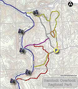
Along the banks of Bull Run near Clifton Virginia, Hemlock Overlook
Regional Park has 8 trails dedicated to hiking and horseback riding. The
perimeter circuit we have mapped here follows the banks of Bull Run
along the Bull Run/Occoquan Trail passing the ruins of Virginia's first hydroelectric dam. Hemlocks
can still be found on the red and yellow trails for which the park is
named. This hike is one of several that can be found along Bull Run,
including: Fountainhead Regional Park, Wolf Shoals, and Manassas Bull Run.
The main parking area is directly across from the Paradise Springs Winery, and a great way to spend the day is to hike the 3.8 mile perimeter circuit then walk over and enjoy a glass of wine on their large patio. The park also doubles as a accredited Outdoor Educational Center operated by Adventure Links. The group is focused on youth development, with a popular ropes course as part of the facilities.
- Mile 0.0 - Pass the kiosk and wooden posts then begin the hike down the wide yellow blazed trail. The trails are not named, however the colored trails have blazed trees in a horseshoe shape similar to markings found at Fountainhead Regional Park. The yellow blazed trail will arrive at the crossing of the red blazed trail in 0.13 miles.
- Mile 0.13 - Turn left onto the red blazed trail. Pass through a small ravine then walk along the ridge with the densest number of hemlocks. The trail then descends towards Bull Run and ends at the intersection of the Bull Run/Occoquan Trail.
- Mile 0.89 - Turn right on the blue blazed Bull Run/Occoquan Trail as it follows the banks of Bull Run. This section of Bull Run is 2.5 miles upstream from Occoquan Reservoir. The trail will traverse along a steep bluff and the rockiest section of the hike, the flatten out and pass the terminus of the yellow blazed trail at mile 1.29. Continue along the blue blazed trail and banks of Bull Run and arrive at the ruins of Virginia's first hydroelectric dam, and terminus of the purple blazed trail.
- Mile 1.68 - Continue along Bull Run and the blue blazed trail passing around another bend with a large stand of Mountain Laurel, as well as a section of the trail very close to the run. The trail becomes more flat and wider then arrives at Popes Head Creek. At this point the Bull Run/Occoquan Trail crosses the creek over several concrete pillions.
- Mile 2.38 - Turn right uphill on the yellow blazed trail and pass a view of Popes Head Creek through the trees. At the top of the ridgeline the yellow blazed trail will make a left at the next trail junction. The trail that continues is unblazed and ends at the Outdoor Educational Center.
- Mile 2.62 - Turn left on the yellow blazed trail heading downhill and arrive a the next intersection and creek. The unblazed trail right ends at the park pond.
- Mile 2.89 - Turn left staying on the yellow blazed trail. Shortly cross the creek where the trail begins to wind back to the right and climb the ridge. Pass through a small clearing and arrive at a house. Stay on the right of the yard following the yellow blazes passing a trail on the right leading to the park pond. Continue around the yard and turn right along the utility clear cut. Follow the clear cut and yellow blazes back to the parking area at the far end.
- Mile 3.3 - Arrive back at the parking are on Yates Ford Rd.