Loading...

🎉 Enjoy a Free 7-Day Supporter Trial and Unlock Exclusive Perks — No Credit Card Required. Learn more.

Hemlock Loop

Directions
Map
Pictures
Send to App
Distance:
0.2 Miles / 0.3 km
Type:
Loop
Difficulty:
Easy
Time to Hike:
~6 minutes
Features:
Surface Type:
Dirt
Park:
Personius Woods (Tanglewood Nature Center)
Town:
Big Flats, New York
Directions:
42.113737, -76.885525
Added:
December 31, 2023
Updated:
January 03, 2024
Copy Trail Link Hiking this trail? Send a friend or family member a link to this trail guide for your own safety. Hike at your own risk (disclaimer)
Loading...
Loading...
35'

Total Change
39'

Ascent
37'

Descent

Download the Trail Route for Offline Use

Supporters get exclusive access to download trail routes to the MyHikes app for offline use. Stay prepared on your adventure, even without an internet connection! Become a Supporter today to unlock this feature and hike with confidence.

Send to App

Hemlock Loop

The Hemlock Loop at Personius Woods (Tanglewood Nature Center) in Big Flats, New York is an easy 0.2-mile loop trail that runs along Hoffman Creek and features a beautiful hemlock forest.

Trails
This hike follows one named trail: Hemlock Loop (blue blazes)

Hike Description
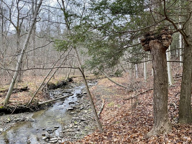
This short trail begins on the south side of the main parking lot at Personius Woods and heads southward. Hikers will reach a trail junction for the loop within a couple dozen feet from the trailhead -- this GPS track heads in a counter-clockwise direction. If following this track, hikers will head downhill toward Hoffman Creek first. The trail then runs along Hoffman Creek, passing a footbridge that starts the Scout Trail, and continues onward. After passing the footbridge, hikers will head up the small hill while passing through a hemlock forest to complete the loop at just 0.2-miles.

Parking
Hikers will find a small parking lot at the coordinates provided, located on the west side of West Hill Road in Elmira.

Pets
Dogs are allowed only if leashed and must be cleaned up after.
Explore 110 trails near Big Flats, NY
  1. Parking

    42.113737, -76.885525
  2. Main Trailhead

    42.113673, -76.885468
  3. Hoffman Creek

    42.112933, -76.885628
    Hoffman Creek
No community routes found. To add your own hike as a Community Route for this Trail guide, leave a Trip Report with an attached GPX file.

Hazards

Ticks - Lyme Disease More Info (CDC)
Poison Ivy/Oak

Seasons

All

Blaze Color

Blue

Weather Forecast

In Big Flats, NY

Explore Hiking Trails

You May Also Like

Colorado's Million Dollar Highway - Plan a day's drive adventure along the iconic Million Dollar Highway in Colorado. Explore the best short trails, roadside stops, waterfalls, vistas, ghost towns, and hot springs within a ~6 hour road trip.
Explore

Colorado's Million Dollar Highway

Plan a day's drive adventure along the iconic Million Dollar Highway in Colorado. Explore the best short trails, roadside stops, waterfalls, vistas, ghost towns, and hot springs within a ~6 hour road trip.

Read
Glacier's Going-to-the-Sun Road - Discover the breathtaking beauty of Glacier National Park along the iconic Going-to-the-Sun Road. From stunning roadside stops to picturesque waterfalls and vistas, this engineering marvel offers endless opportunities for exploration.
Explore

Glacier's Going-to-the-Sun Road

Discover the breathtaking beauty of Glacier National Park along the iconic Going-to-the-Sun Road. From stunning roadside stops to picturesque waterfalls and vistas, this engineering marvel offers endless opportunities for exploration.

Read
New York's Best Waterfalls - Whether you're planning a day hike, roadside stop, or a leisurely short walk, this guide provides hikers, travelers, and locals alike with 63 different locations to over 100 scenic waterfalls to help plan your next adventure!
Explore

New York's Best Waterfalls

Whether you're planning a day hike, roadside stop, or a leisurely short walk, this guide provides hikers, travelers, and locals alike with 63 different locations to over 100 scenic waterfalls to help plan your next adventure!

Read

Before you boogie...

Find our trail guides useful? Consider becoming a Supporter to unlock perks!

MyHikes is an indie platform that makes exploring public trails easier for everyone. The platform has no investors, no ads, and is owned and operated by one person, Dave Miller. Dave has personally mapped and written over 1,800 trail guides on MyHikes for the public to explore. MyHikes has helped millions outdoor enthusiasts plan their next adventure.

But it takes a lot of time 🕦, money 💰, work, and espresso shots ☕ to run MyHikes, including hiking , mapping , writing , and publishing new trails with high-quality (accurate) information... along with software engineering (coding) the platform like building new features, website and mobile app development (iOS and Android), site maintainance . and much much more.

Supporters unlock website and mobile app perks with an annual one-time payment of $25 (you renew) 😎👍. Or you can simply make a Donation of your choice. Otherwise, you can support us by telling your friends about MyHikes - both quick and free 🎉

Admin user profile picture

Dave Miller
MyHikes Founder