Loading...

Distance:
0 Miles / 0 km
Type:
Out-and-Back
Difficulty:
Easy
Time to Hike:
~5 minutes
Features:
Surface Type:
Universal Access
Park:
Grand Staircase-Escalante National Monument
Town:
Escalante, Utah
Directions:
37.746748, -111.453998
Added:
September 26, 2023
Updated:
October 04, 2023
Loading...
Loading...
16 '

Total Change
16 '

Ascent
16 '

Descent

The Head of the Rocks Overlook at the Grand Staircase-Escalante National Monument near Escalante, Utah is an easy 0.1-mile out-and-back walk 
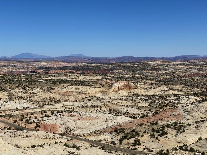
that features views of .

This is not a hike but rather a short universally-accessible walk along a paved path that features views from the Head of the Rocks. This is a great spot to take a break on a long road trip through Utah. From the viewpoint, visitors get big sky views over the Grand Staircase-Escalante National Monument including points-of-interest below your feet like the Maverick Natural Bridge, Phipps Arch, and more.

Universal Access
This vista point has a universally-accessible paved path that reaches the viewing area and information kiosks.

Parking
Visitors will find a large parking lot at the coordinates provided.

Pets
Dogs are allowed if leashed and must be cleaned up after.

Explore 12 trails near Escalante, UT
  1. Parking

    37.746748, -111.453998
  2. Main Trailhead

    37.746748, -111.453998
  3. Head of the Rock Overlook

    37.746617, -111.453828
    Head of the Rock Overlook
No community routes found. To add your own hike as a Community Route for this Trail guide, leave a Trip Report with an attached GPX file.

Hazards

Snakes

Seasons

All

Photo Albums

2 Trip Reports

No Star-Ratings
Write-up by:
Admin user profile picture
0 miles / 0 km
Trail added
September 26, 2023
Hiked on
September 26, 2023
Updated on
October 04, 2023
0 miles / 0 km
September 26, 2023
Hiking

Weather Forecast

In Escalante, UT

Explore Hiking Trails

New Hikes

Upper Rattler Run Falls
1.9 Miles
3.1 km
Hard
Out-and-Back
Keshequa Creek Falls Trail
2.9 Miles
4.7 km
Easy
Out-and-Back
Diana's Baths Trail
1.2 Miles
1.9 km
Easy
Out-and-Back
Coquina Loop (Old Levi Mill Waterfall)
1.7 Miles
2.7 km
Moderate
Loop

Before you leave...

MyHikes is an indie web platform aimed to make exploring public trails easier for everyone. The site has no investors and is owned and operated by one person, Dave Miller (Founder & Admin). As the Founder, main contributor, and doer-of-all-things for MyHikes, I share my trips with over-detailed write-ups for fun on a volunteer basis and I believe that public trail information should be available to everyone.

It takes a lot of time 🕦, money 💰, and effort (including espresso shots ☕) to run MyHikes, including hiking , mapping , writing , and publishing new trails with high-quality content... along with building new features, moderating, site maintainance, and app development for iOS and Android . I simply ask that if you find MyHikes' trail guides helpful to please consider becoming a Supporter to help keep the site, iOS, and Android apps available to everyone.

Supporters unlock website and in-app perks with a one-time payment of $25 (you renew) 😎👍. Or you can simply make a Donation of your choice without a MyHikes user account. Otherwise, telling your friends about MyHikes is the next-best thing - both quick and free 🎉

Thanks for visiting MyHikes and have a great hike!️

Admin user profile picture

Dave Miller
MyHikes Founder & Admin