Hawk Rock via Appalachian Trail in Duncannon, Pennsylvania is a moderate 2.4-mile loop hike that features two vistas including Hawk Rock and Eagles Edge Vista.
Trails
This hike follows these trails in order: Unnamed Entrance Trail (yellow blazes), Appalachian Trail (white blazes), Unnamed Mountain Ridge Trail (no blazes), Appalachian Trail, Unnamed Entrance Trail.
Hike Length
Note that hikers can skip the short 0.25-mile out-and-back segment of this trail that leads to the 2nd "Hawk Rock Vista" which sits to the West of the actual location of Hawk Rock. The mapbox map tiles depict another vista but upon inspection, there was nothing there. This note and data exists so hikers don't go looking for nothing. By skipping that section, this hike should be considered a 2.1-mile loop.
Hike Type (Loop vs. Out-and-Back)
Most people hike to Hawk Rock as an out-and-back, however, this track follows a loop to reach the Eagles Edge Vista -- note that the trail that connects from Eagles Edge Vista down to parking is extremely rocky and annoying to hike on, in addition to at least one very steep cliff drop-off. For this reason, this is usually hiked as an out-and-back.
Hike Description
This hike begins at the large parking lot for the Appalachian Trail and Hawk Rock / Hawk Rock Mountain at the coordinates provided located at the end of Watershed Drive in Duncannon, PA. The trailhead is located on the southwest corner and has proper signage. Hikers will first follow a connector trail from the parking lot to the Appalachian Trail -- this connector trail follows yellow blazes.
Appalachian Trail to Hawk Rock - Mile 0.15 to 0.9
At mile 0.15, hikers will head straight onto the white blazed Appalachian Trail as it begins to ascend Hawk Rock Mountain. Along the way, the trail will mostly be made-up up dirt with seldom rocks, but that changes over time. As the Appalachian Trail ascends Hawk Rock Mountain, the trail hits more and more exposed rock field areas -- while there are no active rockfalls, the trail leads through stone steps to traverse these rock fields. Soon after the rock fields, the trail will ascend via switchbacks as it gets closer to Hawk Rock and its overlook.
Hawk Rock Overlook / Vista - Mile 0.9
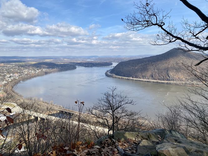
At mile 0.9, hikers will reach the top of the mountain where the rocky outcropping known as Hawk Rock sits. From Hawk Rock, hikers get panoramic views northward into Pennsylvania -- including views of the Susquehanna River and the town of Duncannon. Here, hikers have reached the most sought-after destination on the hike. At Hawk Rock you can choose to hang around and enjoy the views, assuming the crowds are small or nonresistant, or you can continue hiking onward -- this guide leads you to Eagles Edge Vista next.
Appalachian Trail Campsite - Mile 0.95
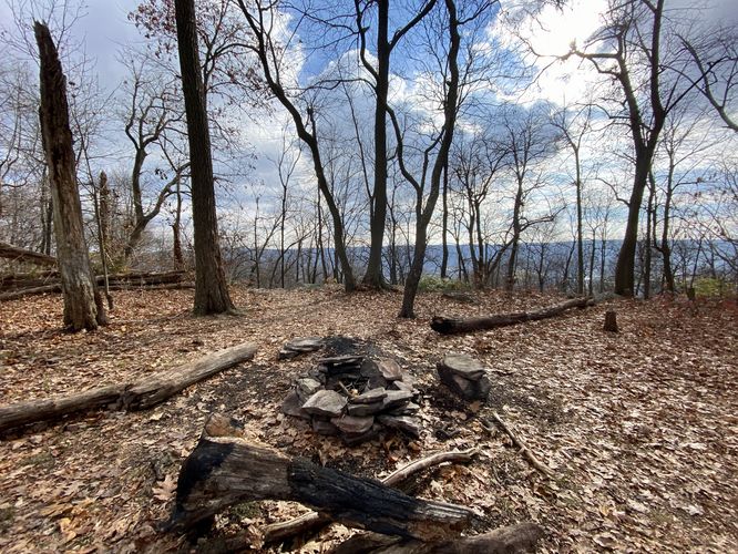
After visiting Hawk Rock Overlook / Hawk Rock Vista, hikers will head up the small hill behind to reach the summit of Hawk Rock Mountain. At the summit is a campsite located around mile 0.95, right on the Appalachian Trail.
Walk to Nowhere - Mile 0.95 to 1.25
This GPS track includes a hike along the ridge of Hawk Rock Mountain to a POI on the map labeled "Hawk Rock" with a vista marker; however, nothing actually exists there. This guide will include mileage for both the GPS data provided AND for those who are planning to skip this short 0.3-miles of walking.
Hike to Eagles Edge Vista - Mile 1.25 to 1.85 (0.95 to 1.55)
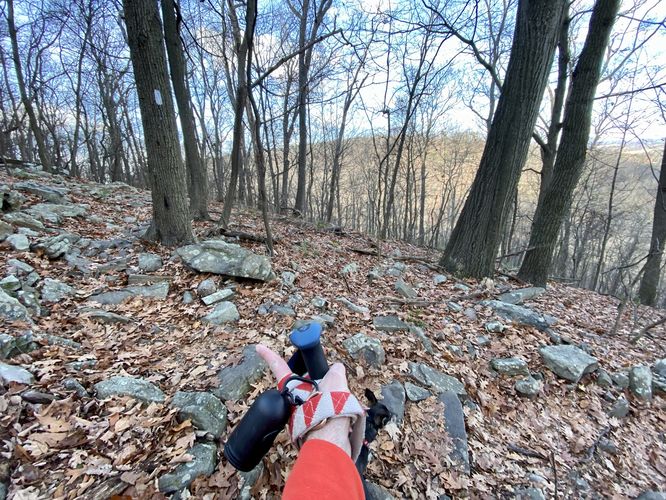
Once on the top of Hawk Rock Mountain's ridge (at the Appalachian Trail campsite), the hike to reach Eagles Edge Vista is straight forward. Hike the ridge trail as it leads northeast from the campsite and walk for 0.6 miles. The hiking is flat and relatively easy until you reach the last 0.1-miles where the trail's surface turns into a very rocky substrate. On this hike, one of us fell and got really bruised up but thankfully no broken bones or worse.
Eagles Edge Vista - Mile 1.85 (1.55)
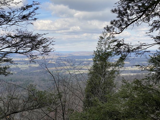
At mile 1.85 (in the GPS data), or mile 1.55 if skipping that small section, hikers will reach the Eagles Edge Vista. At the Eagles Edge Vista, you'll find stunning views of the Susquehanna River, Duncannon PA, and the mountain across the valley where the Appalachian Trail continues onward as it makes it's journey toward Katahdin. The Eagles Edge Vista is the last place to truly sit, relax, and enjoy the views before descending the grueling and steep rock-filled trail ahead of you.
Descending Hawk Rock Mountain - Mile 1.85 to 2.1
After visiting Eagles Edge Vista, hikers will be faced with the frustrating downhill hike. First, it starts-off by following the top of a super-steep ~30-foot tall cliff. Watch your step, seriously. After that, the trail is littered with large rocks that can easily twist and ankle. Using trekking poles can help a lot on this hike. Watch your step and take it slow as you descend the mountain. One important note -- you must take a left-hand turn on the Appalachian Trail around mile 2.1 otherwise you might hike toward the Susquehanna River.
Appalachian Trail to Parking - Mile 2.1 to 2.4
After taking a left-hand turn onto the AT, hikers will follow that for a few-hundred feet before reaching the yellow-blazed parking lot connector trail. Take a right-hand turn at the connector to hike back to parking for a 2.4-mile (or 2.1-mile) loop hike.
Parking
Hikers will find a large parking lot at the end of Watershed Drive in Duncannon, PA at the coordinates provided. The lot is large enough to fit several dozen vehicles.
Pets
Dogs are allowed only if leashed and must be cleaned up after.
Popularity
This is one of the most-popular day hikes near Harrisburg, PA so plan on seeing plenty of other people on the trail.
Warnings
Steep cliffs: This trail passes by steep cliffs with sheer drop-offs. Watch your step and hike at your own risk.
Rocky terrain: This loop passes through trail surfaces where there are a ton of rocks of varying sizes, which makes it difficult to walk on. Trekking poles help with this but it's easy to twist an ankle or worse. Hike at your own risk.
Trails
This hike follows these trails in order: Unnamed Entrance Trail (yellow blazes), Appalachian Trail (white blazes), Unnamed Mountain Ridge Trail (no blazes), Appalachian Trail, Unnamed Entrance Trail.
Hike Length
Note that hikers can skip the short 0.25-mile out-and-back segment of this trail that leads to the 2nd "Hawk Rock Vista" which sits to the West of the actual location of Hawk Rock. The mapbox map tiles depict another vista but upon inspection, there was nothing there. This note and data exists so hikers don't go looking for nothing. By skipping that section, this hike should be considered a 2.1-mile loop.
Hike Type (Loop vs. Out-and-Back)
Most people hike to Hawk Rock as an out-and-back, however, this track follows a loop to reach the Eagles Edge Vista -- note that the trail that connects from Eagles Edge Vista down to parking is extremely rocky and annoying to hike on, in addition to at least one very steep cliff drop-off. For this reason, this is usually hiked as an out-and-back.
Hike Description
This hike begins at the large parking lot for the Appalachian Trail and Hawk Rock / Hawk Rock Mountain at the coordinates provided located at the end of Watershed Drive in Duncannon, PA. The trailhead is located on the southwest corner and has proper signage. Hikers will first follow a connector trail from the parking lot to the Appalachian Trail -- this connector trail follows yellow blazes.
Appalachian Trail to Hawk Rock - Mile 0.15 to 0.9
At mile 0.15, hikers will head straight onto the white blazed Appalachian Trail as it begins to ascend Hawk Rock Mountain. Along the way, the trail will mostly be made-up up dirt with seldom rocks, but that changes over time. As the Appalachian Trail ascends Hawk Rock Mountain, the trail hits more and more exposed rock field areas -- while there are no active rockfalls, the trail leads through stone steps to traverse these rock fields. Soon after the rock fields, the trail will ascend via switchbacks as it gets closer to Hawk Rock and its overlook.
Hawk Rock Overlook / Vista - Mile 0.9
At mile 0.9, hikers will reach the top of the mountain where the rocky outcropping known as Hawk Rock sits. From Hawk Rock, hikers get panoramic views northward into Pennsylvania -- including views of the Susquehanna River and the town of Duncannon. Here, hikers have reached the most sought-after destination on the hike. At Hawk Rock you can choose to hang around and enjoy the views, assuming the crowds are small or nonresistant, or you can continue hiking onward -- this guide leads you to Eagles Edge Vista next.
Appalachian Trail Campsite - Mile 0.95
After visiting Hawk Rock Overlook / Hawk Rock Vista, hikers will head up the small hill behind to reach the summit of Hawk Rock Mountain. At the summit is a campsite located around mile 0.95, right on the Appalachian Trail.
Walk to Nowhere - Mile 0.95 to 1.25
This GPS track includes a hike along the ridge of Hawk Rock Mountain to a POI on the map labeled "Hawk Rock" with a vista marker; however, nothing actually exists there. This guide will include mileage for both the GPS data provided AND for those who are planning to skip this short 0.3-miles of walking.
Hike to Eagles Edge Vista - Mile 1.25 to 1.85 (0.95 to 1.55)
Once on the top of Hawk Rock Mountain's ridge (at the Appalachian Trail campsite), the hike to reach Eagles Edge Vista is straight forward. Hike the ridge trail as it leads northeast from the campsite and walk for 0.6 miles. The hiking is flat and relatively easy until you reach the last 0.1-miles where the trail's surface turns into a very rocky substrate. On this hike, one of us fell and got really bruised up but thankfully no broken bones or worse.
Eagles Edge Vista - Mile 1.85 (1.55)
At mile 1.85 (in the GPS data), or mile 1.55 if skipping that small section, hikers will reach the Eagles Edge Vista. At the Eagles Edge Vista, you'll find stunning views of the Susquehanna River, Duncannon PA, and the mountain across the valley where the Appalachian Trail continues onward as it makes it's journey toward Katahdin. The Eagles Edge Vista is the last place to truly sit, relax, and enjoy the views before descending the grueling and steep rock-filled trail ahead of you.
Descending Hawk Rock Mountain - Mile 1.85 to 2.1
After visiting Eagles Edge Vista, hikers will be faced with the frustrating downhill hike. First, it starts-off by following the top of a super-steep ~30-foot tall cliff. Watch your step, seriously. After that, the trail is littered with large rocks that can easily twist and ankle. Using trekking poles can help a lot on this hike. Watch your step and take it slow as you descend the mountain. One important note -- you must take a left-hand turn on the Appalachian Trail around mile 2.1 otherwise you might hike toward the Susquehanna River.
Appalachian Trail to Parking - Mile 2.1 to 2.4
After taking a left-hand turn onto the AT, hikers will follow that for a few-hundred feet before reaching the yellow-blazed parking lot connector trail. Take a right-hand turn at the connector to hike back to parking for a 2.4-mile (or 2.1-mile) loop hike.
Parking
Hikers will find a large parking lot at the end of Watershed Drive in Duncannon, PA at the coordinates provided. The lot is large enough to fit several dozen vehicles.
Pets
Dogs are allowed only if leashed and must be cleaned up after.
Popularity
This is one of the most-popular day hikes near Harrisburg, PA so plan on seeing plenty of other people on the trail.
Warnings
Steep cliffs: This trail passes by steep cliffs with sheer drop-offs. Watch your step and hike at your own risk.
Rocky terrain: This loop passes through trail surfaces where there are a ton of rocks of varying sizes, which makes it difficult to walk on. Trekking poles help with this but it's easy to twist an ankle or worse. Hike at your own risk.