Loading...

🍂 Prep for Fall! Unlock exclusive features to plan your perfect late-summer and autumn hikes — become a Supporter today. Learn more.

Hardscrabble Knob Hike

Directions
Map
Pictures
Send to App
Distance:
7.0 Miles / 11.3 km
Type:
Out-and-Back
Difficulty:
Moderate
Time to Hike:
3 hours, ~30 minutes
Features:
Surface Type:
Dirt
Park:
George Washington National Forest
Town:
West Augusta, Virginia
Directions:
38.36879, -79.273576
Added:
January 27, 2025
Updated:
April 04, 2025
Guide by:
Copy Trail Link Hiking this trail? Send a friend or family member a link to this trail guide for your own safety. Hike at your own risk (disclaimer)
Loading...
Loading...
1,910'

Total Change
2,172'

Ascent
2,172'

Descent

Download the Trail Route for Offline Use

Supporters get exclusive access to download trail routes to the MyHikes app for offline use. Stay prepared on your adventure, even without an internet connection! Become a Supporter today to unlock this feature and hike with confidence.

Send to App

Key Takeaways

  • Hardscrabble Knob is a challenging 7-mile hike in West Augusta, VA, known for its steep initial ascent of over 1,000 feet in the first mile.
  • The hike can be combined with other trails in the Todd Lake area and enjoyed as a multi-day camping trip along FR95 or at Todd Lake Recreation Area.
  • The trail description provides detailed directions, including landmarks like Hiner Spring, campsites, and junctions, to help hikers navigate the route to the summit overlook and back.

Hardscrabble Knob Hike

This hike is a tough workout. At 7 miles, and just over 2,000 vertical feet total gain, you climb over 1,000 feet of that in the first mile. Hardscrabble Knob is just one of several hikes in the Todd Lake area. Consider hiking several of them and car-camping at one of the many sites along FR95, or at one of Todd Lake Recreation Area's great campsites.

A great way to spend the weekend is to camp along North River and hike south along the Wild Oak Trail to Hardscrabble Knob one day, then hike up to the Little Bald Knob Ridge from the camping area the next. There are also several other hikes located in this trail system within a 10 minute drive, including Trimble Mountain, North River Gorge, and Sand Spring Mountain.

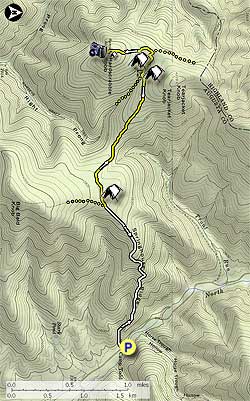
From the Camp Todd forestry sign and parking area head west on a small dirt road (Camp Todd sign side of FR95) for 30 yards until the dirt road turns right. Now stay straight on the smaller white blazed Wild Oak Trail, and in 50 yards pass one of only a few faded white blazes and forestry service sign marking the trail. At this point the trail begins its long climb up through the gorge and along Springhouse Ridge. The trail makes several small switchbacks before beginning to level off at 1.2 miles. At 1.5 miles from the hike start point arrive at the intersection of the Little Bald Knob Trail.

Turn right as trail passes a small campsite in 50 yards, then continues through the gap for another 1.3 miles before arriving at Hiner Spring and the intersection of the Ramsey's Draft Trail. Turn right uphill and immediately pass between Hiner Spring 50 yards to the left, and a popular campsite on the right.

In another 25 yards the trail splits. Taking the right fork, that looks like a washed out trail section, heads the more direct route. Taking the left fork makes a small detour to one of the prettiest high mountain campsites in the area. Thick grass and fern surround the site in the warmer months. This campsite is also less rocky than the one at Hiner Spring. In 20 yards past the campsite the trails re-join before making a quick switchback over a small burn, and arriving at the trail junction to Hardscrabble Knob.

Turn left uphill towards Hardscrabble Knob following the trail for 0.5 miles. Just below the summit pass an abandoned cabin and small high mountain campsite and in 30 yards the trail turns to the left. Pass through the steel ruins of an old lookout tower and climb 15 feet through a seam in the rocks to the summit.

Scramble to the right along the rocky ridge line for 75 yards to the overlook, passing a USGS marker at about halfway that was placed there in 1957. From the overlook you can see Elliot Knob at at 190° in the distance, the highest peak in the GWNF. The undulating ridge immediately in the foreground is Bald Ridge, part of the Ramsey's Draft hike.

This is an out and back hike so to return retrace your steps.

NOTE: Be alert at Hiner Spring not to miss the return trail to the left marked by an old sign on a tree.

Explore 29 trails near West Augusta, VA
  1. Parking

    38.36879, -79.273576
  2. Main Trailhead

    38.36879, -79.273576
No community routes found. To add your own hike as a Community Route for this Trail guide, leave a Trip Report with an attached GPX file.

Hazards

Ticks - Lyme Disease More Info (CDC)
Snakes
Poison Ivy/Oak

Seasons

All

Blaze Color

Yellow

Photo Albums

+ Add Photo Album

Upload your photos from the trail to help others know what to expect.

Trip Reports (Reviews)

Rated 3.0 out of 5 based on 4 ratings.
By: The Mayne Line
7.0 miles / 11.3 km
August 11, 2018
I wanted a good intro backpack for my two daughters 19 & 27. This proved to be just the ticket. We walked it counter clockwise. We did get our feet wet straight out of the gate at the initial crossing of Ramsey’s draft. Perhaps we could have found a more shallow crossing. Then it was fairly straight going. The trail got was not marked very well around Gordon’s Peak. I believe this is where we had a bit of a scramble up some rocky outcrops. As the other reviews said: There is a good amount of poison ivy on this trail. No water available on this side of the hill. (There is a “pond”. I personally would not drink it unless I was VERY thirsty.) We were not moving very quickly. It took us 7 hours to walk from parking lot to Hiner Spring We camped at Hiner Spring. Very nice. We had the place to ourselves. We only saw 2 hikers in the parking lot. No one else on the trail the whole weekend. Coming out of Hiner Spring the trail is very rocky and NOT marked. The first mile or so is "interesting" in a rocky sort of way. We did not see a single blaze the length of Ramsey’s draft. Most of the time we were ok. There was one point about 3 miles out of Hiner Spring, the trail crossed the Ramsey’s draft… we did not. We were able to pick the trail back up. Yes stinging nettles where abundant, but with long pants we did not have any trouble. Hiking poles are VERY useful for all the stream crossings. No, you cannot not keep you feet dry on day 2. Took about 5 hours to hike down without stopping. Over all a great intro to hiking for my daughters. Very pretty walk in the woods. No great vistas but a few peek-a-boo’s. Lovely creek. Getting mildly lost and not freaking out is a good lesson. Many very cool looking mushrooms. We did see a bit of bear scat. We saw the remains of a baby black bear. Not sure what got it. I got what I wanted. Great two days with my daughters. Somewhat physically challenging but not “gonna kill you”.
Legacy Review
By: Brian
7.0 miles / 11.3 km
March 26, 2016
A short but tough hike with a decent view at the end. I hiked this on a beautiful spring Saturday with 12 friends from Central Virginia Trailblazers as part of our "CVT Knobsession 2016" series of hikes. Except for a few campers, we were the only ones on the trail. The directions were pretty accurate, but some folks calculated the total distance as being closer to 8 miles. It took us about 4 hours to get to the top and back including a 20 minute break for lunch.
Legacy Review
By: eshank24
7.0 miles / 11.3 km
August 17, 2012
I hiked this trail Friday late afternoon, spent the night at a campsite a half mile below hardscrabble knob, and hiked back down Saturday morning. The first mile of this hike is no joke, it's almost straight up the whole way with only a few switchbacks to make it a little easier. It's very very tough at the start, and then the trail starts to gradually flatten out as you near the top. Make sure to take the right fork at the "wilderness behind this sign" sign, even though the white blazed trail goes left. The campsites near the top are beautiful and are really nice places to unload your stuff. There's a decent view on the top, though it's nothing spectacular. Also, true to the trail ratings, there are no streams or running water anywhere along the way so be sure to bring plenty of water. If you can handle a harsh first mile of uphill trail, it's a really nice hike, and the day I was there, almost nobody else was great solitude.
Legacy Review

Weather Forecast

In West Augusta, VA

Explore Hiking Trails

You May Also Like

New York's Best Waterfalls - Whether you're planning a day hike, roadside stop, or a leisurely short walk, this guide provides hikers, travelers, and locals alike with 63 different locations to over 100 scenic waterfalls to help plan your next adventure!
Explore

New York's Best Waterfalls

Whether you're planning a day hike, roadside stop, or a leisurely short walk, this guide provides hikers, travelers, and locals alike with 63 different locations to over 100 scenic waterfalls to help plan your next adventure!

Read
25 Best Day Hikes in North Carolina - Discover the top 25 best day hikes in North Carolina, from breathtaking waterfalls to mountain peaks. Explore hidden gems, scenic views, and trails suitable for all skill levels, perfect for your next outdoor adventure.
Explore

25 Best Day Hikes in North Carolina

Discover the top 25 best day hikes in North Carolina, from breathtaking waterfalls to mountain peaks. Explore hidden gems, scenic views, and trails suitable for all skill levels, perfect for your next outdoor adventure.

Read

Before you boogie...

Find our trail guides useful? Consider becoming a Supporter to unlock perks!

MyHikes is an indie platform that makes exploring public trails easier for everyone. The platform has no investors, no ads, and is owned and operated by one person, Dave Miller. Dave has personally mapped and written over 1,800 trail guides on MyHikes for the public to explore. MyHikes has helped millions outdoor enthusiasts plan their next adventure.

But it takes a lot of time 🕦, money 💰, work, and espresso shots ☕ to run MyHikes, including hiking , mapping , writing , and publishing new trails with high-quality (accurate) information... along with software engineering (coding) the platform like building new features, website and mobile app development (iOS and Android), site maintainance . and much much more.

Supporters unlock website and mobile app perks with an annual one-time payment of $25 (you renew) 😎👍. Or you can simply make a Donation of your choice. Otherwise, you can support us by telling your friends about MyHikes - both quick and free 🎉

Admin user profile picture

Dave Miller
MyHikes Founder