A long day hike at almost 12 miles, this hike has a couple of outstanding features. The hidden 30ft Falls Run waterfall is the prettiest waterfall on Great North Mountain, and the vistas from the Great North Mountain ridge west into West Virginia are panoramic. The second section of the hike down the steep pipeline clear cut is very rocky, and there is no shade. An alternate shorter hike that still passes the falls is the 6.9 mile Falls Ridge hike that descends Stack Rock Trail.
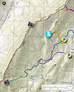
To access the hike, follow FR252 all the way to the permanently closed gate 0.1 miles from the Falls Ridge Trail intersection. FR252 is only open from April 1 - May 21 and Aug 1 - Dec 31. The hike can still be done when FR252 is closed by parking at the end of VA701/Dellinger Gap Rd. at the lower terminus of the yellow blazed Falls Ridge Trail. This will add 0.5 miles for a total hike length of 12.2 miles.
To access the hike, follow FR252 all the way to the permanently closed gate 0.1 miles from the Falls Ridge Trail intersection. FR252 is only open from April 1 - May 21 and Aug 1 - Dec 31. The hike can still be done when FR252 is closed by parking at the end of VA701/Dellinger Gap Rd. at the lower terminus of the yellow blazed Falls Ridge Trail. This will add 0.5 miles for a total hike length of 12.2 miles.
- Mile 0.0 - Pass around the closed gate and continue along FR252 on the blue blazed trail for 0.1 miles to the intersection where the yellow blazed Falls Ridge Trail crosses the road.
- Mile 0.1- Turn right uphill on the yellow blazed Falls Ridge Trail. The trail becomes increasingly more steep for the first 0.6 miles to the intersection of the unofficial side trail to the Falls Run waterfall.
- Mile 0.7- Look for a small rock cairn marking the side trail, however it is well worn and hard to miss. Turn left on the side trail that passes through Mountain Laurel. At this point the trail is intermittently marked with faint colored blazes. In 0.16 miles the trail will split.
- Mile 1.0 - Turn left downhill (continuing straight will take you to the upper section of Falls Run). This section of the side trail is intermittently red blazed, but is harder to follow than the previous section. As you get closer to the run, the trail falls pass through a section of rhododendron then arrives at the waterfall and 60ft cliff. Pass carefully over the boulders down to the foot of the waterfall.
- Mile 1.3 - Return back to the yellow blazed Falls Ridge Trail. Be cautious on the return after passing back through the rhoterdendrum. The trail is very faint and hard to follow.
- Mile 2.1 - Turn left uphill on the yellow blazed Falls Ridge Trail. The Falls Ridge Trail will pass through another stand of Mountain Laurel before ending at the ridge and intersection of the North Mountain Trail.
- Mile 3.35 - Turn left on the orange blazed Great North Mountain Trail continuing on the ridge for 4.1 miles, with several great views on both sides of the mountain, before arriving at a transmitting tower installation.
- Mile 7.8 - Cross the FS road and pass the closed gate staying to the right of the installation following the orange blazes as you turn left slightly uphill to the ridge in another 100 yards.
- Mile 7.9 - Steeply descend either of the two (they parallel each other) underground gas pipeline clear cuts as they go steeply downhill, then cross a FS road in 0.4 miles. Continue steeply downhill for another 0.5 miles before the clear cut flattens out. In 0.3 miles after the clear cut flattens out look for the blue blazes and small rock pile on the left where you will cross the stream and take the blue blazed trail.
- Mile 9.1 - After crossing the stream follow the blue blazed trail as it turns uphill for a short distance before turning right and traversing the mountain for 1.2 miles where the purple blazed trail will enter from the right. Continue on the blue blazed trail for another 1.4 miles back to the closed gate and parking area on FR252
- Mile 10.8 - Arrive back at the parking area on FR252.