Loading...

🎉 Enjoy a Free 7-Day Supporter Trial and Unlock Exclusive Perks — No Credit Card Required. Learn more.

Rhododendron Trail

Directions
Map
Pictures
Send to App
Distance:
1.3 Miles / 2.1 km
Type:
Out-and-Back
Difficulty:
Moderate
Time to Hike:
~39 minutes
Features:
Surface Type:
Dirt
Park:
Grayson Highlands State Park
Town:
Mouth of Wilson, Virginia
Directions:
36.633314, -81.509174
Added:
September 06, 2017
Updated:
July 04, 2020
Copy Trail Link Hiking this trail? Send a friend or family member a link to this trail guide for your own safety. Hike at your own risk (disclaimer)
Loading...
Loading...
217'

Total Change
226'

Ascent
227'

Descent

Download the Trail Route for Offline Use

Supporters get exclusive access to download trail routes to the MyHikes app for offline use. Stay prepared on your adventure, even without an internet connection! Become a Supporter today to unlock this feature and hike with confidence.

Send to App

Rhododendron Trail

The Rhododendron Trail at Grayson Highlands State Park in Mouth of Wilson, Virginia is one of the most popular hikes at the park because the trail leads to one of the most populated areas for viewing the Grayson Highlands wild ponies.
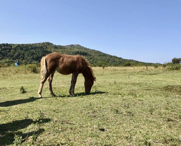
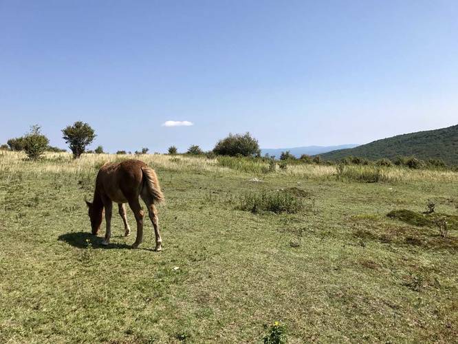
The wild ponies live year-round at 4,000+ foot elevations and there are about 120 of them at Grayson Highlands. The hike up to the ponies is just over 0.6 miles one-way, thus the 1.3 mile out-and-back trip. It's mostly uphill, so it's a moderate hike for people who don't regularly hike.

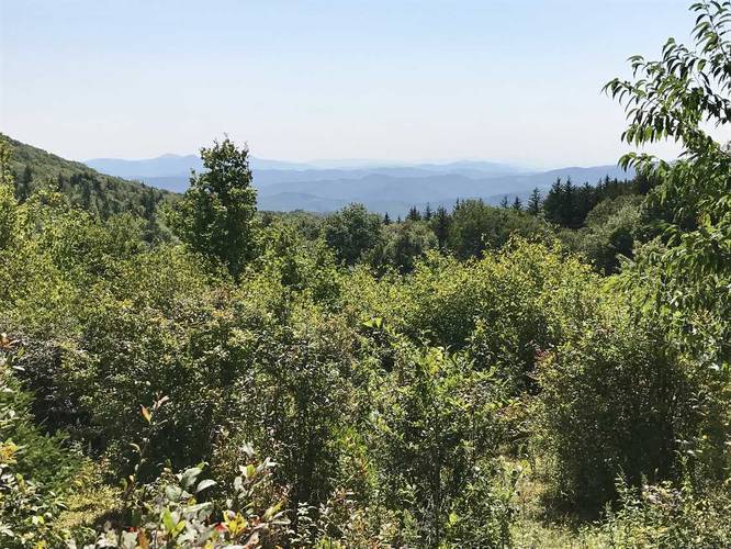
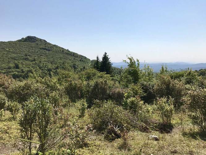
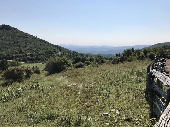
This trail is extremely popular and you cannot miss parking on the road - just look for the massive collection of cars and follow the hikers up the hill. At the top you'll likely find a couple of wild ponies, with a ton of people around them. Take your time, give them distance, and do not touch the wild animals. There are amazing views from the trail as well of the Appalachian Mountains in Virginia and TN.

Fees
As of 2017, the park charges $5 for in-state vehicles and $7 for out of state, but it's well worth the money to see the wild ponies and to check out the Grayson Highlands Overlook Trail.

Parking
Hikers can find parking along the road near the coordinates provided. Plenty of main parking lots exist, but are often completely full, hence the road parking.

Pets
Dogs are allowed if leashed and their waste must be carried out by the hiker. Also note that it's probably best to not bring your dogs along this hike if you want to enjoy the wildlife.
Explore 19 trails near Mouth of Wilson, VA
  1. Parking

    36.633314, -81.509174
  2. Main Trailhead

    36.633769, -81.509237
  3. Vista along the trail

    36.635739, -81.510703
    Vista along the trail
  4. Vista along the trail

    36.636089, -81.510231
    Vista along the trail
  5. Wild pony

    36.640025, -81.506942
    Wild pony
  6. Wild pony

    36.640111, -81.507011
    Wild pony
  7. Vista along the trail

    36.636464, -81.508928
    Vista along the trail
No community routes found. To add your own hike as a Community Route for this Trail guide, leave a Trip Report with an attached GPX file.

Hazards

Ticks - Lyme Disease More Info (CDC)

Season

Summer

Blaze Color

Blue

Trip Reports

Trail Guide By:
Admin user profile picture
1.3 miles / 2.1 km
1.2 miles / 1.9 km
September 03, 2017
Hiking

Weather Forecast

In Mouth of Wilson, VA

Explore Hiking Trails

You May Also Like

New York's Best Waterfalls - Whether you're planning a day hike, roadside stop, or a leisurely short walk, this guide provides hikers, travelers, and locals alike with 63 different locations to over 100 scenic waterfalls to help plan your next adventure!
Explore

New York's Best Waterfalls

Whether you're planning a day hike, roadside stop, or a leisurely short walk, this guide provides hikers, travelers, and locals alike with 63 different locations to over 100 scenic waterfalls to help plan your next adventure!

Read
25 Best Day Hikes in North Carolina - Discover the top 25 best day hikes in North Carolina, from breathtaking waterfalls to mountain peaks. Explore hidden gems, scenic views, and trails suitable for all skill levels, perfect for your next outdoor adventure.
Explore

25 Best Day Hikes in North Carolina

Discover the top 25 best day hikes in North Carolina, from breathtaking waterfalls to mountain peaks. Explore hidden gems, scenic views, and trails suitable for all skill levels, perfect for your next outdoor adventure.

Read

Before you boogie...

Find our trail guides useful? Consider becoming a Supporter to unlock perks!

MyHikes is an indie platform that makes exploring public trails easier for everyone. The platform has no investors, no ads, and is owned and operated by one person, Dave Miller. Dave has personally mapped and written over 1,800 trail guides on MyHikes for the public to explore. MyHikes has helped millions outdoor enthusiasts plan their next adventure.

But it takes a lot of time 🕦, money 💰, work, and espresso shots ☕ to run MyHikes, including hiking , mapping , writing , and publishing new trails with high-quality (accurate) information... along with software engineering (coding) the platform like building new features, website and mobile app development (iOS and Android), site maintainance . and much much more.

Supporters unlock website and mobile app perks with an annual one-time payment of $25 (you renew) 😎👍. Or you can simply make a Donation of your choice. Otherwise, you can support us by telling your friends about MyHikes - both quick and free 🎉

Admin user profile picture

Dave Miller
MyHikes Founder