The Grand View Point Trail at Canyonlands National Park near Moab, Utah is an easy 2-mile out-and-back trail that features stunning cliff-side views and leads to a stunning panoramic vista point at the end of the trail.
Hike Description
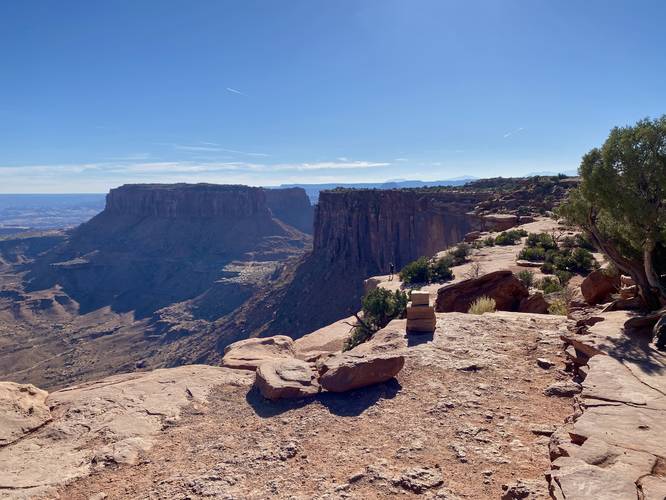
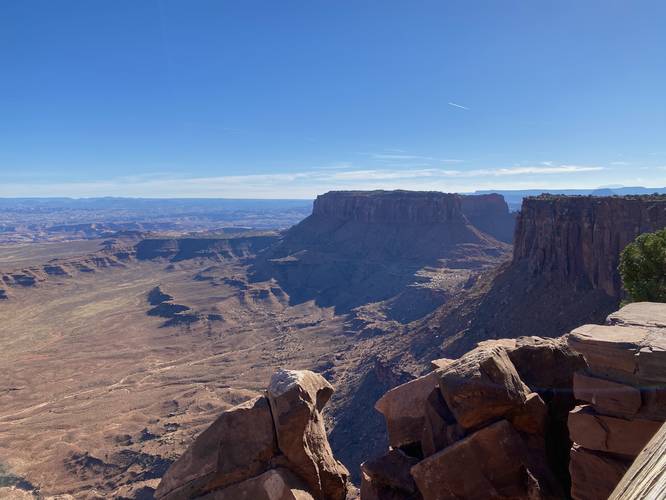
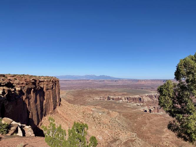
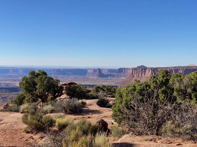
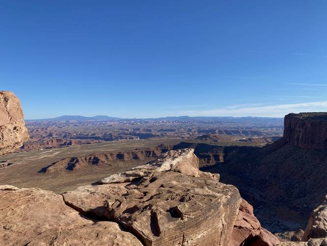
This hike begins at the main trailhead located at the parking lot for Grand View Point Overlook. Hikers will follow the trail, past Grand View Point Overlook, and down the rock steps to follow the Grand View Point Trail. After descending, hikers will follow square-hewn stone rock cairns along the trail to reach a series of stairs that lead back up the bedrock. Along the way, hikers will be following sheer-drop cliff edges which provide panoramic views of the southeastern part of Canyonlands Island in the Sky District. Just below your feet are a plethora of deep-cut canyons that span vast distances in the landscape below. To the southeast, lie large mesa rock outcroppings that provide more neat views for hikers as they make their way south.
Views - Mile 0.1 to 1
Hikers will find that pretty much everywhere they go along this trail, there will be some views -- with the exception of maybe 0.85 to 1; however, there are generally easterly and westerly-facing views throughout the entire hike. The hike back obviously includes views in the same places.
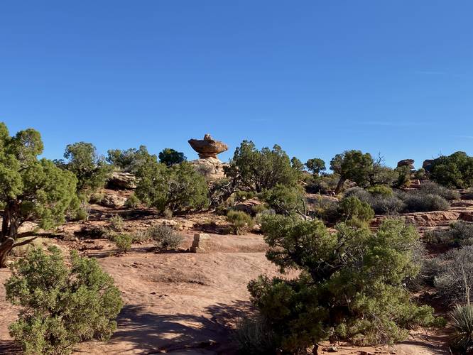
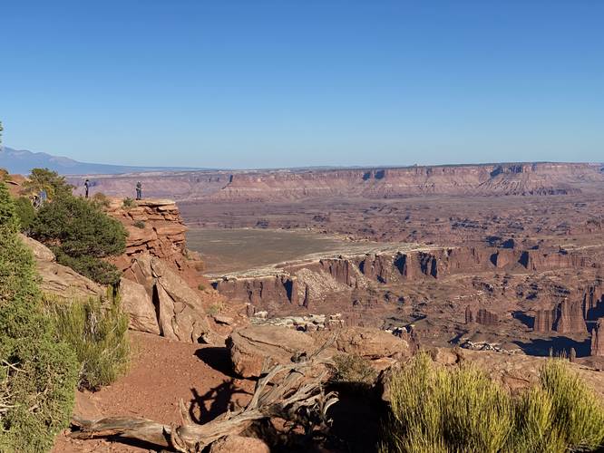
Sombrero Rock - Mile 0.85
Around mile 0.85, hikers may notice a large rock that appears to be balancing on another -- this looks like a Sombrero from afar and at certain angles, hence the name Sombrero Rock.
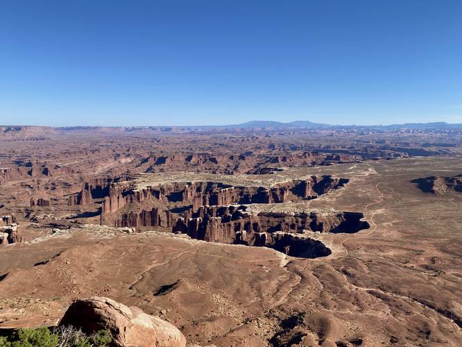
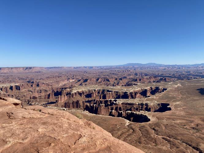
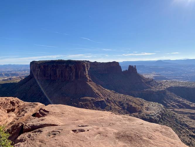
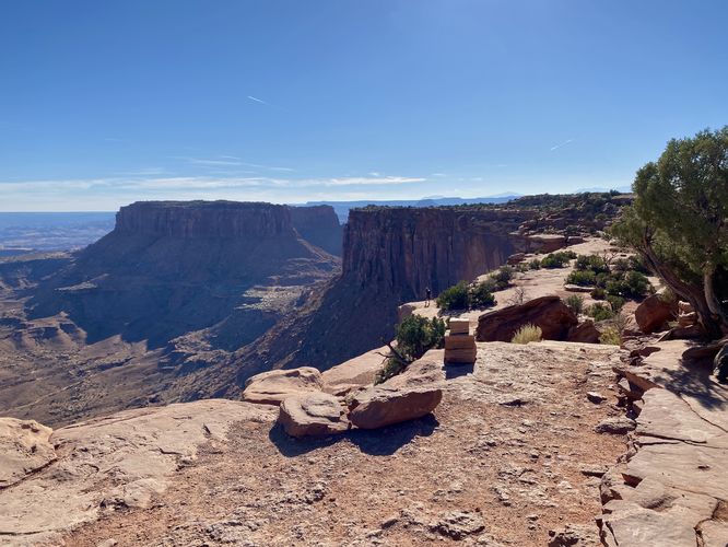
Grand View Point Vistas - Mile 0.95 to 1
At mile 0.95, hikers will reach the end of the trail -- at the cliff's edge where you'll find stunning panoramic views southward into more of Canyonlands National Park. To your southeast, hikers will find the massive rock mesa known as Junction Butte that stands tall between Grand View Point and the Colorado River. Hikers, if they wish, can also scramble up the tall bedrock located to the east of Grand View Point to find another (but similar) view of the area. The view from the top of the rock scramble provides more eastward-facing views toward the Colorado River that can't be seen from the end of the trail.
Hiking Out - Mile 1 to 2
Hikers will obviously follow the same path they took to hike back to parking. Along the way, be sure to stop at and enjoy the plethora of vista points that this trail has to offer. Note that there are several staircases to climb up and out to make it back to parking.
Popularity
This trail is one of the most popular hikes at Canyonlands National Park and for good reason -- hikers get views throughout the entire hike and the views at the end of the trail are stunning.
Parking
Hikers will find parking at the coordinates provided -- located on the side of the road near the very end of Grand View Point Road at Canyonlands National Park.
Pets
Dogs are not allowed on any trails at Canyonlands National Park. Please do not bring your dog here.
Warning
Sun exposure: This trail has very little shade and no water sources. Pack-in all water and wear sun screen and a hat to protect against sun exposure. It's smart to hike either in the early morning or late afternoon to avoid the intense desert sun.
No water: This trail has no water sources so you must pack-in all water. A general rule of thumb in the desert is 1 gallon of water per person per day.
Rattlesnakes: This is rattlesnake territory, so be on the lookout and give any rattlers you find plenty of space.
Steep cliffs: This trail follows steep cliffs. Watch your step and give yourself plenty of space from the edge of the cliffs for your own safety.
Fees
Vehicle entry fees to Canyonlands National Park is $30 as of September 2023.
Hike Description
This hike begins at the main trailhead located at the parking lot for Grand View Point Overlook. Hikers will follow the trail, past Grand View Point Overlook, and down the rock steps to follow the Grand View Point Trail. After descending, hikers will follow square-hewn stone rock cairns along the trail to reach a series of stairs that lead back up the bedrock. Along the way, hikers will be following sheer-drop cliff edges which provide panoramic views of the southeastern part of Canyonlands Island in the Sky District. Just below your feet are a plethora of deep-cut canyons that span vast distances in the landscape below. To the southeast, lie large mesa rock outcroppings that provide more neat views for hikers as they make their way south.
Views - Mile 0.1 to 1
Hikers will find that pretty much everywhere they go along this trail, there will be some views -- with the exception of maybe 0.85 to 1; however, there are generally easterly and westerly-facing views throughout the entire hike. The hike back obviously includes views in the same places.
Sombrero Rock - Mile 0.85
Around mile 0.85, hikers may notice a large rock that appears to be balancing on another -- this looks like a Sombrero from afar and at certain angles, hence the name Sombrero Rock.
Grand View Point Vistas - Mile 0.95 to 1
At mile 0.95, hikers will reach the end of the trail -- at the cliff's edge where you'll find stunning panoramic views southward into more of Canyonlands National Park. To your southeast, hikers will find the massive rock mesa known as Junction Butte that stands tall between Grand View Point and the Colorado River. Hikers, if they wish, can also scramble up the tall bedrock located to the east of Grand View Point to find another (but similar) view of the area. The view from the top of the rock scramble provides more eastward-facing views toward the Colorado River that can't be seen from the end of the trail.
Hiking Out - Mile 1 to 2
Hikers will obviously follow the same path they took to hike back to parking. Along the way, be sure to stop at and enjoy the plethora of vista points that this trail has to offer. Note that there are several staircases to climb up and out to make it back to parking.
Popularity
This trail is one of the most popular hikes at Canyonlands National Park and for good reason -- hikers get views throughout the entire hike and the views at the end of the trail are stunning.
Parking
Hikers will find parking at the coordinates provided -- located on the side of the road near the very end of Grand View Point Road at Canyonlands National Park.
Pets
Dogs are not allowed on any trails at Canyonlands National Park. Please do not bring your dog here.
Warning
Sun exposure: This trail has very little shade and no water sources. Pack-in all water and wear sun screen and a hat to protect against sun exposure. It's smart to hike either in the early morning or late afternoon to avoid the intense desert sun.
No water: This trail has no water sources so you must pack-in all water. A general rule of thumb in the desert is 1 gallon of water per person per day.
Rattlesnakes: This is rattlesnake territory, so be on the lookout and give any rattlers you find plenty of space.
Steep cliffs: This trail follows steep cliffs. Watch your step and give yourself plenty of space from the edge of the cliffs for your own safety.
Fees
Vehicle entry fees to Canyonlands National Park is $30 as of September 2023.